![](/images/other/stat-length.png)
![Trail Walking Beaufort - ARECHES vend Rando pédestre PLANAY / lac du CLOU Boucle - Photo](https://media.geolcdn.com/t/1900/400/ext.pjpeg?maxdim=2&url=https%3A%2F%2Fstatic1.geolcdn.com%2Fsiteimages%2Fupload%2Ffiles%2F1553511878bg_sport_marche.png)
ARECHES vend Rando pédestre PLANAY / lac du CLOU Boucle
Gilbert66
User
![Length](/images/other/stat-length.png)
Length
10.3 km
![Max alt](https://static1.geolcdn.com/siteimages/upload/files/1508320355ic_sort_altitude_max_24dp.png)
Max alt
1674 m
![Uphill gradient](https://static1.geolcdn.com/siteimages/upload/files/1508320355ic_sort_den_pos_24dp.png)
Uphill gradient
549 m
![Km-Effort](/images/other/stat-length.png)
Km-Effort
18.3 km
![Min alt](https://static1.geolcdn.com/siteimages/upload/files/1508320355ic_sort_altitude_min_24dp.png)
Min alt
1007 m
![Downhill gradient](https://static1.geolcdn.com/siteimages/upload/files/1508320355ic_sort_den_neg_24dp.png)
Downhill gradient
738 m
![Boucle](https://static1.geolcdn.com/siteimages/upload/files/16400158638029165_repeat_loop_refresh_sync_direction_icon.png)
Boucle
No
Creation date :
2024-03-22 08:27:39.423
Updated on :
2024-03-27 15:21:01.002
![Walking](https://static1.geolcdn.com/sitytour/trail-icons/101.png)
6h12
Difficulty : Difficult
![Scan this QR Code to open this trail in the SityTrail application](https://capi.geolives.com/qq0zvz2zws4bq2lad0pu/sitytour/trails/3989902/qr.png?size=200)
FREE GPS app for hiking
About
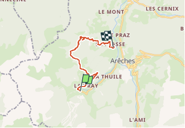
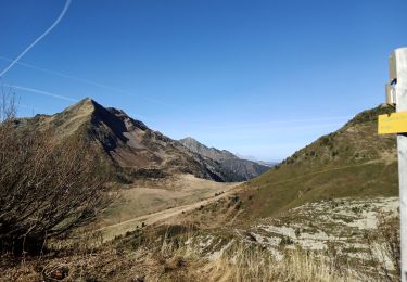
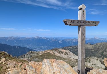
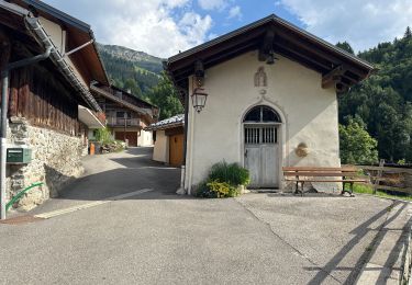
Trail Walking of 10.3 km to be discovered at Auvergne-Rhône-Alpes, Savoy, Beaufort. This trail is proposed by Gilbert66.
Description
R pédestre
Bus Navette Les Carroz / Le Planay .puis rando pédestre en balcon au dessus d'Arèches par le lac Le CLOU et arrivée direct à AZUREVA
Positioning
Country:
France
Region :
Auvergne-Rhône-Alpes
Department/Province :
Savoy
Municipality :
Beaufort
Location:
Unknown
Start:(Dec)
Start:(UTM)
308420 ; 5060596 (32T) N.
Comments
Trails nearby
![Trail Walking Beaufort - D'Arêches au Col de Pré par le hameau de Boudin - Photo](https://media.geolcdn.com/t/375/260/ext.jpg?maxdim=2&url=https%3A%2F%2Fservices.sitytrail.com%2FGeolivesWS%2FDownloadMedia.ashx%3FTrailID%3D112688%26Media%3D11533_5.jpg)
![Walking Walking](https://static1.geolcdn.com/sitytour/trail-icons/101.png)
D'Arêches au Col de Pré par le hameau de Boudin
Walking
Medium
(1)
Beaufort,
Auvergne-Rhône-Alpes,
Savoy,
France
![](/images/other/stat-length.png)
8.2 km | 17.9 km-effort
4h 0min
![](https://static1.geolcdn.com/siteimages/upload/files/16400158638029165_repeat_loop_refresh_sync_direction_icon.png)
Yes
![Trail Walking Cevins - anciennes ardoisières de Cevins et La Bathie - Photo](https://media.geolcdn.com/t/375/260/8382db70-f2f5-4431-a44f-308d438a2649.jpg&format=jpg&maxdim=2)
![Walking Walking](https://static1.geolcdn.com/sitytour/trail-icons/101.png)
anciennes ardoisières de Cevins et La Bathie
Walking
Medium
Cevins,
Auvergne-Rhône-Alpes,
Savoy,
France
![](/images/other/stat-length.png)
14.1 km | 31 km-effort
4h 45min
![](https://static1.geolcdn.com/siteimages/upload/files/16400158638029165_repeat_loop_refresh_sync_direction_icon.png)
Yes
![Trail Walking Beaufort - suuntoapp-Hiking-2024-09-07T06-03-31Z - Photo](https://media.geolcdn.com/t/375/260/1c7a5e77-787c-4d14-8dd4-f96128769e9c.jpg&format=jpg&maxdim=2)
![Walking Walking](https://static1.geolcdn.com/sitytour/trail-icons/101.png)
suuntoapp-Hiking-2024-09-07T06-03-31Z
Walking
Very difficult
Beaufort,
Auvergne-Rhône-Alpes,
Savoy,
France
![](/images/other/stat-length.png)
21 km | 38 km-effort
8h 42min
![](https://static1.geolcdn.com/siteimages/upload/files/16400158638029165_repeat_loop_refresh_sync_direction_icon.png)
No
![Trail Touring skiing Beaufort - Anticime de la pointe de la grande journée, montée couloir du grepets - Photo](https://media.geolcdn.com/t/375/260/8dfd1937-3bd4-42bd-a4fa-284d4bb8802e.jpg&format=jpg&maxdim=2)
![Touring skiing Touring skiing](https://static1.geolcdn.com/sitytour/trail-icons/503.png)
Anticime de la pointe de la grande journée, montée couloir du grepets
Touring skiing
Difficult
Beaufort,
Auvergne-Rhône-Alpes,
Savoy,
France
![](/images/other/stat-length.png)
13.4 km | 30 km-effort
4h 48min
![](https://static1.geolcdn.com/siteimages/upload/files/16400158638029165_repeat_loop_refresh_sync_direction_icon.png)
Yes
![Trail Touring skiing Beaufort - Côte 2000 et col de Roche plane - Photo](https://media.geolcdn.com/t/375/260/38a11e49-5450-4382-89d2-44ae6ea43162.jpg&format=jpg&maxdim=2)
![Touring skiing Touring skiing](https://static1.geolcdn.com/sitytour/trail-icons/503.png)
Côte 2000 et col de Roche plane
Touring skiing
Easy
Beaufort,
Auvergne-Rhône-Alpes,
Savoy,
France
![](/images/other/stat-length.png)
12.5 km | 29 km-effort
6h 46min
![](https://static1.geolcdn.com/siteimages/upload/files/16400158638029165_repeat_loop_refresh_sync_direction_icon.png)
Yes
![Trail Walking Beaufort - Barrage St Guerin Refuge de l’Econdu 12 km - 600 m d’en + - Photo](https://media.geolcdn.com/t/375/260/e237980d-0989-4662-bd24-20be909d7e5b.jpg&format=jpg&maxdim=2)
![Walking Walking](https://static1.geolcdn.com/sitytour/trail-icons/101.png)
Barrage St Guerin Refuge de l’Econdu 12 km - 600 m d’en +
Walking
Medium
Beaufort,
Auvergne-Rhône-Alpes,
Savoy,
France
![](/images/other/stat-length.png)
11.9 km | 20 km-effort
5h 39min
![](https://static1.geolcdn.com/siteimages/upload/files/16400158638029165_repeat_loop_refresh_sync_direction_icon.png)
Yes
![Trail Walking Beaufort - Le pas de l’âne 10 km 850 m dénivelé + - Photo](https://media.geolcdn.com/t/375/260/e16223c0-d24b-4318-beff-cfc74b9fa02c.jpg&format=jpg&maxdim=2)
![Walking Walking](https://static1.geolcdn.com/sitytour/trail-icons/101.png)
Le pas de l’âne 10 km 850 m dénivelé +
Walking
Medium
Beaufort,
Auvergne-Rhône-Alpes,
Savoy,
France
![](/images/other/stat-length.png)
10.2 km | 21 km-effort
7h 59min
![](https://static1.geolcdn.com/siteimages/upload/files/16400158638029165_repeat_loop_refresh_sync_direction_icon.png)
Yes
![Trail Walking Beaufort - Roche Pastrire 8,7 km - Photo](https://media.geolcdn.com/t/375/260/783675ed-dc1c-4b41-82f9-ac57164bc294.jpg&format=jpg&maxdim=2)
![Walking Walking](https://static1.geolcdn.com/sitytour/trail-icons/101.png)
Roche Pastrire 8,7 km
Walking
Medium
Beaufort,
Auvergne-Rhône-Alpes,
Savoy,
France
![](/images/other/stat-length.png)
8.7 km | 15.3 km-effort
4h 23min
![](https://static1.geolcdn.com/siteimages/upload/files/16400158638029165_repeat_loop_refresh_sync_direction_icon.png)
Yes
![Trail Walking Beaufort - Areches col du Pré version 11 km - Photo](https://media.geolcdn.com/t/375/260/7abc590a-8c82-46ce-b467-d226a059a885.jpg&format=jpg&maxdim=2)
![Walking Walking](https://static1.geolcdn.com/sitytour/trail-icons/101.png)
Areches col du Pré version 11 km
Walking
Medium
(1)
Beaufort,
Auvergne-Rhône-Alpes,
Savoy,
France
![](/images/other/stat-length.png)
11.2 km | 21 km-effort
7h 56min
![](https://static1.geolcdn.com/siteimages/upload/files/16400158638029165_repeat_loop_refresh_sync_direction_icon.png)
Yes