![](/images/other/stat-length.png)
![Trail Walking Champigneulles - Champigneulles (Ail des Ours) 13 260m +223m - Photo](https://media.geolcdn.com/t/1900/400/ext.pjpeg?maxdim=2&url=https%3A%2F%2Fstatic1.geolcdn.com%2Fsiteimages%2Fupload%2Ffiles%2F1553511878bg_sport_marche.png)
Champigneulles (Ail des Ours) 13 260m +223m
DanielROLLET
User
![Length](/images/other/stat-length.png)
![Max alt](https://static1.geolcdn.com/siteimages/upload/files/1508320355ic_sort_altitude_max_24dp.png)
![Uphill gradient](https://static1.geolcdn.com/siteimages/upload/files/1508320355ic_sort_den_pos_24dp.png)
![Km-Effort](/images/other/stat-length.png)
![Min alt](https://static1.geolcdn.com/siteimages/upload/files/1508320355ic_sort_altitude_min_24dp.png)
![Downhill gradient](https://static1.geolcdn.com/siteimages/upload/files/1508320355ic_sort_den_neg_24dp.png)
![Boucle](https://static1.geolcdn.com/siteimages/upload/files/16400158638029165_repeat_loop_refresh_sync_direction_icon.png)
![Walking](https://static1.geolcdn.com/sitytour/trail-icons/101.png)
3h41
Difficulty : Difficult
![Scan this QR Code to open this trail in the SityTrail application](https://capi.geolives.com/qq0zvz2zws4bq2lad0pu/sitytour/trails/3986179/qr.png?size=200)
FREE GPS app for hiking
About
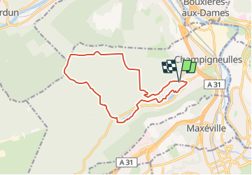
Trail Walking of 13.3 km to be discovered at Grand Est, Meurthe-et-Moselle, Champigneulles. This trail is proposed by DanielROLLET.
Description
2024 03 19 - Avec Marie - 9h05 à 13h05
Pertes temps : rencontré équipe Flore54 cueillette ail des ours lecture de carte par Marie. (environ 40mn)
Sortie AIL DES OURS dans le Vallon de Noirval
Beau temps calme (brouillard au départ)
Départ/retour parking devant piscine
A l'arrivée, rester en rive-gauche du ruisseau des étangs de Champigneulles
Après le départ on peut prendre le sentier (limite de forêt domaniale) au dessus de la route forestière
Positioning
Comments
Trails nearby
![Trail On foot Champigneulles - Circuit G - Photo](https://media.geolcdn.com/t/375/260/367653e8-319c-4965-be92-65937a99215e.jpeg&format=jpg&maxdim=2)
![On foot On foot](https://static1.geolcdn.com/sitytour/trail-icons/100.png)
On foot
![](/images/other/stat-length.png)
![](https://static1.geolcdn.com/siteimages/upload/files/16400158638029165_repeat_loop_refresh_sync_direction_icon.png)
![Trail On foot Champigneulles - Circuit du Val Saint-Barthélémy - Photo](https://media.geolcdn.com/t/375/260/199ee8e6-f9b7-4be8-9188-093275697409.jpeg&format=jpg&maxdim=2)
![On foot On foot](https://static1.geolcdn.com/sitytour/trail-icons/100.png)
On foot
![](/images/other/stat-length.png)
![](https://static1.geolcdn.com/siteimages/upload/files/16400158638029165_repeat_loop_refresh_sync_direction_icon.png)
![Trail On foot Champigneulles - Circuit du Noirval - Photo](https://media.geolcdn.com/t/375/260/199ee8e6-f9b7-4be8-9188-093275697409.jpeg&format=jpg&maxdim=2)
![On foot On foot](https://static1.geolcdn.com/sitytour/trail-icons/100.png)
On foot
![](/images/other/stat-length.png)
![](https://static1.geolcdn.com/siteimages/upload/files/16400158638029165_repeat_loop_refresh_sync_direction_icon.png)
![Trail Walking Nancy - Ma dernière avant opération - Photo](https://media.geolcdn.com/t/375/260/ext.jpg?maxdim=2&url=https%3A%2F%2Fstatic1.geolcdn.com%2Fsiteimages%2Fupload%2Ffiles%2F1553511878bg_sport_marche.png)
![Walking Walking](https://static1.geolcdn.com/sitytour/trail-icons/101.png)
Walking
![](/images/other/stat-length.png)
![](https://static1.geolcdn.com/siteimages/upload/files/16400158638029165_repeat_loop_refresh_sync_direction_icon.png)
![Trail Bicycle tourism Frouard - 4ème rando vélo Frouard - Lagarde 62 km - Photo](https://media.geolcdn.com/t/375/260/13993c5f-3965-404c-880f-e186b1a79db8.jpg&format=jpg&maxdim=2)
![Bicycle tourism Bicycle tourism](https://static1.geolcdn.com/sitytour/trail-icons/204.png)
Bicycle tourism
![](/images/other/stat-length.png)
![](https://static1.geolcdn.com/siteimages/upload/files/16400158638029165_repeat_loop_refresh_sync_direction_icon.png)
![Trail Walking Nancy - Ma rando du jour - Photo](https://media.geolcdn.com/t/375/260/c990ad83-2661-43f9-99e0-4498fd5d020a.jpg&format=jpg&maxdim=2)
![Walking Walking](https://static1.geolcdn.com/sitytour/trail-icons/101.png)
Walking
![](/images/other/stat-length.png)
![](https://static1.geolcdn.com/siteimages/upload/files/16400158638029165_repeat_loop_refresh_sync_direction_icon.png)
![Trail Walking Nancy - Nancy Gondreville Nancy - Photo](https://media.geolcdn.com/t/375/260/171b4f53-1717-4b2e-9789-6c40dd8e1481.jpg&format=jpg&maxdim=2)
![Walking Walking](https://static1.geolcdn.com/sitytour/trail-icons/101.png)
Walking
![](/images/other/stat-length.png)
![](https://static1.geolcdn.com/siteimages/upload/files/16400158638029165_repeat_loop_refresh_sync_direction_icon.png)
![Trail Walking Nancy - Nancy Saizeray Jaillon Pierre la Treiche Marion Nancy - Photo](https://media.geolcdn.com/t/375/260/9e40712a-6db3-4fe8-9edd-58851d16cb4f.jpg&format=jpg&maxdim=2)
![Walking Walking](https://static1.geolcdn.com/sitytour/trail-icons/101.png)
Walking
![](/images/other/stat-length.png)
![](https://static1.geolcdn.com/siteimages/upload/files/16400158638029165_repeat_loop_refresh_sync_direction_icon.png)
![Trail On foot Lay-Saint-Christophe - Circuit L - Photo](https://media.geolcdn.com/t/375/260/8edc069d-a9b9-439a-9f46-3e2f5923a387.jpeg&format=jpg&maxdim=2)
![On foot On foot](https://static1.geolcdn.com/sitytour/trail-icons/100.png)
On foot
![](/images/other/stat-length.png)
![](https://static1.geolcdn.com/siteimages/upload/files/16400158638029165_repeat_loop_refresh_sync_direction_icon.png)