![](/images/other/stat-length.png)
![Trail Walking Ferreries - Cala Galdana – Son Xoriguer - Photo](https://media.geolcdn.com/t/1900/400/8aaec74c-0505-4e44-a93f-fb68c719db42.jpg&format=pjpeg&maxdim=2)
Cala Galdana – Son Xoriguer
Geert H.
User
![Length](/images/other/stat-length.png)
Length
17.1 km
![Max alt](https://static1.geolcdn.com/siteimages/upload/files/1508320355ic_sort_altitude_max_24dp.png)
Max alt
56 m
![Uphill gradient](https://static1.geolcdn.com/siteimages/upload/files/1508320355ic_sort_den_pos_24dp.png)
Uphill gradient
204 m
![Km-Effort](/images/other/stat-length.png)
Km-Effort
20 km
![Min alt](https://static1.geolcdn.com/siteimages/upload/files/1508320355ic_sort_altitude_min_24dp.png)
Min alt
0 m
![Downhill gradient](https://static1.geolcdn.com/siteimages/upload/files/1508320355ic_sort_den_neg_24dp.png)
Downhill gradient
252 m
![Boucle](https://static1.geolcdn.com/siteimages/upload/files/16400158638029165_repeat_loop_refresh_sync_direction_icon.png)
Boucle
No
Creation date :
2024-03-18 08:57:22.464
Updated on :
2024-05-17 11:15:05.716
![Walking](https://static1.geolcdn.com/sitytour/trail-icons/101.png)
4h00
Difficulty : Very difficult
![Scan this QR Code to open this trail in the SityTrail application](https://capi.geolives.com/qq0zvz2zws4bq2lad0pu/sitytour/trails/3985203/qr.png?size=200)
FREE GPS app for hiking
About
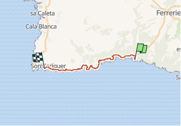
Trail Walking of 17.1 km to be discovered at Balearic Islands, Unknown, Ferreries. This trail is proposed by Geert H..
Description
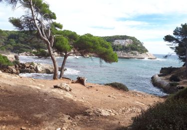
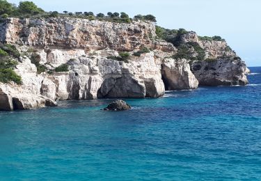
Vanuit Cala Galdana kom je verschillende kleine, mooi gelegen baaien voorbij.
De strandjes van Turqueta, Son Saura en Macaralleta zorgen voor ideale rustpunten. Afwisselend langs eikenbomen, dennenbomen, olijfbomen en akkers.
Positioning
Country:
Spain
Region :
Balearic Islands
Department/Province :
Unknown
Municipality :
Ferreries
Location:
Unknown
Start:(Dec)
Start:(UTM)
582223 ; 4420891 (31S) N.
Comments
Trails nearby
![Trail Walking Ferreries - 20231026minorque - Photo](https://media.geolcdn.com/t/375/260/25806b4b-0403-42d3-ba3b-f0f15df7f33f.jpg&format=jpg&maxdim=2)
![Walking Walking](https://static1.geolcdn.com/sitytour/trail-icons/101.png)
20231026minorque
Walking
Difficult
Ferreries,
Balearic Islands,
Unknown,
Spain
![](/images/other/stat-length.png)
10.7 km | 13.8 km-effort
4h 26min
![](https://static1.geolcdn.com/siteimages/upload/files/16400158638029165_repeat_loop_refresh_sync_direction_icon.png)
No
![Trail Walking Ciutadella - 20231022minorque - Photo](https://media.geolcdn.com/t/375/260/fb802431-005a-4c4d-a579-9eca6837e6f2.jpg&format=jpg&maxdim=2)
![Walking Walking](https://static1.geolcdn.com/sitytour/trail-icons/101.png)
20231022minorque
Walking
Difficult
Ciutadella,
Balearic Islands,
Unknown,
Spain
![](/images/other/stat-length.png)
11.5 km | 14.9 km-effort
5h 42min
![](https://static1.geolcdn.com/siteimages/upload/files/16400158638029165_repeat_loop_refresh_sync_direction_icon.png)
No
![Trail Walking Ciutadella - playa maquinela - Photo](https://media.geolcdn.com/t/375/260/ext.jpg?maxdim=2&url=https%3A%2F%2Fstatic1.geolcdn.com%2Fsiteimages%2Fupload%2Ffiles%2F1553511878bg_sport_marche.png)
![Walking Walking](https://static1.geolcdn.com/sitytour/trail-icons/101.png)
playa maquinela
Walking
Easy
Ciutadella,
Balearic Islands,
Unknown,
Spain
![](/images/other/stat-length.png)
3.1 km | 4.1 km-effort
56min
![](https://static1.geolcdn.com/siteimages/upload/files/16400158638029165_repeat_loop_refresh_sync_direction_icon.png)
Yes
![Trail Walking es Migjorn Gran - Cala Escorxada - Photo](https://media.geolcdn.com/t/375/260/ext.jpg?maxdim=2&url=https%3A%2F%2Fstatic1.geolcdn.com%2Fsiteimages%2Fupload%2Ffiles%2F1553511878bg_sport_marche.png)
![Walking Walking](https://static1.geolcdn.com/sitytour/trail-icons/101.png)
Cala Escorxada
Walking
Easy
es Migjorn Gran,
Balearic Islands,
Unknown,
Spain
![](/images/other/stat-length.png)
3.6 km | 4.4 km-effort
55min
![](https://static1.geolcdn.com/siteimages/upload/files/16400158638029165_repeat_loop_refresh_sync_direction_icon.png)
No
![Trail Walking Ciutadella - De Cala Galdana à San Bou - Photo](https://media.geolcdn.com/t/375/260/ext.jpg?maxdim=2&url=https%3A%2F%2Fstatic1.geolcdn.com%2Fsiteimages%2Fupload%2Ffiles%2F1553511878bg_sport_marche.png)
![Walking Walking](https://static1.geolcdn.com/sitytour/trail-icons/101.png)
De Cala Galdana à San Bou
Walking
Easy
Ciutadella,
Balearic Islands,
Unknown,
Spain
![](/images/other/stat-length.png)
11.1 km | 14.5 km-effort
2h 40min
![](https://static1.geolcdn.com/siteimages/upload/files/16400158638029165_repeat_loop_refresh_sync_direction_icon.png)
No
![Trail Walking Ferreries - minorca J5 - Photo](https://media.geolcdn.com/t/375/260/ext.jpg?maxdim=2&url=https%3A%2F%2Fstatic1.geolcdn.com%2Fsiteimages%2Fupload%2Ffiles%2F1553511878bg_sport_marche.png)
![Walking Walking](https://static1.geolcdn.com/sitytour/trail-icons/101.png)
minorca J5
Walking
Difficult
Ferreries,
Balearic Islands,
Unknown,
Spain
![](/images/other/stat-length.png)
14.4 km | 18.2 km-effort
4h 38min
![](https://static1.geolcdn.com/siteimages/upload/files/16400158638029165_repeat_loop_refresh_sync_direction_icon.png)
No
![Trail Walking Ferreries - Galdana - Mijana - Trebaluger - Photo](https://media.geolcdn.com/t/375/260/ext.jpg?maxdim=2&url=https%3A%2F%2Fstatic1.geolcdn.com%2Fsiteimages%2Fupload%2Ffiles%2F1553511878bg_sport_marche.png)
![Walking Walking](https://static1.geolcdn.com/sitytour/trail-icons/101.png)
Galdana - Mijana - Trebaluger
Walking
Medium
Ferreries,
Balearic Islands,
Unknown,
Spain
![](/images/other/stat-length.png)
5.8 km | 7.8 km-effort
1h 46min
![](https://static1.geolcdn.com/siteimages/upload/files/16400158638029165_repeat_loop_refresh_sync_direction_icon.png)
Yes
![Trail Walking Ciutadella - Macarella-Macaralleta-Turqueta - Photo](https://media.geolcdn.com/t/375/260/ext.jpg?maxdim=2&url=https%3A%2F%2Fstatic1.geolcdn.com%2Fsiteimages%2Fupload%2Ffiles%2F1553511878bg_sport_marche.png)
![Walking Walking](https://static1.geolcdn.com/sitytour/trail-icons/101.png)
Macarella-Macaralleta-Turqueta
Walking
Medium
Ciutadella,
Balearic Islands,
Unknown,
Spain
![](/images/other/stat-length.png)
6.5 km | 8.2 km-effort
1h 52min
![](https://static1.geolcdn.com/siteimages/upload/files/16400158638029165_repeat_loop_refresh_sync_direction_icon.png)
Yes
![Trail Walking Ciutadella - minorque galanada en famille - Photo](https://media.geolcdn.com/t/375/260/ext.jpg?maxdim=2&url=https%3A%2F%2Fstatic1.geolcdn.com%2Fsiteimages%2Fupload%2Ffiles%2F1553511878bg_sport_marche.png)
![Walking Walking](https://static1.geolcdn.com/sitytour/trail-icons/101.png)
minorque galanada en famille
Walking
Difficult
Ciutadella,
Balearic Islands,
Unknown,
Spain
![](/images/other/stat-length.png)
10.6 km | 13.7 km-effort
3h 34min
![](https://static1.geolcdn.com/siteimages/upload/files/16400158638029165_repeat_loop_refresh_sync_direction_icon.png)
No