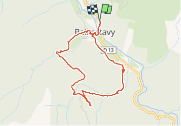
Trail Walking Baillestavy - Baillestavy, el correc de Font Fresca - Photo

Baillestavy, el correc de Font Fresca

© OpenStreetMap contributors
Length
Length
5 km
Max alt
Max alt
855 m
Uphill gradient
Uphill gradient
282 m
Km-Effort
Km-Effort  
8.8 km
Min alt
Min alt
583 m
Downhill gradient
Downhill gradient
284 m
Boucle
Boucle
Yes
Creation date :
2024-03-17 09:14:43.782
Updated on :
2024-03-17 17:11:10.343

(0 Reviews)

Walking
Walking
3h11
Difficulty : Easy

Scan this QR Code to open this trail in the SityTrail application

FREE GPS app for hiking

Logo SityTrail SityTrail

IGN / Geographical institutes

Download SityTrail from the App Store Download SityTrail from Google Play

Logo SityTrail SityTrail World

The world is yours!

Download SityTrail from the App Store Download SityTrail from Google Play Download SityTrail on Huawei AppGallery

About

Trail Walking of 5 km to be discovered at Occitania, Pyrénées-Orientales, Baillestavy. This trail is proposed by Santblasi.

Description

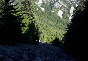
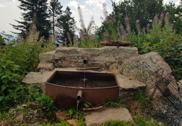
Parking La  Força, grimper jusqu'à la place ; suivre la piste de Coma puis un sentier en suivant le GR36.
Suivre direction Valmanya à la variante, traverser le correc de Front Fresca.
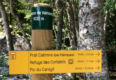
plus haut, quitter le GR et suivre le balisage jaune à plat. Contourner le vieux cortal et descendre jusqu'à la route.
terminer en suivant un sentier de terre qui ramène au village et retrouver le parking.

Elevation profile

Positioning

Country:
France
Region :
Occitania
Department/Province :
Pyrénées-Orientales
Municipality :
Baillestavy
Location:
Unknown
Start:(UTM)
461125 ; 4712738 (31T) N.

Trails nearby

Trail Walking Baillestavy - 20221127 Baillestavy- Valmanya - - Prat Mitja - Photo
Walking
ThonyM

Walking

Difficult
Baillestavy, Occitania, Pyrénées-Orientales, France
16.8 km | 30 km-effort
5h 2min
Yes
Trail Walking Baillestavy - 20220519 Ballestavy - Photo
Walking
ThonyM

Walking

Medium
Baillestavy, Occitania, Pyrénées-Orientales, France
12.6 km | 21 km-effort
3h 28min
Yes
Trail Walking Estoher - 20220227 Mas Maler- Mines de la Coume - Photo
Walking
ThonyM

Walking

Difficult
Estoher, Occitania, Pyrénées-Orientales, France
15.2 km | 30 km-effort
5h 35min
Yes
Trail Walking Valmanya - Los Masos Prat Cabrera - Photo
Walking
oscar1

Walking

Very difficult
Valmanya, Occitania, Pyrénées-Orientales, France
12.6 km | 23 km-effort
3h 37min
Yes
Trail Walking Valmanya - 20210705 Pic du Canigou par L’os Masos de Valmanya - Photo
Walking
ThonyM

Walking

Difficult
Valmanya, Occitania, Pyrénées-Orientales, France
23 km | 49 km-effort
7h 12min
Yes
Trail Walking Estoher - 20201025 tour du Jocavell depuis Mas Malet  - Photo
Walking
ThonyM

Walking

Medium
Estoher, Occitania, Pyrénées-Orientales, France
15.2 km | 30 km-effort
5h 55min
Yes
Trail Walking Valmanya - 20200815 Los Masos - Pinatell - Photo
Walking
ThonyM

Walking

Medium
Valmanya, Occitania, Pyrénées-Orientales, France
12.6 km | 23 km-effort
3h 47min
Yes
Trail Walking Valmanya - Balcon du Canigou - Photo
Walking
MarieFrancoise

Walking

Medium
Valmanya, Occitania, Pyrénées-Orientales, France
19.1 km | 32 km-effort
7h 17min
No
Trail Walking Estoher - Estoher - St Jeantres belle promenade pas  - Photo
Walking
ThonyM

Walking

Medium
Estoher, Occitania, Pyrénées-Orientales, France
8 km | 15.7 km-effort
5h 0min
Yes


Close
My subscriptions