![](/images/other/stat-length.png)
![Trail Bouxières-aux-Dames - Parc des etangs - Photo](https://media.geolcdn.com/t/1900/400/ext.pjpeg?maxdim=2&url=https%3A%2F%2Fsecurestorage.geolives.com%2Fsitytour%2Ftrail-bg%2Fdefault.jpg)
Parc des etangs
lorenzot54
User
![Length](/images/other/stat-length.png)
Length
34 km
![Max alt](https://static1.geolcdn.com/siteimages/upload/files/1508320355ic_sort_altitude_max_24dp.png)
Max alt
247 m
![Uphill gradient](https://static1.geolcdn.com/siteimages/upload/files/1508320355ic_sort_den_pos_24dp.png)
Uphill gradient
327 m
![Km-Effort](/images/other/stat-length.png)
Km-Effort
38 km
![Min alt](https://static1.geolcdn.com/siteimages/upload/files/1508320355ic_sort_altitude_min_24dp.png)
Min alt
183 m
![Downhill gradient](https://static1.geolcdn.com/siteimages/upload/files/1508320355ic_sort_den_neg_24dp.png)
Downhill gradient
326 m
![Boucle](https://static1.geolcdn.com/siteimages/upload/files/16400158638029165_repeat_loop_refresh_sync_direction_icon.png)
Boucle
Yes
Creation date :
2024-03-17 07:37:59.0
Updated on :
2024-03-17 09:49:55.894
![Scan this QR Code to open this trail in the SityTrail application](https://capi.geolives.com/qq0zvz2zws4bq2lad0pu/sitytour/trails/3983541/qr.png?size=200)
FREE GPS app for hiking
About
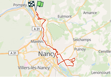
Trail of 34 km to be discovered at Grand Est, Meurthe-et-Moselle, Bouxières-aux-Dames. This trail is proposed by lorenzot54.
Description
Bord de Meurthe rive droite, passerelle des moulins, passerelle pole aviron, pont de Tomblaine, direction Saulxures
Retour bord de Meurthe
Parcours en voie verte
Positioning
Country:
France
Region :
Grand Est
Department/Province :
Meurthe-et-Moselle
Municipality :
Bouxières-aux-Dames
Location:
Unknown
Start:(Dec)
Start:(UTM)
291172 ; 5404341 (32U) N.
Comments
Trails nearby
![Trail On foot Champigneulles - Circuit G - Photo](https://media.geolcdn.com/t/375/260/367653e8-319c-4965-be92-65937a99215e.jpeg&format=jpg&maxdim=2)
![On foot On foot](https://static1.geolcdn.com/sitytour/trail-icons/100.png)
Circuit G
On foot
Medium
Champigneulles,
Grand Est,
Meurthe-et-Moselle,
France
![](/images/other/stat-length.png)
18.7 km | 24 km-effort
5h 24min
![](https://static1.geolcdn.com/siteimages/upload/files/16400158638029165_repeat_loop_refresh_sync_direction_icon.png)
No
![Trail On foot Champigneulles - Circuit du Val Saint-Barthélémy - Photo](https://media.geolcdn.com/t/375/260/199ee8e6-f9b7-4be8-9188-093275697409.jpeg&format=jpg&maxdim=2)
![On foot On foot](https://static1.geolcdn.com/sitytour/trail-icons/100.png)
Circuit du Val Saint-Barthélémy
On foot
Easy
Champigneulles,
Grand Est,
Meurthe-et-Moselle,
France
![](/images/other/stat-length.png)
7 km | 8.6 km-effort
1h 57min
![](https://static1.geolcdn.com/siteimages/upload/files/16400158638029165_repeat_loop_refresh_sync_direction_icon.png)
Yes
![Trail On foot Champigneulles - Circuit du Noirval - Photo](https://media.geolcdn.com/t/375/260/199ee8e6-f9b7-4be8-9188-093275697409.jpeg&format=jpg&maxdim=2)
![On foot On foot](https://static1.geolcdn.com/sitytour/trail-icons/100.png)
Circuit du Noirval
On foot
Easy
Champigneulles,
Grand Est,
Meurthe-et-Moselle,
France
![](/images/other/stat-length.png)
11.1 km | 13.5 km-effort
3h 4min
![](https://static1.geolcdn.com/siteimages/upload/files/16400158638029165_repeat_loop_refresh_sync_direction_icon.png)
Yes
![Trail Bicycle tourism Frouard - 4ème rando vélo Frouard - Lagarde 62 km - Photo](https://media.geolcdn.com/t/375/260/13993c5f-3965-404c-880f-e186b1a79db8.jpg&format=jpg&maxdim=2)
![Bicycle tourism Bicycle tourism](https://static1.geolcdn.com/sitytour/trail-icons/204.png)
4ème rando vélo Frouard - Lagarde 62 km
Bicycle tourism
Very difficult
Frouard,
Grand Est,
Meurthe-et-Moselle,
France
![](/images/other/stat-length.png)
62 km | 67 km-effort
4h 32min
![](https://static1.geolcdn.com/siteimages/upload/files/16400158638029165_repeat_loop_refresh_sync_direction_icon.png)
No
![Trail On foot Lay-Saint-Christophe - Circuit L - Photo](https://media.geolcdn.com/t/375/260/8edc069d-a9b9-439a-9f46-3e2f5923a387.jpeg&format=jpg&maxdim=2)
![On foot On foot](https://static1.geolcdn.com/sitytour/trail-icons/100.png)
Circuit L
On foot
Easy
Lay-Saint-Christophe,
Grand Est,
Meurthe-et-Moselle,
France
![](/images/other/stat-length.png)
14.7 km | 18.5 km-effort
4h 11min
![](https://static1.geolcdn.com/siteimages/upload/files/16400158638029165_repeat_loop_refresh_sync_direction_icon.png)
Yes
![Trail On foot Champigneulles - Circuit G : Circuit principal - Photo](https://media.geolcdn.com/t/375/260/367653e8-319c-4965-be92-65937a99215e.jpeg&format=jpg&maxdim=2)
![On foot On foot](https://static1.geolcdn.com/sitytour/trail-icons/100.png)
Circuit G : Circuit principal
On foot
Easy
Champigneulles,
Grand Est,
Meurthe-et-Moselle,
France
![](/images/other/stat-length.png)
8.4 km | 11.1 km-effort
2h 31min
![](https://static1.geolcdn.com/siteimages/upload/files/16400158638029165_repeat_loop_refresh_sync_direction_icon.png)
No
![Trail On foot Champigneulles - Circuit de Bellefontaine - général ouest - Photo](https://media.geolcdn.com/t/375/260/afefad02-ca10-49a0-94f8-a0d611ca2a91.jpeg&format=jpg&maxdim=2)
![On foot On foot](https://static1.geolcdn.com/sitytour/trail-icons/100.png)
Circuit de Bellefontaine - général ouest
On foot
Easy
Champigneulles,
Grand Est,
Meurthe-et-Moselle,
France
![](/images/other/stat-length.png)
6.1 km | 8 km-effort
1h 48min
![](https://static1.geolcdn.com/siteimages/upload/files/16400158638029165_repeat_loop_refresh_sync_direction_icon.png)
No
![Trail On foot Champigneulles - Circuit du Vallum de la Fourasse - Photo](https://media.geolcdn.com/t/375/260/ff5ef522-89ca-4a55-89a5-b4737ce72d51.jpeg&format=jpg&maxdim=2)
![On foot On foot](https://static1.geolcdn.com/sitytour/trail-icons/100.png)
Circuit du Vallum de la Fourasse
On foot
Easy
Champigneulles,
Grand Est,
Meurthe-et-Moselle,
France
![](/images/other/stat-length.png)
3.3 km | 4.9 km-effort
1h 6min
![](https://static1.geolcdn.com/siteimages/upload/files/16400158638029165_repeat_loop_refresh_sync_direction_icon.png)
Yes
![Trail On foot Marbache - Circuit de la Vierge de Belleville - Photo](https://media.geolcdn.com/t/375/260/ed731c2b-3434-456a-907f-b6c3a07468bd.jpeg&format=jpg&maxdim=2)
![On foot On foot](https://static1.geolcdn.com/sitytour/trail-icons/100.png)
Circuit de la Vierge de Belleville
On foot
Easy
Marbache,
Grand Est,
Meurthe-et-Moselle,
France
![](/images/other/stat-length.png)
6 km | 8.5 km-effort
1h 55min
![](https://static1.geolcdn.com/siteimages/upload/files/16400158638029165_repeat_loop_refresh_sync_direction_icon.png)
Yes