![](/images/other/stat-length.png)
![Trail Walking Bassillac et Auberoche - Blis-et-Born Fontbrejade 11km - Photo](https://media.geolcdn.com/t/1900/400/ext.pjpeg?maxdim=2&url=https%3A%2F%2Fstatic1.geolcdn.com%2Fsiteimages%2Fupload%2Ffiles%2F1553511878bg_sport_marche.png)
Blis-et-Born Fontbrejade 11km
YV24
User
![Length](/images/other/stat-length.png)
Length
10.4 km
![Max alt](https://static1.geolcdn.com/siteimages/upload/files/1508320355ic_sort_altitude_max_24dp.png)
Max alt
227 m
![Uphill gradient](https://static1.geolcdn.com/siteimages/upload/files/1508320355ic_sort_den_pos_24dp.png)
Uphill gradient
228 m
![Km-Effort](/images/other/stat-length.png)
Km-Effort
13.5 km
![Min alt](https://static1.geolcdn.com/siteimages/upload/files/1508320355ic_sort_altitude_min_24dp.png)
Min alt
117 m
![Downhill gradient](https://static1.geolcdn.com/siteimages/upload/files/1508320355ic_sort_den_neg_24dp.png)
Downhill gradient
227 m
![Boucle](https://static1.geolcdn.com/siteimages/upload/files/16400158638029165_repeat_loop_refresh_sync_direction_icon.png)
Boucle
Yes
Creation date :
2018-01-29 00:00:00.0
Updated on :
2018-01-29 00:00:00.0
![Walking](https://static1.geolcdn.com/sitytour/trail-icons/101.png)
2h56
Difficulty : Easy
![Scan this QR Code to open this trail in the SityTrail application](https://capi.geolives.com/qq0zvz2zws4bq2lad0pu/sitytour/trails/398352/qr.png?size=200)
FREE GPS app for hiking
About
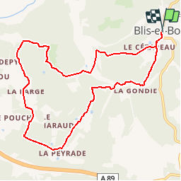
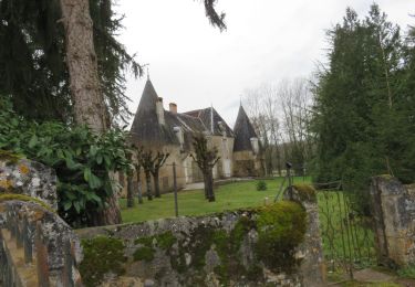
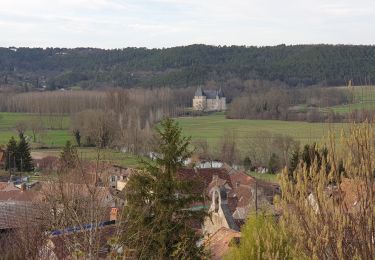
Trail Walking of 10.4 km to be discovered at New Aquitaine, Dordogne, Bassillac et Auberoche. This trail is proposed by YV24.
Description
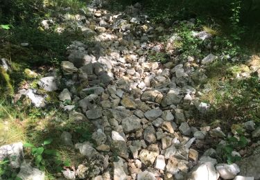
Fontbrejade selon PDIPR n°4 carte St Pierre de Chignac. Bien tracé, balisé, praticable en tout temps. Raidillon en fin de boucle.Le panneautage est optimiste avec ses 12,8km, c'est plutôt 10,6km.
Positioning
Country:
France
Region :
New Aquitaine
Department/Province :
Dordogne
Municipality :
Bassillac et Auberoche
Location:
Unknown
Start:(Dec)
Start:(UTM)
335616 ; 5005289 (31T) N.
Comments
Trails nearby
![Trail Walking Bassillac et Auberoche - Le Change Roc 9km - Photo](https://media.geolcdn.com/t/375/260/ext.jpg?maxdim=2&url=https%3A%2F%2Fstatic1.geolcdn.com%2Fsiteimages%2Fupload%2Ffiles%2F1553511878bg_sport_marche.png)
![Walking Walking](https://static1.geolcdn.com/sitytour/trail-icons/101.png)
Le Change Roc 9km
Walking
Very easy
(1)
Bassillac et Auberoche,
New Aquitaine,
Dordogne,
France
![](/images/other/stat-length.png)
9.3 km | 12.2 km-effort
2h 43min
![](https://static1.geolcdn.com/siteimages/upload/files/16400158638029165_repeat_loop_refresh_sync_direction_icon.png)
Yes
![Trail Walking Bassillac et Auberoche - Le Change Pommiers 9km - Photo](https://media.geolcdn.com/t/375/260/ext.jpg?maxdim=2&url=https%3A%2F%2Fstatic1.geolcdn.com%2Fsiteimages%2Fupload%2Ffiles%2F1553511878bg_sport_marche.png)
![Walking Walking](https://static1.geolcdn.com/sitytour/trail-icons/101.png)
Le Change Pommiers 9km
Walking
Easy
(1)
Bassillac et Auberoche,
New Aquitaine,
Dordogne,
France
![](/images/other/stat-length.png)
9 km | 11.3 km-effort
2h 32min
![](https://static1.geolcdn.com/siteimages/upload/files/16400158638029165_repeat_loop_refresh_sync_direction_icon.png)
Yes
![Trail On foot Bassillac et Auberoche - Les chabannes - Photo](https://media.geolcdn.com/t/375/260/ext.jpg?maxdim=2&url=https%3A%2F%2Fmedia.geolcdn.com%2Ff%2Fa8aade46-e147-4b35-b4a7-c1d555488ef4.jpg)
![On foot On foot](https://static1.geolcdn.com/sitytour/trail-icons/100.png)
Les chabannes
On foot
Easy
Bassillac et Auberoche,
New Aquitaine,
Dordogne,
France
![](/images/other/stat-length.png)
6.3 km | 8.2 km-effort
1h 52min
![](https://static1.geolcdn.com/siteimages/upload/files/16400158638029165_repeat_loop_refresh_sync_direction_icon.png)
Yes
![Trail Walking Cubjac-Auvézère-Val d'Ans - Le chemin du Causse - Cubjac - Photo](https://media.geolcdn.com/t/375/260/ext.jpg?maxdim=2&url=https%3A%2F%2Fservices.sitytrail.com%2FGeolivesWS%2FDownloadMedia.ashx%3FTrailID%3D111446%26Media%3D7295_3.jpg)
![Walking Walking](https://static1.geolcdn.com/sitytour/trail-icons/101.png)
Le chemin du Causse - Cubjac
Walking
Medium
Cubjac-Auvézère-Val d'Ans,
New Aquitaine,
Dordogne,
France
![](/images/other/stat-length.png)
7.9 km | 10 km-effort
2h 0min
![](https://static1.geolcdn.com/siteimages/upload/files/16400158638029165_repeat_loop_refresh_sync_direction_icon.png)
Yes
![Trail Walking Saint-Pierre-de-Chignac - boucle chai lamardie - Photo](https://media.geolcdn.com/t/375/260/ext.jpg?maxdim=2&url=https%3A%2F%2Fmedia.geolcdn.com%2Ff%2F21e6bc13-c5ca-4323-a746-a80ff6aa9b77.jpg)
![Walking Walking](https://static1.geolcdn.com/sitytour/trail-icons/101.png)
boucle chai lamardie
Walking
Easy
Saint-Pierre-de-Chignac,
New Aquitaine,
Dordogne,
France
![](/images/other/stat-length.png)
8.6 km | 11 km-effort
2h 45min
![](https://static1.geolcdn.com/siteimages/upload/files/16400158638029165_repeat_loop_refresh_sync_direction_icon.png)
Yes
![Trail Walking Cubjac-Auvézère-Val d'Ans - track - Photo](https://media.geolcdn.com/t/375/260/ext.jpg?maxdim=2&url=https%3A%2F%2Fmedia.geolcdn.com%2Ff%2F95906e7d-be53-4c4e-b251-9aa7f2a1ea2d.JPG)
![Walking Walking](https://static1.geolcdn.com/sitytour/trail-icons/101.png)
track
Walking
Very difficult
Cubjac-Auvézère-Val d'Ans,
New Aquitaine,
Dordogne,
France
![](/images/other/stat-length.png)
15.4 km | 19.7 km-effort
4h 28min
![](https://static1.geolcdn.com/siteimages/upload/files/16400158638029165_repeat_loop_refresh_sync_direction_icon.png)
Yes
![Trail Walking Montagnac-d'Auberoche - Boucle de la fontaine Marceau ( Montagnac d’ Auberoche) - Photo](https://media.geolcdn.com/t/375/260/ext.jpg?maxdim=2&url=https%3A%2F%2Fmedia.geolcdn.com%2Ff%2Fdcf764e8-3947-4f29-9e0e-bbb82c8d0a4a.jpg)
![Walking Walking](https://static1.geolcdn.com/sitytour/trail-icons/101.png)
Boucle de la fontaine Marceau ( Montagnac d’ Auberoche)
Walking
Easy
Montagnac-d'Auberoche,
New Aquitaine,
Dordogne,
France
![](/images/other/stat-length.png)
6.9 km | 8.6 km-effort
2h 9min
![](https://static1.geolcdn.com/siteimages/upload/files/16400158638029165_repeat_loop_refresh_sync_direction_icon.png)
Yes
![Trail Walking Cubjac-Auvézère-Val d'Ans - Boucle des Quatre Paroisses - Photo](https://media.geolcdn.com/t/375/260/ext.jpg?maxdim=2&url=https%3A%2F%2Fmedia.geolcdn.com%2Ff%2F760938ba-4fea-4056-a763-6c0429a09af1.jpg)
![Walking Walking](https://static1.geolcdn.com/sitytour/trail-icons/101.png)
Boucle des Quatre Paroisses
Walking
Difficult
Cubjac-Auvézère-Val d'Ans,
New Aquitaine,
Dordogne,
France
![](/images/other/stat-length.png)
12.3 km | 15.9 km-effort
3h 36min
![](https://static1.geolcdn.com/siteimages/upload/files/16400158638029165_repeat_loop_refresh_sync_direction_icon.png)
Yes
![Trail Walking Escoire - Boucle Escoire, départ de château. - Photo](https://media.geolcdn.com/t/375/260/ext.jpg?maxdim=2&url=https%3A%2F%2Fmedia.geolcdn.com%2Ff%2F3456106b-95e0-41d2-aaa1-fa25c824c727.jpg)
![Walking Walking](https://static1.geolcdn.com/sitytour/trail-icons/101.png)
Boucle Escoire, départ de château.
Walking
Easy
Escoire,
New Aquitaine,
Dordogne,
France
![](/images/other/stat-length.png)
12 km | 15.7 km-effort
3h 1min
![](https://static1.geolcdn.com/siteimages/upload/files/16400158638029165_repeat_loop_refresh_sync_direction_icon.png)
Yes