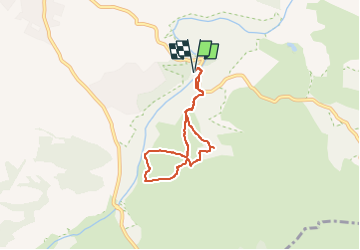
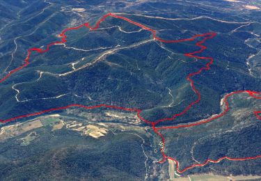
![](/images/other/stat-length.png)
![Trail Walking Vidauban - Tracé actuel: 04 MARS 2024 13:48 - Photo](https://media.geolcdn.com/t/1900/400/ext.pjpeg?maxdim=2&url=https%3A%2F%2Fstatic1.geolcdn.com%2Fsiteimages%2Fupload%2Ffiles%2F1553511878bg_sport_marche.png)
Tracé actuel: 04 MARS 2024 13:48
felix83
User
![Length](/images/other/stat-length.png)
![Max alt](https://static1.geolcdn.com/siteimages/upload/files/1508320355ic_sort_altitude_max_24dp.png)
![Uphill gradient](https://static1.geolcdn.com/siteimages/upload/files/1508320355ic_sort_den_pos_24dp.png)
![Km-Effort](/images/other/stat-length.png)
![Min alt](https://static1.geolcdn.com/siteimages/upload/files/1508320355ic_sort_altitude_min_24dp.png)
![Downhill gradient](https://static1.geolcdn.com/siteimages/upload/files/1508320355ic_sort_den_neg_24dp.png)
![Boucle](https://static1.geolcdn.com/siteimages/upload/files/16400158638029165_repeat_loop_refresh_sync_direction_icon.png)
![Walking](https://static1.geolcdn.com/sitytour/trail-icons/101.png)
1h25
Difficulty : Medium
![Scan this QR Code to open this trail in the SityTrail application](https://capi.geolives.com/qq0zvz2zws4bq2lad0pu/sitytour/trails/3970175/qr.png?size=200)
FREE GPS app for hiking
About
Trail Walking of 5.7 km to be discovered at Provence-Alpes-Côte d'Azur, Var, Vidauban. This trail is proposed by felix83.
Description
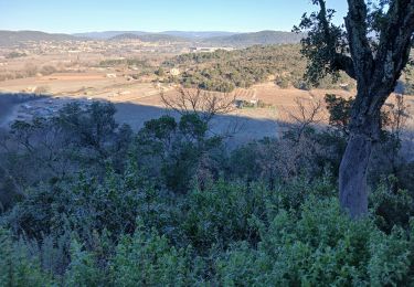
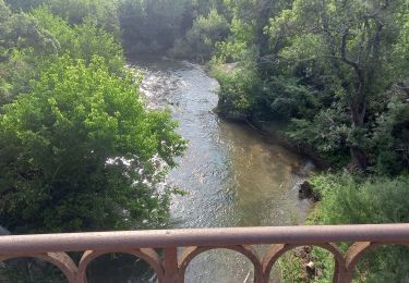
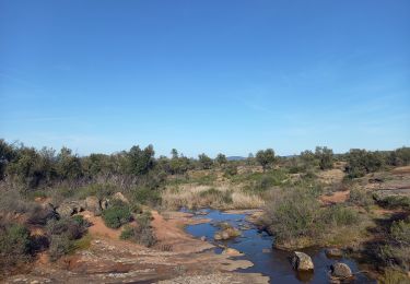
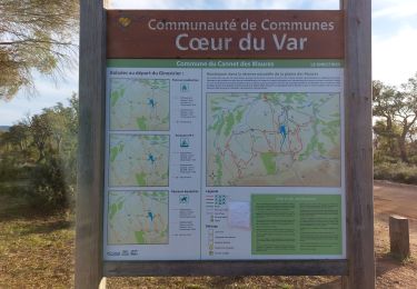
Petite randonnée dans la plaine des Maures sans difficulté. A ne pas faire avec un groupe le lendemain d'un orage en raison de nombreuses flaques. L'accès conseillé est par la route du Plan de la Tour. Attention, il ne faut pas se garer côté rivière car c'est considéré comme étant dans la réserve Naturelle (PV 135€) malgré l'absence de panneau d'interdiction. Côté droit il y a de nombreuses places.
Positioning
Comments
Trails nearby
![Trail Walking Les Arcs-sur-Argens - Trace_Les_Arcs - Photo](https://media.geolcdn.com/t/375/260/da020f46-e58f-416a-9a61-5f98a0302baf.jpg&format=jpg&maxdim=2)
![Walking Walking](https://static1.geolcdn.com/sitytour/trail-icons/101.png)
Walking
![](/images/other/stat-length.png)
![](https://static1.geolcdn.com/siteimages/upload/files/16400158638029165_repeat_loop_refresh_sync_direction_icon.png)
![Trail Walking Le Cannet-des-Maures - Palne des Maures - Photo](https://media.geolcdn.com/t/375/260/ext.jpg?maxdim=2&url=https%3A%2F%2Fservices.sitytrail.com%2FGeolivesWS%2FDownloadMedia.ashx%3FTrailID%3D844726%26Media%3D68613b80-dcb5-4229-b6f3-c522275e4d7f.JPG)
![Walking Walking](https://static1.geolcdn.com/sitytour/trail-icons/101.png)
Walking
![](/images/other/stat-length.png)
![](https://static1.geolcdn.com/siteimages/upload/files/16400158638029165_repeat_loop_refresh_sync_direction_icon.png)
![Trail Walking Vidauban - vidauban l'Aille - Photo](https://media.geolcdn.com/t/375/260/ext.jpg?maxdim=2&url=https%3A%2F%2Fstatic1.geolcdn.com%2Fsiteimages%2Fupload%2Ffiles%2F1553511878bg_sport_marche.png)
![Walking Walking](https://static1.geolcdn.com/sitytour/trail-icons/101.png)
Walking
![](/images/other/stat-length.png)
![](https://static1.geolcdn.com/siteimages/upload/files/16400158638029165_repeat_loop_refresh_sync_direction_icon.png)
![Trail Cycle Vidauban - Vidauban - Photo](https://media.geolcdn.com/t/375/260/ext.jpg?maxdim=2&url=https%3A%2F%2Fstatic1.geolcdn.com%2Fsiteimages%2Fupload%2Ffiles%2F1524743154velo.jpg)
![Cycle Cycle](https://static1.geolcdn.com/sitytour/trail-icons/200.png)
Cycle
![](/images/other/stat-length.png)
![](https://static1.geolcdn.com/siteimages/upload/files/16400158638029165_repeat_loop_refresh_sync_direction_icon.png)
![Trail Walking Les Arcs-sur-Argens - La colline de Cabredor les Arcs sur Argens, 17-01-2025 - Photo](https://media.geolcdn.com/t/375/260/3f2f9c21-31ed-48da-929f-286bae1564fc.jpg&format=jpg&maxdim=2)
![Walking Walking](https://static1.geolcdn.com/sitytour/trail-icons/101.png)
Walking
![](/images/other/stat-length.png)
![](https://static1.geolcdn.com/siteimages/upload/files/16400158638029165_repeat_loop_refresh_sync_direction_icon.png)
![Trail Walking Les Arcs-sur-Argens - Les Arcs Menhirs et Dolmen - Photo](https://media.geolcdn.com/t/375/260/5cd1c0e7-b5dd-4488-ac15-1c89d37aafb6.jpg&format=jpg&maxdim=2)
![Walking Walking](https://static1.geolcdn.com/sitytour/trail-icons/101.png)
Walking
![](/images/other/stat-length.png)
![](https://static1.geolcdn.com/siteimages/upload/files/16400158638029165_repeat_loop_refresh_sync_direction_icon.png)
![Trail Walking Les Arcs-sur-Argens - Les Arcs Menhirs et Dolmen - Photo](https://media.geolcdn.com/t/375/260/file:///storage/5427-3A6F/Android/data/com.geolives.apps.sitytrail.beta/files/ressources/captured_photos/20180713111205.jpg&format=jpg&maxdim=2)
![Walking Walking](https://static1.geolcdn.com/sitytour/trail-icons/101.png)
Walking
![](/images/other/stat-length.png)
![](https://static1.geolcdn.com/siteimages/upload/files/16400158638029165_repeat_loop_refresh_sync_direction_icon.png)
![Trail Walking Le Cannet-des-Maures - Lac des Escarcets 17.2.24 - Photo](https://media.geolcdn.com/t/375/260/f92ce486-bd5f-4ab3-9b40-d60a411549dd.jpg&format=jpg&maxdim=2)
![Walking Walking](https://static1.geolcdn.com/sitytour/trail-icons/101.png)
Walking
![](/images/other/stat-length.png)
![](https://static1.geolcdn.com/siteimages/upload/files/16400158638029165_repeat_loop_refresh_sync_direction_icon.png)
![Trail Walking Le Cannet-des-Maures - 20240121 Les Escarcets - Photo](https://media.geolcdn.com/t/375/260/9403a366-8794-4636-ad37-04f27a7fdf90.jpg&format=jpg&maxdim=2)
![Walking Walking](https://static1.geolcdn.com/sitytour/trail-icons/101.png)
Walking
![](/images/other/stat-length.png)
![](https://static1.geolcdn.com/siteimages/upload/files/16400158638029165_repeat_loop_refresh_sync_direction_icon.png)