![](/images/other/stat-length.png)
![Trail Walking La Bresse - La truche - Photo](https://media.geolcdn.com/t/1900/400/ext.pjpeg?maxdim=2&url=https%3A%2F%2Fstatic1.geolcdn.com%2Fsiteimages%2Fupload%2Ffiles%2F1553511878bg_sport_marche.png)
La truche
Baltykatt
User
![Length](/images/other/stat-length.png)
Length
10.6 km
![Max alt](https://static1.geolcdn.com/siteimages/upload/files/1508320355ic_sort_altitude_max_24dp.png)
Max alt
1049 m
![Uphill gradient](https://static1.geolcdn.com/siteimages/upload/files/1508320355ic_sort_den_pos_24dp.png)
Uphill gradient
350 m
![Km-Effort](/images/other/stat-length.png)
Km-Effort
15.3 km
![Min alt](https://static1.geolcdn.com/siteimages/upload/files/1508320355ic_sort_altitude_min_24dp.png)
Min alt
855 m
![Downhill gradient](https://static1.geolcdn.com/siteimages/upload/files/1508320355ic_sort_den_neg_24dp.png)
Downhill gradient
359 m
![Boucle](https://static1.geolcdn.com/siteimages/upload/files/16400158638029165_repeat_loop_refresh_sync_direction_icon.png)
Boucle
Yes
Creation date :
2024-03-03 12:34:10.418
Updated on :
2024-03-03 12:34:13.178
![Walking](https://static1.geolcdn.com/sitytour/trail-icons/101.png)
3h28
Difficulty : Medium
![Scan this QR Code to open this trail in the SityTrail application](https://capi.geolives.com/qq0zvz2zws4bq2lad0pu/sitytour/trails/3968591/qr.png?size=200)
FREE GPS app for hiking
About
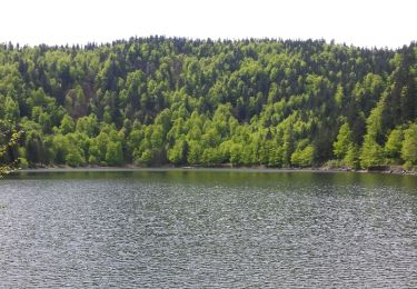
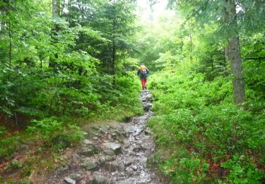
Trail Walking of 10.6 km to be discovered at Grand Est, Vosges, La Bresse. This trail is proposed by Baltykatt.
Description
Randonnée sur les hauteurs de la Bresse, vue sur la vallée, repas possible à l'auberge du Couchetat au retour et visite de la fermés des Lamas à proximité.
Positioning
Country:
France
Region :
Grand Est
Department/Province :
Vosges
Municipality :
La Bresse
Location:
Unknown
Start:(Dec)
Start:(UTM)
339699 ; 5319015 (32U) N.
Comments
Trails nearby
![Trail Walking La Bresse - Autour du Lac des Corbeaux - Photo](https://media.geolcdn.com/t/375/260/cc3388d0-b7b4-4b72-bf02-d3b5f6b4e910.jpg&format=jpg&maxdim=2)
![Walking Walking](https://static1.geolcdn.com/sitytour/trail-icons/101.png)
Autour du Lac des Corbeaux
Walking
Medium
(1)
La Bresse,
Grand Est,
Vosges,
France
![](/images/other/stat-length.png)
3.1 km | 6 km-effort
1h 30min
![](https://static1.geolcdn.com/siteimages/upload/files/16400158638029165_repeat_loop_refresh_sync_direction_icon.png)
Yes
![Trail Walking La Bresse - la bresse - le moutier des fées - Photo](https://media.geolcdn.com/t/375/260/8b05ded1-af8a-4cd0-8ffd-c8efb092f1de.jpg&format=jpg&maxdim=2)
![Walking Walking](https://static1.geolcdn.com/sitytour/trail-icons/101.png)
la bresse - le moutier des fées
Walking
Very easy
(1)
La Bresse,
Grand Est,
Vosges,
France
![](/images/other/stat-length.png)
26 km | 36 km-effort
3h 26min
![](https://static1.geolcdn.com/siteimages/upload/files/16400158638029165_repeat_loop_refresh_sync_direction_icon.png)
No
![Trail Walking La Bresse - SityTrail - Le Lac des Corbeaux - La Bresse - Photo](https://media.geolcdn.com/t/375/260/4efcd8bf-8367-405d-962e-dfceb2021e66.jpg&format=jpg&maxdim=2)
![Walking Walking](https://static1.geolcdn.com/sitytour/trail-icons/101.png)
SityTrail - Le Lac des Corbeaux - La Bresse
Walking
Very easy
(1)
La Bresse,
Grand Est,
Vosges,
France
![](/images/other/stat-length.png)
3 km | 6 km-effort
1h 0min
![](https://static1.geolcdn.com/siteimages/upload/files/16400158638029165_repeat_loop_refresh_sync_direction_icon.png)
Yes
![Trail Walking La Bresse - Le Couchetat - Photo](https://media.geolcdn.com/t/375/260/ext.jpg?maxdim=2&url=https%3A%2F%2Fservices.sitytrail.com%2FGeolivesWS%2FDownloadMedia.ashx%3FTrailID%3D441671%26Media%3D20150706110250.jpg)
![Walking Walking](https://static1.geolcdn.com/sitytour/trail-icons/101.png)
Le Couchetat
Walking
Very easy
(2)
La Bresse,
Grand Est,
Vosges,
France
![](/images/other/stat-length.png)
4.8 km | 7.4 km-effort
1h 50min
![](https://static1.geolcdn.com/siteimages/upload/files/16400158638029165_repeat_loop_refresh_sync_direction_icon.png)
Yes
![Trail Walking Cornimont - Xoulces _ Grand Ventron _ Vieille Montagne - Photo](https://media.geolcdn.com/t/375/260/ext.jpg?maxdim=2&url=https%3A%2F%2Fservices.sitytrail.com%2FGeolivesWS%2FDownloadMedia.ashx%3FTrailID%3D439822%26Media%3Dfix__20150630145857.jpg)
![Walking Walking](https://static1.geolcdn.com/sitytour/trail-icons/101.png)
Xoulces _ Grand Ventron _ Vieille Montagne
Walking
Medium
(1)
Cornimont,
Grand Est,
Vosges,
France
![](/images/other/stat-length.png)
15.6 km | 25 km-effort
5h 6min
![](https://static1.geolcdn.com/siteimages/upload/files/16400158638029165_repeat_loop_refresh_sync_direction_icon.png)
No
![Trail Mountain bike La Bresse - randonnée découverte à la Bresse. - Photo](https://media.geolcdn.com/t/375/260/ext.jpg?maxdim=2&url=https%3A%2F%2Fservices.sitytrail.com%2FGeolivesWS%2FDownloadMedia.ashx%3FTrailID%3D435768%26Media%3Dfix__20150620120320.jpg)
![Mountain bike Mountain bike](https://static1.geolcdn.com/sitytour/trail-icons/202.png)
randonnée découverte à la Bresse.
Mountain bike
Easy
(1)
La Bresse,
Grand Est,
Vosges,
France
![](/images/other/stat-length.png)
30 km | 41 km-effort
2h 58min
![](https://static1.geolcdn.com/siteimages/upload/files/16400158638029165_repeat_loop_refresh_sync_direction_icon.png)
Yes
![Trail Walking La Bresse - Le col du Brabant et le lac des Corbeaux - Photo](https://media.geolcdn.com/t/375/260/ext.jpg?maxdim=2&url=https%3A%2F%2Fservices.sitytrail.com%2FGeolivesWS%2FDownloadMedia.ashx%3FTrailID%3D418054%26Media%3Dfix__20150508123923.jpg)
![Walking Walking](https://static1.geolcdn.com/sitytour/trail-icons/101.png)
Le col du Brabant et le lac des Corbeaux
Walking
Medium
(2)
La Bresse,
Grand Est,
Vosges,
France
![](/images/other/stat-length.png)
10.3 km | 16.4 km-effort
3h 51min
![](https://static1.geolcdn.com/siteimages/upload/files/16400158638029165_repeat_loop_refresh_sync_direction_icon.png)
Yes
![Trail Walking La Bresse - Le Moutier des Fées_backup_backup - Photo](https://media.geolcdn.com/t/375/260/ext.jpg?maxdim=2&url=https%3A%2F%2Fstatic1.geolcdn.com%2Fsiteimages%2Fupload%2Ffiles%2F1553511878bg_sport_marche.png)
![Walking Walking](https://static1.geolcdn.com/sitytour/trail-icons/101.png)
Le Moutier des Fées_backup_backup
Walking
Easy
(1)
La Bresse,
Grand Est,
Vosges,
France
![](/images/other/stat-length.png)
9.1 km | 15.4 km-effort
3h 11min
![](https://static1.geolcdn.com/siteimages/upload/files/16400158638029165_repeat_loop_refresh_sync_direction_icon.png)
Yes
![Trail Walking La Bresse - Le Lac des Corbeaux - La Bresse - Photo](https://media.geolcdn.com/t/375/260/ext.jpg?maxdim=2&url=https%3A%2F%2Fservices.sitytrail.com%2FGeolivesWS%2FDownloadMedia.ashx%3FTrailID%3D110287%26Media%3D5681_2.jpg)
![Walking Walking](https://static1.geolcdn.com/sitytour/trail-icons/101.png)
Le Lac des Corbeaux - La Bresse
Walking
Medium
(2)
La Bresse,
Grand Est,
Vosges,
France
![](/images/other/stat-length.png)
3 km | 6 km-effort
2h 0min
![](https://static1.geolcdn.com/siteimages/upload/files/16400158638029165_repeat_loop_refresh_sync_direction_icon.png)
Yes