![](/images/other/stat-length.png)
![Trail Electric bike Aix-les-Bains - Aix les bains tour lac de Bourget abbaye Hautecombes - Photo](https://media.geolcdn.com/t/1900/400/6de4fae3-0815-4d48-bb94-d895cfa7b1bb.jpg&format=pjpeg&maxdim=2)
Aix les bains tour lac de Bourget abbaye Hautecombes
antignacs
User GUIDE
![Length](/images/other/stat-length.png)
Length
66 km
![Max alt](https://static1.geolcdn.com/siteimages/upload/files/1508320355ic_sort_altitude_max_24dp.png)
Max alt
886 m
![Uphill gradient](https://static1.geolcdn.com/siteimages/upload/files/1508320355ic_sort_den_pos_24dp.png)
Uphill gradient
1432 m
![Km-Effort](/images/other/stat-length.png)
Km-Effort
85 km
![Min alt](https://static1.geolcdn.com/siteimages/upload/files/1508320355ic_sort_altitude_min_24dp.png)
Min alt
228 m
![Downhill gradient](https://static1.geolcdn.com/siteimages/upload/files/1508320355ic_sort_den_neg_24dp.png)
Downhill gradient
1433 m
![Boucle](https://static1.geolcdn.com/siteimages/upload/files/16400158638029165_repeat_loop_refresh_sync_direction_icon.png)
Boucle
Yes
Creation date :
2024-02-29 08:36:09.0
Updated on :
2024-02-29 18:20:33.109
![Electric bike](https://static1.geolcdn.com/sitytour/trail-icons/205.png)
5h08
Difficulty : Medium
![Scan this QR Code to open this trail in the SityTrail application](https://capi.geolives.com/qq0zvz2zws4bq2lad0pu/sitytour/trails/3966104/qr.png?size=200)
FREE GPS app for hiking
About
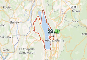
Trail Electric bike of 66 km to be discovered at Auvergne-Rhône-Alpes, Savoy, Aix-les-Bains. This trail is proposed by antignacs.
Description
oubli de remise en route sitytrail entre abbaye et chaudieu, on a bien sur pris la route.
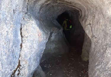
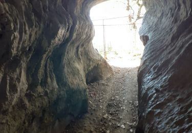
le dénivelé doit être en fait d'environ 1000 mètres car on a pris le tunnel (pour vélos) du Chat
au total super tour et belle abbaye
Positioning
Country:
France
Region :
Auvergne-Rhône-Alpes
Department/Province :
Savoy
Municipality :
Aix-les-Bains
Location:
Unknown
Start:(Dec)
Start:(UTM)
726592 ; 5065125 (31T) N.
Comments
Trails nearby
![Trail Walking Brison-Saint-Innocent - La Croix de Meyrieu, retour par la Grotte des Fées, depuis les Combes - Photo](https://media.geolcdn.com/t/375/260/ext.jpg?maxdim=2&url=https%3A%2F%2Fservices.sitytrail.com%2FGeolivesWS%2FDownloadMedia.ashx%3FTrailID%3D317495%26Media%3D16730_1.jpg)
![Walking Walking](https://static1.geolcdn.com/sitytour/trail-icons/101.png)
La Croix de Meyrieu, retour par la Grotte des Fées, depuis les Combes
Walking
Easy
(2)
Brison-Saint-Innocent,
Auvergne-Rhône-Alpes,
Savoy,
France
![](/images/other/stat-length.png)
8.5 km | 14.8 km-effort
3h 30min
![](https://static1.geolcdn.com/siteimages/upload/files/16400158638029165_repeat_loop_refresh_sync_direction_icon.png)
Yes
![Trail Mountain bike Aix-les-Bains - Randolac 2008 - Epine Chat Chambotte - Photo](https://media.geolcdn.com/t/375/260/ext.jpg?maxdim=2&url=https%3A%2F%2Fservices.sitytrail.com%2FGeolivesWS%2FDownloadMedia.ashx%3FTrailID%3D102831%26Media%3D3994_2.jpg)
![Mountain bike Mountain bike](https://static1.geolcdn.com/sitytour/trail-icons/202.png)
Randolac 2008 - Epine Chat Chambotte
Mountain bike
Very difficult
(1)
Aix-les-Bains,
Auvergne-Rhône-Alpes,
Savoy,
France
![](/images/other/stat-length.png)
64 km | 94 km-effort
7h 0min
![](https://static1.geolcdn.com/siteimages/upload/files/16400158638029165_repeat_loop_refresh_sync_direction_icon.png)
Yes
![Trail Walking Brison-Saint-Innocent - Grotte des fées, Croix de Meyrieu, Mont Corsuet 843m 1.7.24 - Photo](https://media.geolcdn.com/t/375/260/40c03b1e-7ecc-48c9-b0a4-5c8c250e48e1.jpg&format=jpg&maxdim=2)
![Walking Walking](https://static1.geolcdn.com/sitytour/trail-icons/101.png)
Grotte des fées, Croix de Meyrieu, Mont Corsuet 843m 1.7.24
Walking
Medium
Brison-Saint-Innocent,
Auvergne-Rhône-Alpes,
Savoy,
France
![](/images/other/stat-length.png)
13.5 km | 22 km-effort
4h 30min
![](https://static1.geolcdn.com/siteimages/upload/files/16400158638029165_repeat_loop_refresh_sync_direction_icon.png)
Yes
![Trail Walking Mouxy - Sentier du Perthuiset - Photo](https://media.geolcdn.com/t/375/260/ext.jpg?maxdim=2&url=https%3A%2F%2Fstatic1.geolcdn.com%2Fsiteimages%2Fupload%2Ffiles%2F1553511878bg_sport_marche.png)
![Walking Walking](https://static1.geolcdn.com/sitytour/trail-icons/101.png)
Sentier du Perthuiset
Walking
Medium
(1)
Mouxy,
Auvergne-Rhône-Alpes,
Savoy,
France
![](/images/other/stat-length.png)
9.4 km | 19.9 km-effort
3h 19min
![](https://static1.geolcdn.com/siteimages/upload/files/16400158638029165_repeat_loop_refresh_sync_direction_icon.png)
Yes
![Trail Via ferrata La Chapelle-du-Mont-du-Chat - 2011-04-03 via ferrata Col du chat - Photo](https://media.geolcdn.com/t/375/260/ext.jpg?maxdim=2&url=https%3A%2F%2Fstatic1.geolcdn.com%2Fsiteimages%2Fupload%2Ffiles%2F1545311037marcheuse_200dpi.jpg)
![Via ferrata Via ferrata](https://static1.geolcdn.com/sitytour/trail-icons/902.png)
2011-04-03 via ferrata Col du chat
Via ferrata
Easy
(1)
La Chapelle-du-Mont-du-Chat,
Auvergne-Rhône-Alpes,
Savoy,
France
![](/images/other/stat-length.png)
3.6 km | 6.8 km-effort
Unknown
![](https://static1.geolcdn.com/siteimages/upload/files/16400158638029165_repeat_loop_refresh_sync_direction_icon.png)
No
![Trail sport Aix-les-Bains - Colline du poète - Photo](https://media.geolcdn.com/t/375/260/52193566-3029-4655-87e0-73eaaebe11d3.jpg&format=jpg&maxdim=2)
Colline du poète
sport
Very easy
Aix-les-Bains,
Auvergne-Rhône-Alpes,
Savoy,
France
![](/images/other/stat-length.png)
7.5 km | 9.5 km-effort
Unknown
![](https://static1.geolcdn.com/siteimages/upload/files/16400158638029165_repeat_loop_refresh_sync_direction_icon.png)
Yes
![Trail Walking La Chapelle-du-Mont-du-Chat - 270523 Tour et Dent du Chat - Photo](https://media.geolcdn.com/t/375/260/0a1b231b-4827-4287-a183-6427b560c2c1.jpg&format=jpg&maxdim=2)
![Walking Walking](https://static1.geolcdn.com/sitytour/trail-icons/101.png)
270523 Tour et Dent du Chat
Walking
Easy
La Chapelle-du-Mont-du-Chat,
Auvergne-Rhône-Alpes,
Savoy,
France
![](/images/other/stat-length.png)
10 km | 21 km-effort
4h 15min
![](https://static1.geolcdn.com/siteimages/upload/files/16400158638029165_repeat_loop_refresh_sync_direction_icon.png)
Yes
![Trail Walking Brison-Saint-Innocent - GROTTE AUX FEES-G2-19-09-22 - Photo](https://media.geolcdn.com/t/375/260/f1bb9a19-fbf4-4d2b-9025-a3ae7cc879bf.jpg&format=jpg&maxdim=2)
![Walking Walking](https://static1.geolcdn.com/sitytour/trail-icons/101.png)
GROTTE AUX FEES-G2-19-09-22
Walking
Medium
Brison-Saint-Innocent,
Auvergne-Rhône-Alpes,
Savoy,
France
![](/images/other/stat-length.png)
5.6 km | 9.5 km-effort
2h 8min
![](https://static1.geolcdn.com/siteimages/upload/files/16400158638029165_repeat_loop_refresh_sync_direction_icon.png)
Yes
![Trail Walking Brison-Saint-Innocent - GROTTE AUX FEES-G1-19-09-22 - Photo](https://media.geolcdn.com/t/375/260/df3d3e15-ba52-43c1-9e78-06013c8469e1.jpg&format=jpg&maxdim=2)
![Walking Walking](https://static1.geolcdn.com/sitytour/trail-icons/101.png)
GROTTE AUX FEES-G1-19-09-22
Walking
Difficult
Brison-Saint-Innocent,
Auvergne-Rhône-Alpes,
Savoy,
France
![](/images/other/stat-length.png)
7.7 km | 12.5 km-effort
2h 50min
![](https://static1.geolcdn.com/siteimages/upload/files/16400158638029165_repeat_loop_refresh_sync_direction_icon.png)
Yes