![](/images/other/stat-length.png)
![Trail On foot Colognac - 30 du Cayrel au Camp Barrat 20/02/24 - Photo](https://media.geolcdn.com/t/1900/400/db46be15-0ade-41ce-a4c3-6381b880347f.jpg&format=pjpeg&maxdim=2)
30 du Cayrel au Camp Barrat 20/02/24
silvestreclaudine
User
![Length](/images/other/stat-length.png)
![Max alt](https://static1.geolcdn.com/siteimages/upload/files/1508320355ic_sort_altitude_max_24dp.png)
![Uphill gradient](https://static1.geolcdn.com/siteimages/upload/files/1508320355ic_sort_den_pos_24dp.png)
![Km-Effort](/images/other/stat-length.png)
![Min alt](https://static1.geolcdn.com/siteimages/upload/files/1508320355ic_sort_altitude_min_24dp.png)
![Downhill gradient](https://static1.geolcdn.com/siteimages/upload/files/1508320355ic_sort_den_neg_24dp.png)
![Boucle](https://static1.geolcdn.com/siteimages/upload/files/16400158638029165_repeat_loop_refresh_sync_direction_icon.png)
![On foot](https://static1.geolcdn.com/sitytour/trail-icons/100.png)
5h38
Difficulty : Medium
![Walking](https://static1.geolcdn.com/sitytour/trail-icons/101.png)
5h00
Difficulty : Very difficult
![Scan this QR Code to open this trail in the SityTrail application](https://capi.geolives.com/qq0zvz2zws4bq2lad0pu/sitytour/trails/3965924/qr.png?size=200)
FREE GPS app for hiking
About
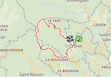
Trail On foot of 16 km to be discovered at Occitania, Gard, Colognac. This trail is proposed by silvestreclaudine.
Description
Attention ce circuit demande une bonne aptitude à la randonnée, je le déconseille aux personnes n'ayant pas les moyens de se localiser précisément.
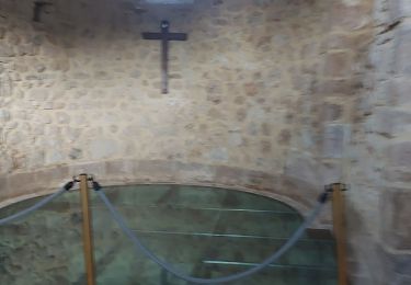
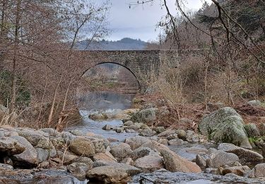
Départ de Colognac, se diriger vers le village, en restant sur la route de gauche (D 153). Après avoir traversé le pont du Gal, partir à droite en suivant un muret sous la ferme. Le sentier s'élève dans une châtaigneraie au fond du vallon, lorsqu'on aperçoit une petite cascade, le sentier quitte le vallon et monte sur la droite.
Nous arrivons sur un chemin goudronné, prendre à gauche, rester sur la partie asphaltée, abandonner la route de droite qui monte. Après environ 200 m au niveau du chemin d'une maison à gauche, partir à droite sur le sentier qui monte dans la forêt. On rejoint ensuite un sentier (balisage jaune), partir à droite et suivre jusqu'au hameau d'Alary.
Traverser le village. A la dernière maison le sentier quitte la route et monte à droite (balisage jaune). Le sentier se termine par un passage un peu délicat (éboulis de roches granitiques).
On débouche sur un chemin carossable. Partir à gauche sur 300m. au niveau de la bergerie (tunnel bâché de vert) continuer tout droit vers un abreuvoir, puis traverser un petit cours d'eau. Le sentier monte, il est peu visible au départ, il se trouve à droite au niveau des rochers, et monte à travers des fougères.
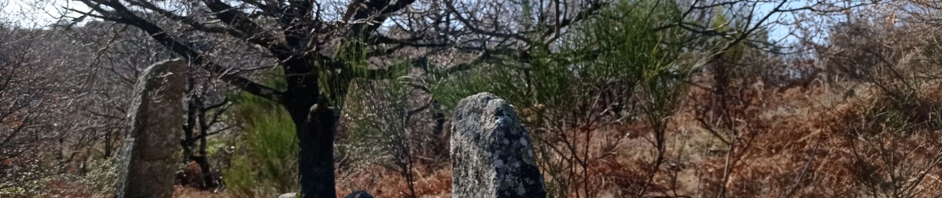
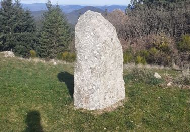
Au col, un jalon Indique des menhirs sur la gauche en montant, c'est un aller-retour de 10mn.
Retour au jalon, monter directement sur le sommet du Cayrel. Le sentier est peu visible, parfois des cairns, on passe près d'un poste de chasse, le sommet est à 971m, il est indiqué par un gros cairn. La vue par temps clair permet de voir : pic d'Anjeau, Mont Aigoual, Mont Lozère, Tanargue, Mont Ventoux, et la mer.
Redescendre par le même sentier.
Retour au jalon, puis partir à droite vers le col des fosses.
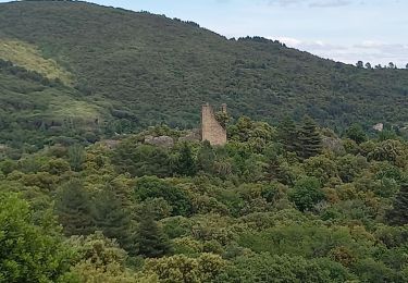
Au col des fosses, partir tout droit vers le Camp Barrat, le chemin passe près d'un gîte, montée caillouteuse.
Camp Barrat : suivre le jalon qui indique Colognac, partir tout droit, en suivant un reste de mur. Au bout du champ partir à droite pour trouver la descente. Après environ 30 mn, lorsque le sentier remonte un peu, partir à droite après les gros rochers, attention le sentier est peu visible, parfois des cairns, c'est une longue descente.
On rejoint un sentier bien marqué : partir à gauche. Il traverse un hameau en ruine, le Picard. A l'intersection prendre à droite vers la fromagerie la Poujade (vente pélardons).
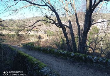
Continuer à descendre en partant sur le chemin de droite. Après le pont, le chemin remonte à Colognac.
Traverser le village (balisage jaune) jusqu'au parking.
Positioning
Comments
Trails nearby
![Trail Walking Lasalle - Lasalle (la Salendrinque) - Photo](https://media.geolcdn.com/t/375/260/ext.jpg?maxdim=2&url=https%3A%2F%2Fstatic1.geolcdn.com%2Fsiteimages%2Fupload%2Ffiles%2F1553511878bg_sport_marche.png)
![Walking Walking](https://static1.geolcdn.com/sitytour/trail-icons/101.png)
Walking
![](/images/other/stat-length.png)
![](https://static1.geolcdn.com/siteimages/upload/files/16400158638029165_repeat_loop_refresh_sync_direction_icon.png)
![Trail Walking Soudorgues - Vallée Salindrenque - Photo](https://media.geolcdn.com/t/375/260/cdaa973a-fc3c-410e-b572-e43390419aac.jpg&format=jpg&maxdim=2)
![Walking Walking](https://static1.geolcdn.com/sitytour/trail-icons/101.png)
Walking
![](/images/other/stat-length.png)
![](https://static1.geolcdn.com/siteimages/upload/files/16400158638029165_repeat_loop_refresh_sync_direction_icon.png)
![Trail Walking Lasalle - LASALLE - SAINTE-CROIX-DE-CADERLE – CALVIAC - 8.3Km - 02h30 - Dénivelé 352 m - Photo](https://media.geolcdn.com/t/375/260/ext.jpg?maxdim=2&url=https%3A%2F%2Fstatic1.geolcdn.com%2Fsiteimages%2Fupload%2Ffiles%2F1553511878bg_sport_marche.png)
![Walking Walking](https://static1.geolcdn.com/sitytour/trail-icons/101.png)
Walking
![](/images/other/stat-length.png)
![](https://static1.geolcdn.com/siteimages/upload/files/16400158638029165_repeat_loop_refresh_sync_direction_icon.png)
![Trail Walking Soudorgues - 30 le mauripe 12/01/25 - Photo](https://media.geolcdn.com/t/375/260/c58da66e-da90-432e-9b8e-79a3a5c374cc.jpg&format=jpg&maxdim=2)
![Walking Walking](https://static1.geolcdn.com/sitytour/trail-icons/101.png)
Walking
![](/images/other/stat-length.png)
![](https://static1.geolcdn.com/siteimages/upload/files/16400158638029165_repeat_loop_refresh_sync_direction_icon.png)
![Trail Walking Sainte-Croix-de-Caderle - Sainte croix de caderne - Photo](https://media.geolcdn.com/t/375/260/ba9120ca-f6c8-4e17-a730-5e8fa60dbcd0.jpg&format=jpg&maxdim=2)
![Walking Walking](https://static1.geolcdn.com/sitytour/trail-icons/101.png)
Walking
![](/images/other/stat-length.png)
![](https://static1.geolcdn.com/siteimages/upload/files/16400158638029165_repeat_loop_refresh_sync_direction_icon.png)
![Trail Walking Lasalle - Lasalle - Photo](https://media.geolcdn.com/t/375/260/f5798f1a-39ae-4247-a0e3-4c9a96cfa841.jpg&format=jpg&maxdim=2)
![Walking Walking](https://static1.geolcdn.com/sitytour/trail-icons/101.png)
![Trail Walking Lasalle - LaSalle - Photo](https://media.geolcdn.com/t/375/260/7a654ce7-e102-4459-8e43-06423b1a0861.jpg&format=jpg&maxdim=2)
![Walking Walking](https://static1.geolcdn.com/sitytour/trail-icons/101.png)
![Trail Walking Lasalle - vallée Salindrenque autour de Lasalle - Photo](https://media.geolcdn.com/t/375/260/a73dda74-f27d-4781-8977-cf2b7ac09d72.jpg&format=jpg&maxdim=2)
![Walking Walking](https://static1.geolcdn.com/sitytour/trail-icons/101.png)
Walking
![](/images/other/stat-length.png)
![](https://static1.geolcdn.com/siteimages/upload/files/16400158638029165_repeat_loop_refresh_sync_direction_icon.png)
![Trail Walking Saint-Roman-de-Codières - st roman de codieres - Photo](https://media.geolcdn.com/t/375/260/20d79857-0660-4ad5-8bfa-f1464b2570fb.jpg&format=jpg&maxdim=2)
![Walking Walking](https://static1.geolcdn.com/sitytour/trail-icons/101.png)
Walking
![](/images/other/stat-length.png)
![](https://static1.geolcdn.com/siteimages/upload/files/16400158638029165_repeat_loop_refresh_sync_direction_icon.png)