Trail Walking Esprels - le prieuré de Marast et le Lauzin - Photo

le prieuré de Marast et le Lauzin

© OpenStreetMap contributors
Length
Length
11.5 km
Max alt
Max alt
347 m
Uphill gradient
Uphill gradient
185 m
Km-Effort
Km-Effort  
13.9 km
Min alt
Min alt
258 m
Downhill gradient
Downhill gradient
187 m
Boucle
Boucle
Yes
Creation date :
2018-09-29 20:52:33.72
Updated on :
2018-09-29 20:52:33.739

(0 Reviews)

Walking
Walking
2h57
Difficulty : Medium

Scan this QR Code to open this trail in the SityTrail application

FREE GPS app for hiking

Logo SityTrail SityTrail

IGN / Geographical institutes

Download SityTrail from the App Store Download SityTrail from Google Play

Logo SityTrail SityTrail World

The world is yours!

Download SityTrail from the App Store Download SityTrail from Google Play Download SityTrail on Huawei AppGallery

About

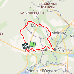
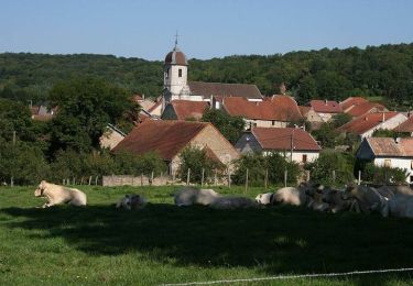
Trail Walking of 11.5 km to be discovered at Bourgogne-Franche-Comté, Haute-Saône, Esprels. This trail is proposed by nicolasdresse.

Description

Départ de la mairie d esprels à 20 km au sud est de vesoul par la D9.

Elevation profile

Positioning

Country:
France
Region :
Bourgogne-Franche-Comté
Department/Province :
Haute-Saône
Municipality :
Esprels
Location:
Unknown
Start:(UTM)
302266 ; 5268150 (32T) N.

Trails nearby

Trail Mountain bike Chassey-lès-Montbozon - Bonnal, piste cyclable en famille.  - Photo
Mountain bike
Raphaël K

Mountain bike

Medium
Chassey-lès-Montbozon, Bourgogne-Franche-Comté, Haute-Saône, France
20 km | 23 km-effort
1h 31min
No
Trail Mountain bike Moimay - Oricourt et environs - Photo
Mountain bike
Raphaël K

Mountain bike

Very difficult
Moimay, Bourgogne-Franche-Comté, Haute-Saône, France
40 km | 49 km-effort
3h 0min
No
Trail Walking Esprels - esprels - Photo
Walking
eltonnermou

Walking

Easy
Esprels, Bourgogne-Franche-Comté, Haute-Saône, France
13.8 km | 16.9 km-effort
2h 9min
Yes
Trail Walking Chassey-lès-Montbozon - Chassey les Montbozon  9 janv 2020 CAF - Photo
Walking
TRIMAILLE

Walking

Difficult
Chassey-lès-Montbozon, Bourgogne-Franche-Comté, Haute-Saône, France
24 km | 31 km-effort
6h 53min
Yes
Trail Cycle Villersexel - Boucle des Monts de l'Ognon (Variante) - Villersexel  - Photo
Cycle
tracegps

Cycle

Difficult
Villersexel, Bourgogne-Franche-Comté, Haute-Saône, France
40 km | 47 km-effort
1h 49min
Yes
Trail Walking Marast - Estrets-Vy les filain - Photo
Walking
dagobert5612

Walking

Very easy
Marast, Bourgogne-Franche-Comté, Haute-Saône, France
19.1 km | 23 km-effort
5h 50min
No
Trail 4x4 Villersexel - Mercredi 03 transversale  - Photo
4x4
eldingue

4x4

Villersexel, Bourgogne-Franche-Comté, Haute-Saône, France
153 km | 183 km-effort
6h 19min
No
Trail Walking Villersexel - monument des cosaques  - Photo
Walking
nicolasdresse

Walking

Easy
Villersexel, Bourgogne-Franche-Comté, Haute-Saône, France
8.2 km | 10 km-effort
2h 6min
Yes
Trail Walking Esprels - Esprel - Photo
Walking
cassotti

Walking

Difficult
Esprels, Bourgogne-Franche-Comté, Haute-Saône, France
12.7 km | 15.9 km-effort
2h 59min
Yes


Close
My subscriptions