![](/images/other/stat-length.png)
![Trail Walking Saint-Gor - St-gor - Photo](https://media.geolcdn.com/t/1900/400/ext.pjpeg?maxdim=2&url=https%3A%2F%2Fstatic1.geolcdn.com%2Fsiteimages%2Fupload%2Ffiles%2F1553511878bg_sport_marche.png)
St-gor
DuMarsan
User
![Length](/images/other/stat-length.png)
Length
7.6 km
![Max alt](https://static1.geolcdn.com/siteimages/upload/files/1508320355ic_sort_altitude_max_24dp.png)
Max alt
127 m
![Uphill gradient](https://static1.geolcdn.com/siteimages/upload/files/1508320355ic_sort_den_pos_24dp.png)
Uphill gradient
73 m
![Km-Effort](/images/other/stat-length.png)
Km-Effort
8.6 km
![Min alt](https://static1.geolcdn.com/siteimages/upload/files/1508320355ic_sort_altitude_min_24dp.png)
Min alt
98 m
![Downhill gradient](https://static1.geolcdn.com/siteimages/upload/files/1508320355ic_sort_den_neg_24dp.png)
Downhill gradient
74 m
![Boucle](https://static1.geolcdn.com/siteimages/upload/files/16400158638029165_repeat_loop_refresh_sync_direction_icon.png)
Boucle
Yes
Creation date :
2015-03-15 00:00:00.0
Updated on :
2015-03-15 00:00:00.0
![Walking](https://static1.geolcdn.com/sitytour/trail-icons/101.png)
1h20
Difficulty : Unknown
![Scan this QR Code to open this trail in the SityTrail application](https://capi.geolives.com/qq0zvz2zws4bq2lad0pu/sitytour/trails/396245/qr.png?size=200)
FREE GPS app for hiking
About
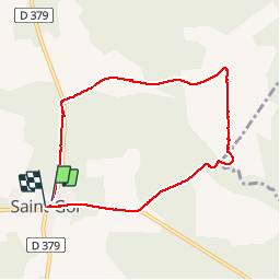
Trail Walking of 7.6 km to be discovered at New Aquitaine, Landes, Saint-Gor. This trail is proposed by DuMarsan.
Description
Randoguide 13.7 du conseil général des landes.
Rando sans grand intérêt ( beaucoup de route, des pins, un seul coin agréable autour du pont de Coharlanne.
La durée annoncée est très surestimée.( 1h20 sans forcer et non 2h30 !! )
Positioning
Country:
France
Region :
New Aquitaine
Department/Province :
Landes
Municipality :
Saint-Gor
Location:
Unknown
Start:(Dec)
Start:(UTM)
721012 ; 4881657 (30T) N.
Comments
Trails nearby
![Trail Walking Saint-Gor - saint gor - Photo](https://media.geolcdn.com/t/375/260/ext.jpg?maxdim=2&url=https%3A%2F%2Fstatic1.geolcdn.com%2Fsiteimages%2Fupload%2Ffiles%2F1553511878bg_sport_marche.png)
![Walking Walking](https://static1.geolcdn.com/sitytour/trail-icons/101.png)
saint gor
Walking
Medium
Saint-Gor,
New Aquitaine,
Landes,
France
![](/images/other/stat-length.png)
7.5 km | 8.4 km-effort
1h 48min
![](https://static1.geolcdn.com/siteimages/upload/files/16400158638029165_repeat_loop_refresh_sync_direction_icon.png)
Yes
![Trail Walking Arue - Boucle de Nabias - Photo](https://media.geolcdn.com/t/375/260/ext.jpg?maxdim=2&url=https%3A%2F%2Fstatic1.geolcdn.com%2Fsiteimages%2Fupload%2Ffiles%2F1553511878bg_sport_marche.png)
![Walking Walking](https://static1.geolcdn.com/sitytour/trail-icons/101.png)
Boucle de Nabias
Walking
Very easy
Arue,
New Aquitaine,
Landes,
France
![](/images/other/stat-length.png)
5.5 km | 6 km-effort
1h 52min
![](https://static1.geolcdn.com/siteimages/upload/files/16400158638029165_repeat_loop_refresh_sync_direction_icon.png)
Yes