![](/images/other/stat-length.png)
![Trail Walking Le Bouchet-Saint-Nicolas - Stevenson - Etape 3 - Photo](https://media.geolcdn.com/t/1900/400/ext.pjpeg?maxdim=2&url=https%3A%2F%2Fstatic1.geolcdn.com%2Fsiteimages%2Fupload%2Ffiles%2F1553511878bg_sport_marche.png)
Stevenson - Etape 3
nfranche
User
![Length](/images/other/stat-length.png)
Length
22 km
![Max alt](https://static1.geolcdn.com/siteimages/upload/files/1508320355ic_sort_altitude_max_24dp.png)
Max alt
1239 m
![Uphill gradient](https://static1.geolcdn.com/siteimages/upload/files/1508320355ic_sort_den_pos_24dp.png)
Uphill gradient
362 m
![Km-Effort](/images/other/stat-length.png)
Km-Effort
27 km
![Min alt](https://static1.geolcdn.com/siteimages/upload/files/1508320355ic_sort_altitude_min_24dp.png)
Min alt
985 m
![Downhill gradient](https://static1.geolcdn.com/siteimages/upload/files/1508320355ic_sort_den_neg_24dp.png)
Downhill gradient
430 m
![Boucle](https://static1.geolcdn.com/siteimages/upload/files/16400158638029165_repeat_loop_refresh_sync_direction_icon.png)
Boucle
No
Creation date :
2015-03-14 00:00:00.0
Updated on :
2015-03-14 00:00:00.0
![Walking](https://static1.geolcdn.com/sitytour/trail-icons/101.png)
5h42
Difficulty : Easy
![Scan this QR Code to open this trail in the SityTrail application](https://capi.geolives.com/qq0zvz2zws4bq2lad0pu/sitytour/trails/395771/qr.png?size=200)
FREE GPS app for hiking
About
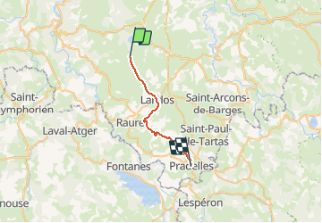
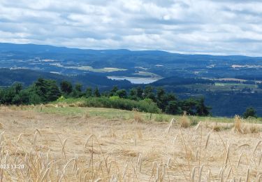
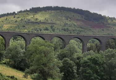
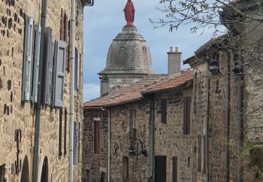
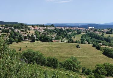
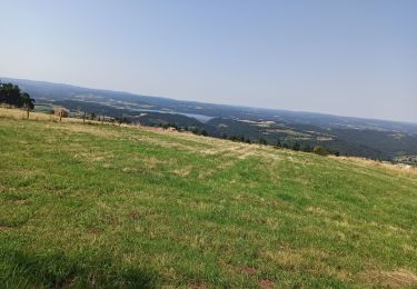
Trail Walking of 22 km to be discovered at Auvergne-Rhône-Alpes, Haute-Loire, Le Bouchet-Saint-Nicolas. This trail is proposed by nfranche.
Description
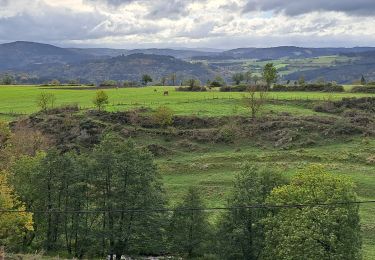
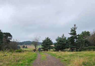
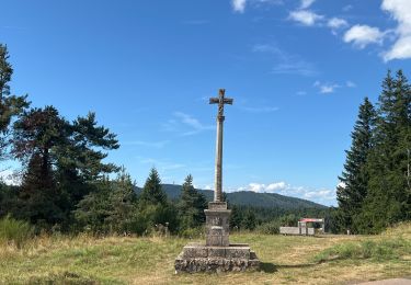
Le Bouchet St-Nicolas - Pradelles :Etape plus "cool" mais assez monotone et passablement bitumée ! Le chemin suit la vallée de l'Allier, à flanc de coteau.
Positioning
Country:
France
Region :
Auvergne-Rhône-Alpes
Department/Province :
Haute-Loire
Municipality :
Le Bouchet-Saint-Nicolas
Location:
Unknown
Start:(Dec)
Start:(UTM)
562279 ; 4971056 (31T) N.
Comments
Trails nearby
![Trail Walking Saint-Haon - le nouveau Monde - Photo](https://media.geolcdn.com/t/375/260/cca55de8-54d4-44a4-a902-d24b301019d1.jpg&format=jpg&maxdim=2)
![Walking Walking](https://static1.geolcdn.com/sitytour/trail-icons/101.png)
le nouveau Monde
Walking
Medium
Saint-Haon,
Auvergne-Rhône-Alpes,
Haute-Loire,
France
![](/images/other/stat-length.png)
9.1 km | 13.3 km-effort
2h 52min
![](https://static1.geolcdn.com/siteimages/upload/files/16400158638029165_repeat_loop_refresh_sync_direction_icon.png)
Yes
![Trail Walking Le Bouchet-Saint-Nicolas - STEVENSON Le Boucher St Nicolas à Pradelles - Photo](https://media.geolcdn.com/t/375/260/e589f375-fa46-4575-a377-24d61a2088b8.jpg&format=jpg&maxdim=2)
![Walking Walking](https://static1.geolcdn.com/sitytour/trail-icons/101.png)
STEVENSON Le Boucher St Nicolas à Pradelles
Walking
Easy
Le Bouchet-Saint-Nicolas,
Auvergne-Rhône-Alpes,
Haute-Loire,
France
![](/images/other/stat-length.png)
16 km | 19.4 km-effort
4h 24min
![](https://static1.geolcdn.com/siteimages/upload/files/16400158638029165_repeat_loop_refresh_sync_direction_icon.png)
No
![Trail Walking Cayres - Grand tour du Lac du Bouchet - Photo](https://media.geolcdn.com/t/375/260/6c5e80eb-92ec-4387-9dae-8b2160e14ba4.jpg&format=jpg&maxdim=2)
![Walking Walking](https://static1.geolcdn.com/sitytour/trail-icons/101.png)
Grand tour du Lac du Bouchet
Walking
Very easy
Cayres,
Auvergne-Rhône-Alpes,
Haute-Loire,
France
![](/images/other/stat-length.png)
5 km | 6.3 km-effort
1h 10min
![](https://static1.geolcdn.com/siteimages/upload/files/16400158638029165_repeat_loop_refresh_sync_direction_icon.png)
Yes
![Trail Walking Le Bouchet-Saint-Nicolas - Etape 2 Bouchet st Nicolas Pradelles - Photo](https://media.geolcdn.com/t/375/260/e26470b1-7d09-4c3c-b167-76eb852efcc5.jpg&format=jpg&maxdim=2)
![Walking Walking](https://static1.geolcdn.com/sitytour/trail-icons/101.png)
Etape 2 Bouchet st Nicolas Pradelles
Walking
Medium
Le Bouchet-Saint-Nicolas,
Auvergne-Rhône-Alpes,
Haute-Loire,
France
![](/images/other/stat-length.png)
23 km | 28 km-effort
5h 26min
![](https://static1.geolcdn.com/siteimages/upload/files/16400158638029165_repeat_loop_refresh_sync_direction_icon.png)
No
![Trail Walking Le Bouchet-Saint-Nicolas - Le Bouchet St Nicolas,Pradelle - Photo](https://media.geolcdn.com/t/375/260/831a6e71-aff7-41f0-8059-9cd2ff7041df.jpg&format=jpg&maxdim=2)
![Walking Walking](https://static1.geolcdn.com/sitytour/trail-icons/101.png)
Le Bouchet St Nicolas,Pradelle
Walking
Easy
Le Bouchet-Saint-Nicolas,
Auvergne-Rhône-Alpes,
Haute-Loire,
France
![](/images/other/stat-length.png)
22 km | 27 km-effort
6h 58min
![](https://static1.geolcdn.com/siteimages/upload/files/16400158638029165_repeat_loop_refresh_sync_direction_icon.png)
No
![Trail Walking Le Bouchet-Saint-Nicolas - 08-05-2023 E3 Le Bouchet Saint Nicolas - Langogne - Photo](https://media.geolcdn.com/t/375/260/8bb6a970-0785-4062-8d5d-6982f88c1225.jpg&format=jpg&maxdim=2)
![Walking Walking](https://static1.geolcdn.com/sitytour/trail-icons/101.png)
08-05-2023 E3 Le Bouchet Saint Nicolas - Langogne
Walking
Very difficult
(1)
Le Bouchet-Saint-Nicolas,
Auvergne-Rhône-Alpes,
Haute-Loire,
France
![](/images/other/stat-length.png)
27 km | 34 km-effort
7h 39min
![](https://static1.geolcdn.com/siteimages/upload/files/16400158638029165_repeat_loop_refresh_sync_direction_icon.png)
No
![Trail Walking Le Bouchet-Saint-Nicolas - pradelles - Photo](https://media.geolcdn.com/t/375/260/13ff9535-4401-4af3-86ba-708829cda2d7.jpg&format=jpg&maxdim=2)
![Walking Walking](https://static1.geolcdn.com/sitytour/trail-icons/101.png)
pradelles
Walking
Very difficult
Le Bouchet-Saint-Nicolas,
Auvergne-Rhône-Alpes,
Haute-Loire,
France
![](/images/other/stat-length.png)
21 km | 26 km-effort
5h 34min
![](https://static1.geolcdn.com/siteimages/upload/files/16400158638029165_repeat_loop_refresh_sync_direction_icon.png)
No
![Trail Mountain bike Le Bouchet-Saint-Nicolas - Bouchet - Le Cheylard 2020 - Photo](https://media.geolcdn.com/t/375/260/1abe87dd-eb0f-481e-98ff-920c0c7e3292.jpg&format=jpg&maxdim=2)
![Mountain bike Mountain bike](https://static1.geolcdn.com/sitytour/trail-icons/202.png)
Bouchet - Le Cheylard 2020
Mountain bike
Medium
Le Bouchet-Saint-Nicolas,
Auvergne-Rhône-Alpes,
Haute-Loire,
France
![](/images/other/stat-length.png)
49 km | 62 km-effort
5h 35min
![](https://static1.geolcdn.com/siteimages/upload/files/16400158638029165_repeat_loop_refresh_sync_direction_icon.png)
No
![Trail Walking Costaros - Regordane 1 - Costaros - Langogne - Photo](https://media.geolcdn.com/t/375/260/f30f32d2-fff1-4db2-aed8-32bcc4c3be75.jpg&format=jpg&maxdim=2)
![Walking Walking](https://static1.geolcdn.com/sitytour/trail-icons/101.png)
Regordane 1 - Costaros - Langogne
Walking
Medium
Costaros,
Auvergne-Rhône-Alpes,
Haute-Loire,
France
![](/images/other/stat-length.png)
27 km | 32 km-effort
7h 4min
![](https://static1.geolcdn.com/siteimages/upload/files/16400158638029165_repeat_loop_refresh_sync_direction_icon.png)
No