Trail Walking Aumont-en-Halatte - Aumont_Poteau d_Auteuil_Trace GPS simplifiée_10.1km - Photo

Aumont_Poteau d_Auteuil_Trace GPS simplifiée_10.1km

© OpenStreetMap contributors
Length
Length
9.8 km
Max alt
Max alt
147 m
Uphill gradient
Uphill gradient
129 m
Km-Effort
Km-Effort  
11.5 km
Min alt
Min alt
85 m
Downhill gradient
Downhill gradient
129 m
Boucle
Boucle
Yes
Creation date :
2015-03-14 00:00:00.0
Updated on :
2015-03-14 00:00:00.0

(0 Reviews)

Walking
Walking
2h51
Difficulty : Difficult

Scan this QR Code to open this trail in the SityTrail application

FREE GPS app for hiking

Logo SityTrail SityTrail

IGN / Geographical institutes

Download SityTrail from the App Store Download SityTrail from Google Play

Logo SityTrail SityTrail World

The world is yours!

Download SityTrail from the App Store Download SityTrail from Google Play Download SityTrail on Huawei AppGallery

About

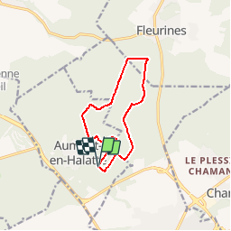
Trail Walking of 9.8 km to be discovered at Hauts-de-France, Oise, Aumont-en-Halatte. This trail is proposed by Pousscailleux.

Description

Départ du carrefour de la Queue de la Brosse.
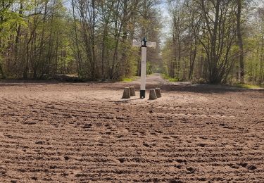
Beaucoup de sentiers très boueux, défoncés par les forestiers, à la limite du praticable.

Elevation profile

Positioning

Country:
France
Region :
Hauts-de-France
Department/Province :
Oise
Municipality :
Aumont-en-Halatte
Location:
Unknown
Start:(UTM)
468125 ; 5452670 (31U) N.

Trails nearby

Trail Walking Senlis - SM_ERMENONVILLE Mais Forest BIAT_7.9Km - Photo
Walking
GR77LP

Walking

Medium
(3)
Senlis, Hauts-de-France, Oise, France
7.9 km | 8.9 km-effort
2h 1min
Yes
Trail On foot Senlis - SENLIS CITE ROYALE(FFK) - Photo
On foot
GR77LP

On foot

Very easy
(1)
Senlis, Hauts-de-France, Oise, France
4.6 km | 5.2 km-effort
2h 0min
Yes
Trail Walking Fleurines - Fleurines Grand parcours - Photo
Walking
CC.RIDER

Walking

Easy
(1)
Fleurines, Hauts-de-France, Oise, France
20 km | 24 km-effort
5h 8min
Yes
Trail Walking Apremont - apremont 60300 - Photo
Walking
dartoisclaude

Walking

Difficult
(1)
Apremont, Hauts-de-France, Oise, France
20 km | 23 km-effort
4h 49min
Yes
Trail Walking Chamant - Chamant Supermini-rando - Photo
Walking
CC.RIDER

Walking

Easy
(8)
Chamant, Hauts-de-France, Oise, France
8 km | 9.3 km-effort
2h 7min
Yes
Trail On foot Senlis - De Orrouy à Coye - Photo
On foot
GUIDE+

On foot

Easy
Senlis, Hauts-de-France, Oise, France
10.1 km | 11.2 km-effort
2h 33min
No
Trail On foot Aumont-en-Halatte - Chemin Royal - Photo
On foot
GUIDE+

On foot

Easy
Aumont-en-Halatte, Hauts-de-France, Oise, France
3.5 km | 4 km-effort
54min
No
Trail Walking Avilly-Saint-Léonard - randonnée en forêt de chantilly - Photo
Walking
jumetz philippe

Walking

Very easy
Avilly-Saint-Léonard, Hauts-de-France, Oise, France
12.1 km | 13.2 km-effort
2h 54min
Yes
Trail Walking Fleurines - Fleurines_StChristophe_12,7 km_Trace GPS - Photo
Walking
Pousscailleux

Walking

Medium
(1)
Fleurines, Hauts-de-France, Oise, France
12.7 km | 15.6 km-effort
2h 42min
Yes


Close
My subscriptions