![](/images/other/stat-length.png)
![Trail Walking Le Val-d'Ajol - Le Val-d'Ajol (Faymont) 17 540m +508m - Photo](https://media.geolcdn.com/t/1900/400/ext.pjpeg?maxdim=2&url=https%3A%2F%2Fstatic1.geolcdn.com%2Fsiteimages%2Fupload%2Ffiles%2F1553511878bg_sport_marche.png)
Le Val-d'Ajol (Faymont) 17 540m +508m
DanielROLLET
User
![Length](/images/other/stat-length.png)
Length
17.5 km
![Max alt](https://static1.geolcdn.com/siteimages/upload/files/1508320355ic_sort_altitude_max_24dp.png)
Max alt
615 m
![Uphill gradient](https://static1.geolcdn.com/siteimages/upload/files/1508320355ic_sort_den_pos_24dp.png)
Uphill gradient
508 m
![Km-Effort](/images/other/stat-length.png)
Km-Effort
24 km
![Min alt](https://static1.geolcdn.com/siteimages/upload/files/1508320355ic_sort_altitude_min_24dp.png)
Min alt
354 m
![Downhill gradient](https://static1.geolcdn.com/siteimages/upload/files/1508320355ic_sort_den_neg_24dp.png)
Downhill gradient
507 m
![Boucle](https://static1.geolcdn.com/siteimages/upload/files/16400158638029165_repeat_loop_refresh_sync_direction_icon.png)
Boucle
Yes
Creation date :
2024-02-19 08:19:22.748
Updated on :
2024-02-19 18:17:00.868
![Walking](https://static1.geolcdn.com/sitytour/trail-icons/101.png)
5h31
Difficulty : Very difficult
![Scan this QR Code to open this trail in the SityTrail application](https://capi.geolives.com/qq0zvz2zws4bq2lad0pu/sitytour/trails/3955411/qr.png?size=200)
FREE GPS app for hiking
About
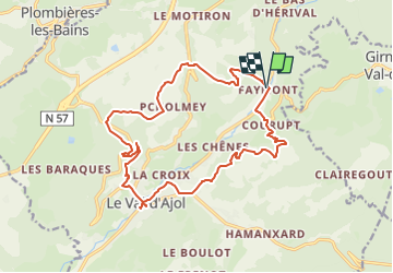
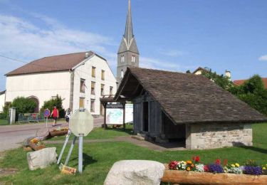
Trail Walking of 17.5 km to be discovered at Grand Est, Vosges, Le Val-d'Ajol. This trail is proposed by DanielROLLET.
Description
2024 02 19 - 9h25 à 15h15 - Avec Marie
Compris 1h à la foire aux andouilles au Val d'Ajol
Temps couvert et frais mais calme.
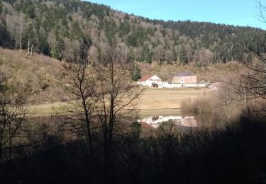
Belle balade variée
Pique-nique dans un bistrot au Val-d'Ajol
Positioning
Country:
France
Region :
Grand Est
Department/Province :
Vosges
Municipality :
Le Val-d'Ajol
Location:
Unknown
Start:(Dec)
Start:(UTM)
314972 ; 5313694 (32T) N.
Comments
Trails nearby
![Trail On foot Girmont-Val-d'Ajol - Les Étangs du Girmont - Photo](https://media.geolcdn.com/t/375/260/5b2df71d-978f-45ae-8b89-c03378f2d860.jpeg&format=jpg&maxdim=2)
![On foot On foot](https://static1.geolcdn.com/sitytour/trail-icons/100.png)
Les Étangs du Girmont
On foot
Easy
Girmont-Val-d'Ajol,
Grand Est,
Vosges,
France
![](/images/other/stat-length.png)
9.9 km | 13.1 km-effort
2h 59min
![](https://static1.geolcdn.com/siteimages/upload/files/16400158638029165_repeat_loop_refresh_sync_direction_icon.png)
Yes
![Trail Mountain bike Girmont-Val-d'Ajol - Rando de Che No 2013 - Photo](https://media.geolcdn.com/t/375/260/ext.jpg?maxdim=2&url=https%3A%2F%2Fstatic1.geolcdn.com%2Fsiteimages%2Fupload%2Ffiles%2F1524743154velo.jpg)
![Mountain bike Mountain bike](https://static1.geolcdn.com/sitytour/trail-icons/202.png)
Rando de Che No 2013
Mountain bike
Difficult
(1)
Girmont-Val-d'Ajol,
Grand Est,
Vosges,
France
![](/images/other/stat-length.png)
48 km | 63 km-effort
3h 59min
![](https://static1.geolcdn.com/siteimages/upload/files/16400158638029165_repeat_loop_refresh_sync_direction_icon.png)
Yes
![Trail Walking Girmont-Val-d'Ajol - Les Étangs de Girmont - Photo](https://media.geolcdn.com/t/375/260/711c3bcd-297e-44b0-ad6e-a1a73af41360.jpg&format=jpg&maxdim=2)
![Walking Walking](https://static1.geolcdn.com/sitytour/trail-icons/101.png)
Les Étangs de Girmont
Walking
Easy
Girmont-Val-d'Ajol,
Grand Est,
Vosges,
France
![](/images/other/stat-length.png)
8 km | 10.6 km-effort
2h 8min
![](https://static1.geolcdn.com/siteimages/upload/files/16400158638029165_repeat_loop_refresh_sync_direction_icon.png)
Yes
![Trail Walking Le Val-d'Ajol - Cascade de Faymont - Photo](https://media.geolcdn.com/t/375/260/213786ee-7982-426a-8a56-d635bef7e711.jpg&format=jpg&maxdim=2)
![Walking Walking](https://static1.geolcdn.com/sitytour/trail-icons/101.png)
Cascade de Faymont
Walking
Easy
Le Val-d'Ajol,
Grand Est,
Vosges,
France
![](/images/other/stat-length.png)
9.7 km | 13.7 km-effort
2h 44min
![](https://static1.geolcdn.com/siteimages/upload/files/16400158638029165_repeat_loop_refresh_sync_direction_icon.png)
Yes
![Trail Walking La Montagne - la montagne 70000 - Photo](https://media.geolcdn.com/t/375/260/14a55937-fdd9-43ce-b4ae-5478c59489e1.jpg&format=jpg&maxdim=2)
![Walking Walking](https://static1.geolcdn.com/sitytour/trail-icons/101.png)
la montagne 70000
Walking
Very difficult
La Montagne,
Bourgogne-Franche-Comté,
Haute-Saône,
France
![](/images/other/stat-length.png)
17.2 km | 23 km-effort
5h 3min
![](https://static1.geolcdn.com/siteimages/upload/files/16400158638029165_repeat_loop_refresh_sync_direction_icon.png)
No
![Trail Walking Girmont-Val-d'Ajol - 24-02-19 girmont - Photo](https://media.geolcdn.com/t/375/260/ext.jpg?maxdim=2&url=https%3A%2F%2Fservices.sitytrail.com%2FGeolivesWS%2FDownloadMedia.ashx%3FTrailID%3D1115683%26Media%3Dfix__20190224152844.jpg)
![Walking Walking](https://static1.geolcdn.com/sitytour/trail-icons/101.png)
24-02-19 girmont
Walking
Medium
Girmont-Val-d'Ajol,
Grand Est,
Vosges,
France
![](/images/other/stat-length.png)
10.8 km | 15.4 km-effort
2h 35min
![](https://static1.geolcdn.com/siteimages/upload/files/16400158638029165_repeat_loop_refresh_sync_direction_icon.png)
Yes
![Trail Snowshoes La Montagne - raquettes st bresson 14-01-17 - Photo](https://media.geolcdn.com/t/375/260/ext.jpg?maxdim=2&url=https%3A%2F%2Fservices.sitytrail.com%2FGeolivesWS%2FDownloadMedia.ashx%3FTrailID%3D684393%26Media%3Dfix__20170114160616.jpg)
![Snowshoes Snowshoes](https://static1.geolcdn.com/sitytour/trail-icons/504.png)
raquettes st bresson 14-01-17
Snowshoes
Easy
La Montagne,
Bourgogne-Franche-Comté,
Haute-Saône,
France
![](/images/other/stat-length.png)
4.6 km | 5.9 km-effort
1h 36min
![](https://static1.geolcdn.com/siteimages/upload/files/16400158638029165_repeat_loop_refresh_sync_direction_icon.png)
Yes
![Trail Walking Girmont-Val-d'Ajol - Les Sources du Rey - Girmont Val d'Ajol - Photo](https://media.geolcdn.com/t/375/260/ext.jpg?maxdim=2&url=https%3A%2F%2Fservices.sitytrail.com%2FGeolivesWS%2FDownloadMedia.ashx%3FTrailID%3D109896%26Media%3D4903_5.jpg)
![Walking Walking](https://static1.geolcdn.com/sitytour/trail-icons/101.png)
Les Sources du Rey - Girmont Val d'Ajol
Walking
Difficult
Girmont-Val-d'Ajol,
Grand Est,
Vosges,
France
![](/images/other/stat-length.png)
13.3 km | 18.5 km-effort
4h 0min
![](https://static1.geolcdn.com/siteimages/upload/files/16400158638029165_repeat_loop_refresh_sync_direction_icon.png)
Yes
![Trail Walking Girmont-Val-d'Ajol - 01-01-25 circuit des étangs Girmont-val- d'Ajol - Photo](https://media.geolcdn.com/t/375/260/a85162f2-0765-4402-871c-c4bfcf61e826.jpg&format=jpg&maxdim=2)
![Walking Walking](https://static1.geolcdn.com/sitytour/trail-icons/101.png)
01-01-25 circuit des étangs Girmont-val- d'Ajol
Walking
Easy
Girmont-Val-d'Ajol,
Grand Est,
Vosges,
France
![](/images/other/stat-length.png)
8.3 km | 10.9 km-effort
1h 58min
![](https://static1.geolcdn.com/siteimages/upload/files/16400158638029165_repeat_loop_refresh_sync_direction_icon.png)
Yes