![](/images/other/stat-length.png)
![Trail Walking Beure - Beure de la pisseur au mercureau - Photo](https://media.geolcdn.com/t/1900/400/af87c349-0861-4e70-9a13-b157a632bd51.jpg&format=pjpeg&maxdim=2)
Beure de la pisseur au mercureau
eltonnermou
User
![Length](/images/other/stat-length.png)
![Max alt](https://static1.geolcdn.com/siteimages/upload/files/1508320355ic_sort_altitude_max_24dp.png)
![Uphill gradient](https://static1.geolcdn.com/siteimages/upload/files/1508320355ic_sort_den_pos_24dp.png)
![Km-Effort](/images/other/stat-length.png)
![Min alt](https://static1.geolcdn.com/siteimages/upload/files/1508320355ic_sort_altitude_min_24dp.png)
![Downhill gradient](https://static1.geolcdn.com/siteimages/upload/files/1508320355ic_sort_den_neg_24dp.png)
![Boucle](https://static1.geolcdn.com/siteimages/upload/files/16400158638029165_repeat_loop_refresh_sync_direction_icon.png)
![Walking](https://static1.geolcdn.com/sitytour/trail-icons/101.png)
3h48
Difficulty : Difficult
![Scan this QR Code to open this trail in the SityTrail application](https://capi.geolives.com/qq0zvz2zws4bq2lad0pu/sitytour/trails/3950791/qr.png?size=200)
FREE GPS app for hiking
About
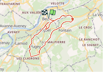
Trail Walking of 16.8 km to be discovered at Bourgogne-Franche-Comté, Doubs, Beure. This trail is proposed by eltonnermou.
Description
parking arbre de la libération, Beure
randonnée nécessitant l'utilisation des bâtons (au moins sur certaines parties).
Pour commencer, une fois franchit le chemin de l'ancienne voie romaine (ou celtique), vous allez longer le ruisseau "La Pisseur", suivez le balisage tâches/ronds rouges ; encore un espace un tant soit peu "sauvage"
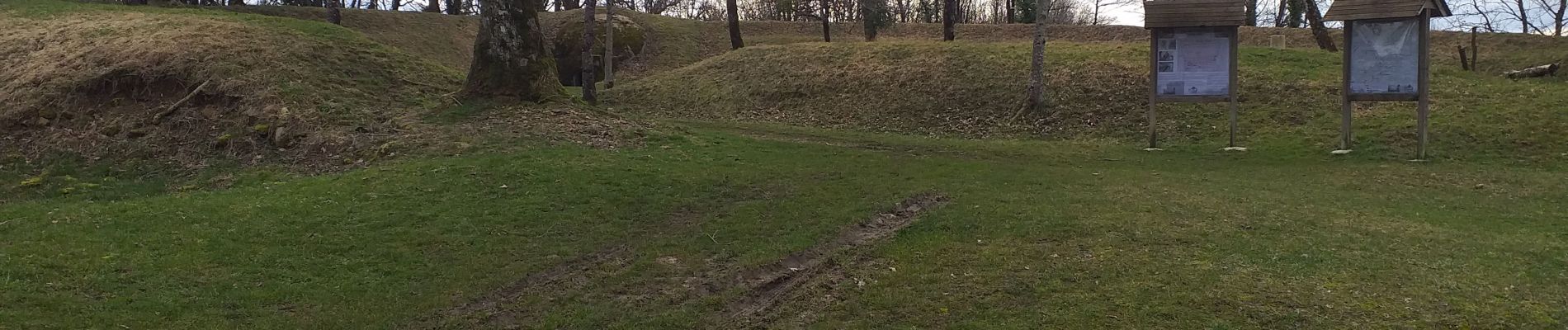
L'aller et retour avant le fort (ou forteresse) d'Arguel est d'un cheminement très difficile, du fait de blocs rocheux, de passage en à pic, donc nécessitant une capacité d'équilibre et de gestion du vertige. Le passage en tunnel naturel débouche sur un vertical d'environ 2 m. De ce fait cet A/R n'est pas obligatoire, cependant les nombreux points de vue sont la récompense de l'effort.
Cette randonnée est fortement agréable en milieux très variés, avec de nombreux points de vue sur toute sa longueur. Vous pourrez observer les bornes que vous verrez sur le parcours et le sillon sur le dessus qui indique le sens des limites des domaines concernés.
le passage après avoir longé à main droite la 4 voies des mercureaux est toujours très obstrué par des arbres déracinés. La variante est de poursuivre la route goudronnée, qui passe sous la 4 voies, pendant environ 1 km et de prendre à main gauche la petite route en direction du mercureau (ruisseau) et de repasser à nouveau sous la 4 voies et ainsi rejoindre la trace. Cela allonge la rando d'environ 1,5 km mais vous évite une montée assez rude et surtout un cheminement pendant 600m dans l'enchevêtrement d'arbres.
Et comme d'habitude laissez-vous surprendre par la nature, moi j'ai débusqué nombre d'oiseau : perdrix, geai, engoulevent ...
Positioning
Comments
Trails nearby
![Trail Walking Beure -](https://media.geolcdn.com/t/375/260/1d465e36-f50c-4143-b089-4392e69daccf.jpg&format=jpg&maxdim=2)
![Walking Walking](https://static1.geolcdn.com/sitytour/trail-icons/101.png)
Walking
![](/images/other/stat-length.png)
![](https://static1.geolcdn.com/siteimages/upload/files/16400158638029165_repeat_loop_refresh_sync_direction_icon.png)
![Trail Walking Beure - Beure, fort Planoise, Valmy, Roche trouée, vieille église. - Photo](https://media.geolcdn.com/t/375/260/f17b22e5-5227-4f08-8b37-03856be840af.jpg&format=jpg&maxdim=2)
![Walking Walking](https://static1.geolcdn.com/sitytour/trail-icons/101.png)
Walking
![](/images/other/stat-length.png)
![](https://static1.geolcdn.com/siteimages/upload/files/16400158638029165_repeat_loop_refresh_sync_direction_icon.png)
![Trail Walking Besançon - Colline de Besançon 29-08-2020 - Photo](https://media.geolcdn.com/t/375/260/1e155548-d400-46d3-8b28-207c9933a379.jpg&format=jpg&maxdim=2)
![Walking Walking](https://static1.geolcdn.com/sitytour/trail-icons/101.png)
Walking
![](/images/other/stat-length.png)
![](https://static1.geolcdn.com/siteimages/upload/files/16400158638029165_repeat_loop_refresh_sync_direction_icon.png)
![Trail Walking Fontain - fontain - fort de Fontain - forêt de Fontain - Photo](https://media.geolcdn.com/t/375/260/dda8671d-de1b-4872-afba-e5376a2d57f0.jpg&format=jpg&maxdim=2)
![Walking Walking](https://static1.geolcdn.com/sitytour/trail-icons/101.png)
Walking
![](/images/other/stat-length.png)
![](https://static1.geolcdn.com/siteimages/upload/files/16400158638029165_repeat_loop_refresh_sync_direction_icon.png)
![Trail On foot Busy - Sentier de la Pierre de Vorges - Photo](https://media.geolcdn.com/t/375/260/6f249824-322a-4d94-8931-19d5b1d90e88.jpeg&format=jpg&maxdim=2)
![On foot On foot](https://static1.geolcdn.com/sitytour/trail-icons/100.png)
On foot
![](/images/other/stat-length.png)
![](https://static1.geolcdn.com/siteimages/upload/files/16400158638029165_repeat_loop_refresh_sync_direction_icon.png)
![Trail On foot Fontain - Grande Boucle de Fontain - Photo](https://media.geolcdn.com/t/375/260/f1d37a4d-b9db-4571-aaef-737a004f40e0.jpeg&format=jpg&maxdim=2)
![On foot On foot](https://static1.geolcdn.com/sitytour/trail-icons/100.png)
On foot
![](/images/other/stat-length.png)
![](https://static1.geolcdn.com/siteimages/upload/files/16400158638029165_repeat_loop_refresh_sync_direction_icon.png)
![Trail On foot Morre - Sentier des Buis - Photo](https://media.geolcdn.com/t/375/260/00c23f5f-41e9-4001-afe9-fc138b72cbaf.jpeg&format=jpg&maxdim=2)
![On foot On foot](https://static1.geolcdn.com/sitytour/trail-icons/100.png)
On foot
![](/images/other/stat-length.png)
![](https://static1.geolcdn.com/siteimages/upload/files/16400158638029165_repeat_loop_refresh_sync_direction_icon.png)
![Trail On foot Fontain - Sentier des Grands Prés - Photo](https://media.geolcdn.com/t/375/260/b5a7d0a4-551b-456d-ac6c-7ab118f9fe97.jpeg&format=jpg&maxdim=2)
![On foot On foot](https://static1.geolcdn.com/sitytour/trail-icons/100.png)
On foot
![](/images/other/stat-length.png)
![](https://static1.geolcdn.com/siteimages/upload/files/16400158638029165_repeat_loop_refresh_sync_direction_icon.png)
![Trail On foot Besançon - Circuit de Planoise - Photo](https://media.geolcdn.com/t/375/260/8ca51ab7-77ad-4be9-b376-83a7b1e031a5.jpeg&format=jpg&maxdim=2)
![On foot On foot](https://static1.geolcdn.com/sitytour/trail-icons/100.png)
On foot
![](/images/other/stat-length.png)
![](https://static1.geolcdn.com/siteimages/upload/files/16400158638029165_repeat_loop_refresh_sync_direction_icon.png)