![](/images/other/stat-length.png)
![Trail Walking Leucate - Du plateau à l'étang de Leucate - Photo](https://media.geolcdn.com/t/1900/400/ext.pjpeg?maxdim=2&url=https%3A%2F%2Fstatic1.geolcdn.com%2Fsiteimages%2Fupload%2Ffiles%2F1553511878bg_sport_marche.png)
Du plateau à l'étang de Leucate
SoleilMoussanais
User
![Length](/images/other/stat-length.png)
Length
13.8 km
![Max alt](https://static1.geolcdn.com/siteimages/upload/files/1508320355ic_sort_altitude_max_24dp.png)
Max alt
59 m
![Uphill gradient](https://static1.geolcdn.com/siteimages/upload/files/1508320355ic_sort_den_pos_24dp.png)
Uphill gradient
173 m
![Km-Effort](/images/other/stat-length.png)
Km-Effort
16.1 km
![Min alt](https://static1.geolcdn.com/siteimages/upload/files/1508320355ic_sort_altitude_min_24dp.png)
Min alt
-3 m
![Downhill gradient](https://static1.geolcdn.com/siteimages/upload/files/1508320355ic_sort_den_neg_24dp.png)
Downhill gradient
173 m
![Boucle](https://static1.geolcdn.com/siteimages/upload/files/16400158638029165_repeat_loop_refresh_sync_direction_icon.png)
Boucle
Yes
Creation date :
2024-02-14 09:12:54.332
Updated on :
2024-02-14 09:16:18.968
![Walking](https://static1.geolcdn.com/sitytour/trail-icons/101.png)
4h00
Difficulty : Medium
![Scan this QR Code to open this trail in the SityTrail application](https://capi.geolives.com/qq0zvz2zws4bq2lad0pu/sitytour/trails/3949427/qr.png?size=200)
FREE GPS app for hiking
About
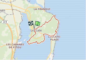
Trail Walking of 13.8 km to be discovered at Occitania, Aude, Leucate. This trail is proposed by SoleilMoussanais.
Description
Itinéraire relativement long mais sans difficultés majeures. Avec le sentier des bergers , les falaises calcaires puis les bords de l'étang.
Positioning
Country:
France
Region :
Occitania
Department/Province :
Aude
Municipality :
Leucate
Location:
Unknown
Start:(Dec)
Start:(UTM)
501993 ; 4750986 (31T) N.
Comments
Trails nearby
![Trail Walking Leucate - mon sentier des pêcheurs - Photo](https://media.geolcdn.com/t/375/260/d041d0df-07da-4421-a9ea-d982392d3e0c.jpg&format=jpg&maxdim=2)
![Walking Walking](https://static1.geolcdn.com/sitytour/trail-icons/101.png)
mon sentier des pêcheurs
Walking
Very easy
(1)
Leucate,
Occitania,
Aude,
France
![](/images/other/stat-length.png)
5.6 km | 6.5 km-effort
2h 7min
![](https://static1.geolcdn.com/siteimages/upload/files/16400158638029165_repeat_loop_refresh_sync_direction_icon.png)
Yes
![Trail Walking Leucate - Leucate village - Photo](https://media.geolcdn.com/t/375/260/ext.jpg?maxdim=2&url=https%3A%2F%2Fservices.sitytrail.com%2FGeolivesWS%2FDownloadMedia.ashx%3FTrailID%3D179085%26Media%3Df1524f36-0682-4bf6-975a-882cd23421f5.JPG)
![Walking Walking](https://static1.geolcdn.com/sitytour/trail-icons/101.png)
Leucate village
Walking
Medium
(2)
Leucate,
Occitania,
Aude,
France
![](/images/other/stat-length.png)
7 km | 8.2 km-effort
1h 46min
![](https://static1.geolcdn.com/siteimages/upload/files/16400158638029165_repeat_loop_refresh_sync_direction_icon.png)
Yes
![Trail Mountain bike Leucate - Leucate sur un plateau ! - Photo](https://media.geolcdn.com/t/375/260/ext.jpg?maxdim=2&url=https%3A%2F%2Fservices.sitytrail.com%2FGeolivesWS%2FDownloadMedia.ashx%3FTrailID%3D100672%26Media%3D196_3.jpg)
![Mountain bike Mountain bike](https://static1.geolcdn.com/sitytour/trail-icons/202.png)
Leucate sur un plateau !
Mountain bike
Easy
(1)
Leucate,
Occitania,
Aude,
France
![](/images/other/stat-length.png)
10.8 km | 12.4 km-effort
45min
![](https://static1.geolcdn.com/siteimages/upload/files/16400158638029165_repeat_loop_refresh_sync_direction_icon.png)
No
![Trail Mountain bike Leucate - VTT Leucate La Palme - Photo](https://media.geolcdn.com/t/375/260/f6afc4d0-f8dc-4d8d-bdc2-3236cac7bfec.jpg&format=jpg&maxdim=2)
![Mountain bike Mountain bike](https://static1.geolcdn.com/sitytour/trail-icons/202.png)
VTT Leucate La Palme
Mountain bike
Easy
(1)
Leucate,
Occitania,
Aude,
France
![](/images/other/stat-length.png)
29 km | 32 km-effort
2h 10min
![](https://static1.geolcdn.com/siteimages/upload/files/16400158638029165_repeat_loop_refresh_sync_direction_icon.png)
Yes
![Trail Walking Leucate - plateau leucate - sud est - Photo](https://media.geolcdn.com/t/375/260/fc551c80-a7a1-459f-83d9-ef8bc94cafd9.jpg&format=jpg&maxdim=2)
![Walking Walking](https://static1.geolcdn.com/sitytour/trail-icons/101.png)
plateau leucate - sud est
Walking
Easy
Leucate,
Occitania,
Aude,
France
![](/images/other/stat-length.png)
11.1 km | 13 km-effort
3h 23min
![](https://static1.geolcdn.com/siteimages/upload/files/16400158638029165_repeat_loop_refresh_sync_direction_icon.png)
Yes
![Trail Walking Leucate - leucate - cap des frères (sentier des bergers) -la franqui (sentier des guetteurs) - leucate (se tier des vignerons) - Photo](https://media.geolcdn.com/t/375/260/5389bc4c-6ebc-475a-8eed-23be4124a740.jpg&format=jpg&maxdim=2)
![Walking Walking](https://static1.geolcdn.com/sitytour/trail-icons/101.png)
leucate - cap des frères (sentier des bergers) -la franqui (sentier des guett...
Walking
Difficult
Leucate,
Occitania,
Aude,
France
![](/images/other/stat-length.png)
10.6 km | 12.5 km-effort
4h 22min
![](https://static1.geolcdn.com/siteimages/upload/files/16400158638029165_repeat_loop_refresh_sync_direction_icon.png)
Yes
![Trail Walking Leucate - 2023-02-03_17h08m34_SityTrail - 3539502 - leucate-plateau-chemin-vigneronx-franquix-le-fort-xcao-frerex-semaphore - Photo](https://media.geolcdn.com/t/375/260/ext.jpg?maxdim=2&url=https%3A%2F%2Fstatic1.geolcdn.com%2Fsiteimages%2Fupload%2Ffiles%2F1553511878bg_sport_marche.png)
![Walking Walking](https://static1.geolcdn.com/sitytour/trail-icons/101.png)
2023-02-03_17h08m34_SityTrail - 3539502 - leucate-plateau-chemin-vigneronx-fr...
Walking
Easy
(1)
Leucate,
Occitania,
Aude,
France
![](/images/other/stat-length.png)
10.1 km | 12.3 km-effort
2h 47min
![](https://static1.geolcdn.com/siteimages/upload/files/16400158638029165_repeat_loop_refresh_sync_direction_icon.png)
Yes
![Trail Walking Leucate - Leucate château falaise - Photo](https://media.geolcdn.com/t/375/260/3cce4778-81ed-4254-af5e-b0b5f1ccbabf.jpg&format=jpg&maxdim=2)
![Walking Walking](https://static1.geolcdn.com/sitytour/trail-icons/101.png)
Leucate château falaise
Walking
Very easy
Leucate,
Occitania,
Aude,
France
![](/images/other/stat-length.png)
15.2 km | 17.8 km-effort
3h 31min
![](https://static1.geolcdn.com/siteimages/upload/files/16400158638029165_repeat_loop_refresh_sync_direction_icon.png)
Yes
![Trail Walking Leucate - Plateau etang Leucate - Photo](https://media.geolcdn.com/t/375/260/ext.jpg?maxdim=2&url=https%3A%2F%2Fstatic1.geolcdn.com%2Fsiteimages%2Fupload%2Ffiles%2F1553511878bg_sport_marche.png)
![Walking Walking](https://static1.geolcdn.com/sitytour/trail-icons/101.png)
Plateau etang Leucate
Walking
Easy
(1)
Leucate,
Occitania,
Aude,
France
![](/images/other/stat-length.png)
13.8 km | 16.1 km-effort
3h 33min
![](https://static1.geolcdn.com/siteimages/upload/files/16400158638029165_repeat_loop_refresh_sync_direction_icon.png)
Yes