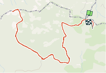
Trail Walking Saint-Raphaël - balisage - Photo
© OpenStreetMap contributors
Length
Length
10.3 km
Max alt
Max alt
363 m
Uphill gradient
Uphill gradient
208 m
Km-Effort
Km-Effort  
13.2 km
Min alt
Min alt
247 m
Downhill gradient
Downhill gradient
219 m
Boucle
Boucle
No
Creation date :
2024-02-13 07:59:48.845
Updated on :
2024-02-13 19:36:19.716

(0 Reviews)

Walking
Walking
2h38
Difficulty : Medium

Scan this QR Code to open this trail in the SityTrail application

FREE GPS app for hiking

Logo SityTrail SityTrail

IGN / Geographical institutes

Download SityTrail from the App Store Download SityTrail from Google Play

Logo SityTrail SityTrail World

The world is yours!

Download SityTrail from the App Store Download SityTrail from Google Play Download SityTrail on Huawei AppGallery

About

Trail Walking of 10.3 km to be discovered at Provence-Alpes-Côte d'Azur, Var, Saint-Raphaël. This trail is proposed by jack.cavelier@orange.fr.

Elevation profile

Photos

Positioning

Country:
France
Region :
Provence-Alpes-Côte d'Azur
Department/Province :
Var
Municipality :
Saint-Raphaël
Location:
Unknown
Start:(UTM)
328900 ; 4818785 (32T) N.

Trails nearby

Trail Walking Saint-Raphaël - Les lacs par les rochers du Caneiret - Photo
Walking
ETMU5496

Walking

Medium
(1)
Saint-Raphaël, Provence-Alpes-Côte d'Azur, Var, France
20 km | 29 km-effort
5h 7min
Yes
Trail Walking Saint-Raphaël - Le tour du Pic du Cap Roux - St Raphaël (Agay) - Photo
Walking
tracegps

Walking

Medium
(2)
Saint-Raphaël, Provence-Alpes-Côte d'Azur, Var, France
7.2 km | 12.8 km-effort
2h 0min
Yes
Trail Walking Saint-Raphaël - Pic du Cap Roux - Photo
Walking
Kilroy06

Walking

Very easy
(4)
Saint-Raphaël, Provence-Alpes-Côte d'Azur, Var, France
4.1 km | 7.8 km-effort
1h 17min
Yes
Trail Walking Mandelieu-la-Napoule - Mont Saint Martin - Photo
Walking
Kilroy06

Walking

Easy
(1)
Mandelieu-la-Napoule, Provence-Alpes-Côte d'Azur, Maritime Alps, France
9 km | 14.2 km-effort
3h 0min
Yes
Trail Walking Saint-Raphaël - SityTrail - ND - Aiguille  - Photo
Walking
GUIDE
jouans

Walking

Very difficult
(1)
Saint-Raphaël, Provence-Alpes-Côte d'Azur, Var, France
18.1 km | 29 km-effort
6h 40min
Yes
Trail Walking Saint-Raphaël - Tour du Pic de l'Ours - Le Trayas - Photo
Walking
tracegps

Walking

Medium
(1)
Saint-Raphaël, Provence-Alpes-Côte d'Azur, Var, France
9.5 km | 16 km-effort
3h 0min
Yes
Trail On foot Théoule-sur-Mer - Tracé Rocher des Monges par col de Théoule - Photo
On foot
Sylvie Cagnes

On foot

Very easy
(1)
Théoule-sur-Mer, Provence-Alpes-Côte d'Azur, Maritime Alps, France
7.2 km | 11.2 km-effort
Unknown
Yes
Trail Walking Théoule-sur-Mer - Théoule-sur-mer - Grosses Grues - Photo
Walking
GUIDE
Orcal37

Walking

Medium
Théoule-sur-Mer, Provence-Alpes-Côte d'Azur, Maritime Alps, France
14.7 km | 23 km-effort
4h 30min
Yes
Trail Walking Saint-Raphaël - pic de l'ours pic d' aurelle - Photo
Walking
puchol

Walking

Medium
(2)
Saint-Raphaël, Provence-Alpes-Côte d'Azur, Var, France
10.8 km | 17.7 km-effort
4h 3min
Yes


Close
My subscriptions