Trail Mountain bike Saint-Cirq-Lapopie - Rando VTT St-Cirq-Lapopie - Igue de Crégols - Photo

Rando VTT St-Cirq-Lapopie - Igue de Crégols

 simon32
simon32

User

© OpenStreetMap contributors
Length
Length
41 km
Max alt
Max alt
376 m
Uphill gradient
Uphill gradient
1202 m
Km-Effort
Km-Effort  
57 km
Min alt
Min alt
129 m
Downhill gradient
Downhill gradient
1200 m
Boucle
Boucle
Yes
Creation date :
2015-03-11 00:00:00.0
Updated on :
2015-03-11 00:00:00.0

(0 Reviews)

Mountain bike
Mountain bike
3h37
Difficulty : Difficult

Scan this QR Code to open this trail in the SityTrail application

FREE GPS app for hiking

Logo SityTrail SityTrail

IGN / Geographical institutes

Download SityTrail from the App Store Download SityTrail from Google Play

Logo SityTrail SityTrail World

The world is yours!

Download SityTrail from the App Store Download SityTrail from Google Play Download SityTrail on Huawei AppGallery

About

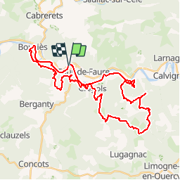
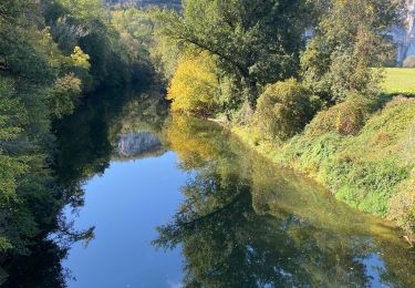
Trail Mountain bike of 41 km to be discovered at Occitania, Lot, Saint-Cirq-Lapopie. This trail is proposed by simon32.

Description

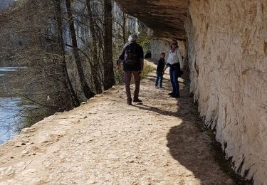
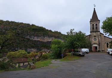
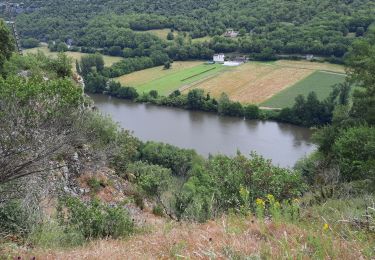
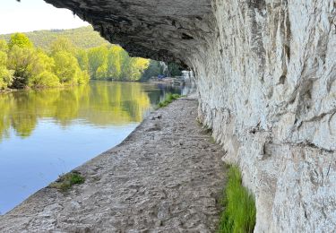
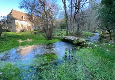
Un beau circuit avec alternance de chemins, sentiers et beaux points de vue.Le circuit débute en longeant le Lot au pied des falaises, pour s'engager plus loin sur l’ancien chemin de halage, taillé dans la falaise, superbe !Arrivé à Bouziès, une portion goudronnée permet de prendre de la hauteur, puis chemins et sentiers, à travers buis, ramènent facilement sur les hauteurs de St-Cirq. Suivent un rude chemin montant...puis une petite route... et enfin, récompense, un beau single à profil descendant, il rejoint le GR qui plonge ensuite jusqu’au point de vue sur le cirque de Vènes. Un peu plus loin, s'engage une belle descente dans les buis. Ça devient de plus en plus technique... la fin devant se faire à côté du vélo. On atteint le hameau de Crégols, un chemin montant rejoint le gouffre, "l'Igue" en jargon local. Après un passage sur un chemin empierré où les TS seront à la fête... puis quelques cheminements en fond de combe, un beau sentier s'amorce à Roquecave, peu pentu mais très roulant, régal ! Passé St Clair, un single rapide et rectiligne rejoint une piste, d'où les plus curieux pourront faire un aller-retour vers la résurgence de "Trou Madame". La piste s'élève ensuite vers le "Mas de Labat", d'où l’on rejoindra en bord de falaise un trop court single joueur (ne pas laisser filer sur ce single la bifurcation à gauche qui s'engage sur une portion plus pentue). On retrouve la vallée à Cénevières. Arrivé à Crégols, on frôlera la trace de l'aller, il ne faudra pas rater le discret sentier qui s'engage à droite au niveau d'un parapet. Un peu de goudron ramènera ensuite à la plage... de St-Cirq.

Elevation profile

Positioning

Country:
France
Region :
Occitania
Department/Province :
Lot
Municipality :
Saint-Cirq-Lapopie
Location:
Unknown
Start:(UTM)
394893 ; 4924942 (31T) N.

Trails nearby

Trail Walking Saint-Cirq-Lapopie - Circuit sud de St Cirq Lapopie - Photo
Walking
tracegps

Walking

Difficult
(4)
Saint-Cirq-Lapopie, Occitania, Lot, France
17.7 km | 24 km-effort
3h 30min
Yes
Trail Walking Bouziès - St Cirq Lapopie - Photo
Walking
neleda

Walking

Very easy
(1)
Bouziès, Occitania, Lot, France
8.3 km | 12.4 km-effort
2h 33min
No
Trail Walking Cabrerets - Cabrenets Bouziès St Cirq Bouziés - Photo
Walking
GUIDE
nadinebondoux

Walking

Medium
Cabrerets, Occitania, Lot, France
16.2 km | 24 km-effort
5h 21min
No
Trail Walking Bouziès - Étape 4 Bouziès  Les Mazuts  - Photo
Walking
GUIDE
nadinebondoux

Walking

Difficult
Bouziès, Occitania, Lot, France
21 km | 30 km-effort
6h 29min
No
Trail Walking Cabrerets - Lot CABRERET BEARD - Photo
Walking
JEAN06910

Walking

Medium
Cabrerets, Occitania, Lot, France
24 km | 34 km-effort
4h 44min
No
Trail sport Saint-Cirq-Lapopie - 20240422 St Cirq - Vers - Photo
sport
ThonyM

sport

Very easy
Saint-Cirq-Lapopie, Occitania, Lot, France
22 km | 31 km-effort
Unknown
No
Trail sport Cabrerets - 20240421 Cabrerets - St Cirq - Photo
sport
ThonyM

sport

Very easy
Cabrerets, Occitania, Lot, France
11.6 km | 17.4 km-effort
Unknown
No
Trail Walking Cabrerets - Cabrerets Liauzu  - Photo
Walking
GUIDE
antignacs

Walking

Easy
Cabrerets, Occitania, Lot, France
12.3 km | 17.5 km-effort
3h 3min
Yes
Trail Walking Bouziès - Bouzies St Cirq Conduche  - Photo
Walking
GUIDE
antignacs

Walking

Very easy
Bouziès, Occitania, Lot, France
15.3 km | 21 km-effort
4h 11min
Yes


Close
My subscriptions