


Thailand Laos

kenleggat
User

Length
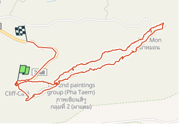
4.8 km

Max alt
241 m

Uphill gradient
102 m
Km-Effort
6.2 km

Min alt
169 m

Downhill gradient
106 m
Boucle
No
Creation date :
2024-02-12 02:05:49.92
Updated on :
2024-02-12 05:12:43.687
3h05
Difficulty : Very easy

FREE GPS app for hiking
 SityTrail
IGN / Geographical institutes
SityTrail World
The world is yours!
About
Trail Walking of 4.8 km to be discovered at Ubon Ratchathani Province. This trail is proposed by kenleggat.
Positioning
Country:
Thailand
Region :
Ubon Ratchathani Province
Department/Province :
Unknown
Municipality :
Unknown
Location:
Unknown
Start:(Dec)
Start:(UTM)
554479 ; 1702521 (48P) N.
Comments
Trails nearby