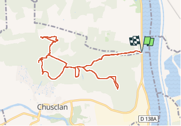
Trail Walking Saint-Étienne-des-Sorts - La Dent De Marcoule. 13 kms  - Photo

La Dent De Marcoule. 13 kms

© OpenStreetMap contributors
Length
Length
13 km
Max alt
Max alt
215 m
Uphill gradient
Uphill gradient
316 m
Km-Effort
Km-Effort  
17.2 km
Min alt
Min alt
35 m
Downhill gradient
Downhill gradient
316 m
Boucle
Boucle
Yes
Creation date :
2024-02-11 09:02:28.373
Updated on :
2024-02-11 14:34:39.596

(0 Reviews)

Walking
Walking
3h24
Difficulty : Difficult

Scan this QR Code to open this trail in the SityTrail application

FREE GPS app for hiking

Logo SityTrail SityTrail

IGN / Geographical institutes

Download SityTrail from the App Store Download SityTrail from Google Play

Logo SityTrail SityTrail World

The world is yours!

Download SityTrail from the App Store Download SityTrail from Google Play Download SityTrail on Huawei AppGallery

About

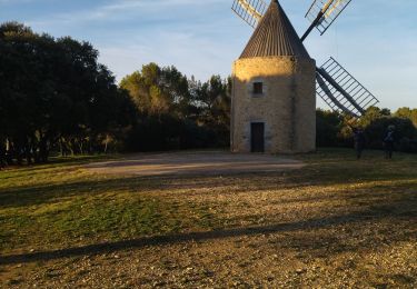
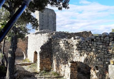
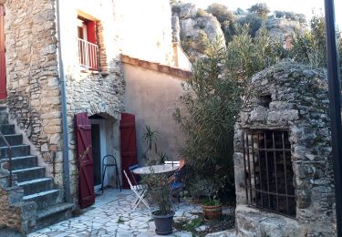
Trail Walking of 13 km to be discovered at Occitania, Gard, Saint-Étienne-des-Sorts. This trail is proposed by Christophe Toubas.

Description

Très belle randonnée variée en passant à côté du château du Joncquier et celui du Gicon. Beaucoup de dénivelé.

Elevation profile

Positioning

Country:
France
Region :
Occitania
Department/Province :
Gard
Municipality :
Saint-Étienne-des-Sorts
Location:
Unknown
Start:(UTM)
637049 ; 4891360 (31T) N.

Trails nearby

Trail Walking Vénéjan - 30 venejean - Photo
Walking
GUIDE
randodyssée

Walking

Medium
Vénéjan, Occitania, Gard, France
23 km | 29 km-effort
7h 11min
Yes
Trail Walking Piolenc - Piolenc - Valbonnette - La Barjavelle - Photo
Walking
tracegps

Walking

Medium
(1)
Piolenc, Provence-Alpes-Côte d'Azur, Vaucluse, France
9.1 km | 11.6 km-effort
2h 40min
Yes
Trail Walking Piolenc - 84 st montant zel - Photo
Walking
GUIDE
randodyssée

Walking

Easy
Piolenc, Provence-Alpes-Côte d'Azur, Vaucluse, France
14.6 km | 19.4 km-effort
6h 1min
Yes
Trail Walking Chusclan - CHUSCLAN - Fontaine du Renard - GICON - VENEJAN - Photo
Walking
GOIOLIRIBES

Walking

Very difficult
Chusclan, Occitania, Gard, France
15.3 km | 19.7 km-effort
6h 4min
Yes
Trail Walking Vénéjan - Venejean - Photo
Walking
GUIDE
Roger Philippe Wallez

Walking

Very difficult
Vénéjan, Occitania, Gard, France
17.5 km | 23 km-effort
6h 26min
Yes
Trail Walking Piolenc - Piolenc-Les Grottes-Chapelle St Baudile-Ancienne Forteresse de Mornas14km.. - Photo
Walking
chancha

Walking

Difficult
Piolenc, Provence-Alpes-Côte d'Azur, Vaucluse, France
14.2 km | 18.5 km-effort
4h 12min
Yes
Trail Walking Vénéjan - Vénéjean Chateau de Gicon - Photo
Walking
GUIDE
nadinebondoux

Walking

Medium
Vénéjan, Occitania, Gard, France
16.5 km | 21 km-effort
4h 27min
Yes
Trail Walking Chusclan - Venejan_041121 - Photo
Walking
fario

Walking

Very difficult
Chusclan, Occitania, Gard, France
14.8 km | 19 km-effort
4h 19min
Yes
Trail Walking Mornas - Forteresse de Mornas - Photo
Walking
GUIDE
nadinebondoux

Walking

Medium
Mornas, Provence-Alpes-Côte d'Azur, Vaucluse, France
22 km | 28 km-effort
6h 8min
Yes


Close
My subscriptions