Trail Walking Mauves-sur-Huisne - [Itinéraire] Mortous : autour des méandres de l'Huisne - Photo

[Itinéraire] Mortous : autour des méandres de l'Huisne

 ODDAD78
ODDAD78

User

© OpenStreetMap contributors
Length
Length
3 km
Max alt
Max alt
155 m
Uphill gradient
Uphill gradient
28 m
Km-Effort
Km-Effort  
3.3 km
Min alt
Min alt
137 m
Downhill gradient
Downhill gradient
28 m
Boucle
Boucle
Yes
Creation date :
2024-02-08 18:42:28.925
Updated on :
2024-02-08 18:48:18.113

(0 Reviews)

Walking
Walking
45m
Difficulty : Easy

Scan this QR Code to open this trail in the SityTrail application

FREE GPS app for hiking

Logo SityTrail SityTrail

IGN / Geographical institutes

Download SityTrail from the App Store Download SityTrail from Google Play

Logo SityTrail SityTrail World

The world is yours!

Download SityTrail from the App Store Download SityTrail from Google Play Download SityTrail on Huawei AppGallery

About

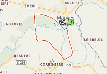
Trail Walking of 3 km to be discovered at Normandy, Orne, Mauves-sur-Huisne. This trail is proposed by ODDAD78.

Description

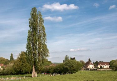
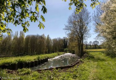
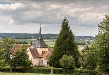
Agréable parcours en campagne qui forme une boucle autour de l'Huisne. Découverte de la faune et de la flore d'une zone humide. Panorama unique sur l'arrière du bourg de Mauves-sur-Huisne et de l'église Saint-Pierre.
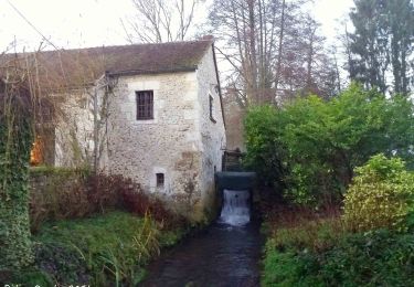
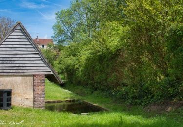
En partant d'un ancien lavoir restauré vous suivrez les méandres de l'Huisne. Vous vous trouverez au coeur d'une zone humide naturelle pour ensuite emprunter le remarquable chemin creux de Mortous. Après avoir traversé le pont Catinat construit en 1610 vous rejoindrez le village - rue de Mauves et ses alignements de maisons et d'arbres.

Pas à pas (Rando-Perche)

Départ : Mauves-sur-Huisne Arrivée : Mauves-sur-Huisne Balisage : PR
Communes : 1. Mauves-sur-Huisne
Départ place de la mairie.
1. Prendre le chemin de l'Abreuvoir puis rue de la Huchette en contrebas.
2. Passer devant le lavoir communal et emprunter le chemin en herbe à droite, le long d'un mur.
Poursuivre sur 900m.
3. A gauche, prendre la direction de Mortous (panneau).
4. Passer au dessus de l'Huisne et continuer tout droit sur le chemin creux jusqu'à Mortous.
5. Prendre le chemin empierré sur gauche et continuer jusqu'au lieu dit "Pont".
6. Prendre à gauche en empruntant la D9. Traverser l'Huisne sur le pont Catinat pour remonter
jusqu'en haut du bourg sur la rue de Mauves, jusqu'à retrouver la place de la mairie.

Elevation profile

Points of interest

Point of interest Mauves-sur-Huisne - Histoire: Synthèse communale - Photo
ODDAD78
Point of interest Mauves-sur-Huisne - Architecture: Le pont Catinat - Photo
ODDAD78

Positioning

Country:
France
Region :
Normandy
Department/Province :
Orne
Municipality :
Mauves-sur-Huisne
Location:
Unknown
Start:(UTM)
324061 ; 5368802 (31U) N.

Trails nearby

Trail Walking La Chapelle-Montligeon - [Itinéraire] Le Mont Ligeon - Photo
Walking
ODDAD78

Walking

Medium
La Chapelle-Montligeon, Normandy, Orne, France
5.1 km | 6.6 km-effort
1h 30min
Yes
Trail Walking La Chapelle-Montligeon - La Chapelle-Montligeon - Longny-au-Perche via Bizou 16 km - Photo
Walking

Walking

Very difficult
La Chapelle-Montligeon, Normandy, Orne, France
15.9 km | 20 km-effort
4h 22min
No
Trail Walking La Chapelle-Montligeon - La Chapelle-Montligeon - Moutiers-au-Perche via Bizou 20 km - Photo
Walking

Walking

Very difficult
La Chapelle-Montligeon, Normandy, Orne, France
20 km | 26 km-effort
5h 33min
No
Trail Walking La Chapelle-Montligeon - La Chapelle-Montligeon - Le Mage via Bizou 18 km - Photo
Walking

Walking

Very difficult
La Chapelle-Montligeon, Normandy, Orne, France
17.9 km | 23 km-effort
4h 53min
No
Trail Walking Mauves-sur-Huisne - Mauves-sur-Huisne - Nocé-Courboyer 14 km - Photo
Walking

Walking

Medium
Mauves-sur-Huisne, Normandy, Orne, France
13.6 km | 17.2 km-effort
3h 10min
No
Trail Walking La Chapelle-Montligeon - La Chapelle-Montligeon - Mauves-sur-Huisne 7,8 km - Photo
Walking

Walking

Medium
La Chapelle-Montligeon, Normandy, Orne, France
7.8 km | 9.2 km-effort
2h 2min
No
Trail Walking Perche en Nocé - Le Vieux bourg  5km - Photo
Walking
ODDAD78

Walking

Very easy
Perche en Nocé, Normandy, Orne, France
4.8 km | 6.1 km-effort
1h 19min
Yes
Trail Walking Mauves-sur-Huisne - Mauves-sur-Huisne - Mortagne-au-Perche 11 km - Photo
Walking

Walking

Medium
Mauves-sur-Huisne, Normandy, Orne, France
10.7 km | 12.4 km-effort
2h 56min
No
Trail Walking La Chapelle-Montligeon - La Chapelle-Montligeon - Tourouvre 19 km - Photo
Walking

Walking

Easy
La Chapelle-Montligeon, Normandy, Orne, France
19 km | 24 km-effort
4h 28min
No


Close
My subscriptions