![](/images/other/stat-length.png)
![Trail Walking Marolles-les-Buis - [Itinéraire] Le hameau de la Cloche - Photo](https://media.geolcdn.com/t/1900/400/ext.pjpeg?maxdim=2&url=https%3A%2F%2Fstatic1.geolcdn.com%2Fsiteimages%2Fupload%2Ffiles%2F1553511878bg_sport_marche.png)
[Itinéraire] Le hameau de la Cloche
ODDAD78
User
![Length](/images/other/stat-length.png)
![Max alt](https://static1.geolcdn.com/siteimages/upload/files/1508320355ic_sort_altitude_max_24dp.png)
![Uphill gradient](https://static1.geolcdn.com/siteimages/upload/files/1508320355ic_sort_den_pos_24dp.png)
![Km-Effort](/images/other/stat-length.png)
![Min alt](https://static1.geolcdn.com/siteimages/upload/files/1508320355ic_sort_altitude_min_24dp.png)
![Downhill gradient](https://static1.geolcdn.com/siteimages/upload/files/1508320355ic_sort_den_neg_24dp.png)
![Boucle](https://static1.geolcdn.com/siteimages/upload/files/16400158638029165_repeat_loop_refresh_sync_direction_icon.png)
![Walking](https://static1.geolcdn.com/sitytour/trail-icons/101.png)
2h22
Difficulty : Medium
![Scan this QR Code to open this trail in the SityTrail application](https://capi.geolives.com/qq0zvz2zws4bq2lad0pu/sitytour/trails/3942738/qr.png?size=200)
FREE GPS app for hiking
About
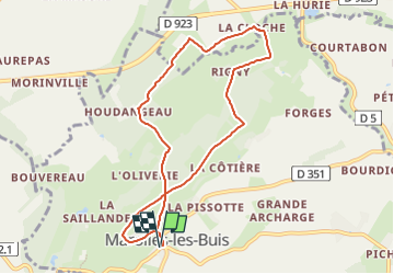
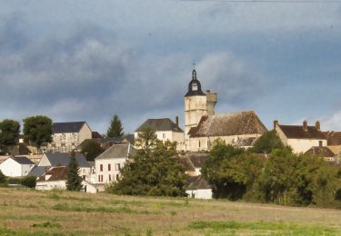
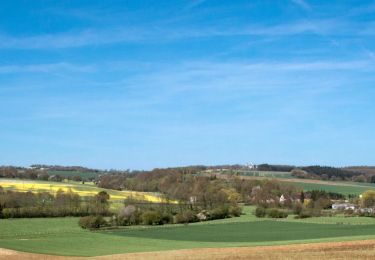
Trail Walking of 8.1 km to be discovered at Centre-Loire Valley, Eure-et-Loir, Marolles-les-Buis. This trail is proposed by ODDAD78.
Description
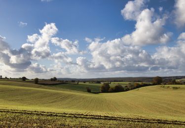
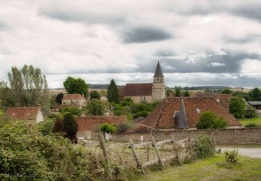
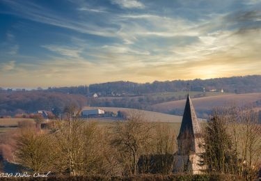
Une balade aux environ du Maquis de Plainville, haut lieu de la résistance percheronne, sur des chemins bordés de haies de buis, avec vue sur les méandres de la Cloche.
Ce circuit est labellisé par la Fédération Française de Randonnée. Il fait également partie d'une offre d'ecobalade proposée par l'association Eure-et-Loir Nature.
Cette randonnée, bordée de nombreuses pâtures, permet de découvrir la vallée verdoyante de La Cloche. La rivière de la Cloche prend sa source sur la commune voisine de Frétigny et se jette dans l’Huisne (rivière qui traverse Nogent-le- Rotrou). Ce circuit est également chargé d’histoire et de mémoire. En effet, dans un bosquet, face à la ferme du même nom, le maquis de Plainville, haut lieu de la Résistance, se dévoilera au randonneur.
Pas à Pas (Rando-Perche)
Départ : Marolles-les-Buis Arrivée : Marolles-les-Buis Balisage : PR
Communes : 1. Marolles-les-Buis 2. Saint-Victor-de-Buthon
1. Utiliser le petit chemin derrière l’église. Au bout, prendre la D 351 à gauche, puis monter tout droit.
2. A la fourche, monter à droite par la D351-2 et arriver sur la crête.
3. Poursuivre par la D351-2. Prendre la D103-11 à droite (passage devant le château de la
Vignardière), puis descendre à gauche par la petite route. Dans le virage, continuer par le chemin
et franchir la passerelle.
4. A l’orée du bois, prendre le chemin à droite, en lisière, et gagner les Barres (un centre équestre
situé gzuche). Au croisement en "T" descendre par le chemin de droite, qui vire ensuite à gauche.
5. Au carrefour, dans le hameau de la Cloche, tourner à droite et poursuivre par un chemin. Franchir
la passerelle, puis bifurquer à droite. Puis prendre à droite la D103-11.
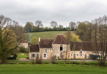
6. A la hauteur de la ferme de Rigny, monter par le chemin à gauche, d’abord en lisière puis en
sous-bois et atteindre une intersection. Prendre le chemin à droite. Il ramène à la D 351-2
(présence d'un calvaire), au repère n° 3 de l'aller : continuer par le chemin en face.
7. A la croisée (croix de chemin), descendre à gauche par le chemin caillouteux et retourner à la
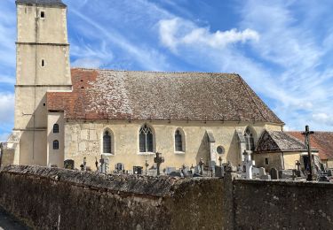
fourche des Boissetières. Au repère n°2, descendre à droite pour rejoindre l’église Saint-Vincent.
Positioning
Comments
Trails nearby
![Trail Walking Arcisses - Coudreceau, les panoramas du Perche Eurélien 9,4 km - Photo](https://media.geolcdn.com/t/375/260/93185f9c-ce34-4e92-883e-ab49829b2889.jpeg&format=jpg&maxdim=2)
![Walking Walking](https://static1.geolcdn.com/sitytour/trail-icons/101.png)
Walking
![](/images/other/stat-length.png)
![](https://static1.geolcdn.com/siteimages/upload/files/16400158638029165_repeat_loop_refresh_sync_direction_icon.png)
![Trail Walking Arcisses - Brunelles - Autour du Promontoire 10 km - Photo](https://media.geolcdn.com/t/375/260/d22874c5-839f-4011-a0f9-00e8c44e1208.jpeg&format=jpg&maxdim=2)
![Walking Walking](https://static1.geolcdn.com/sitytour/trail-icons/101.png)
Walking
![](/images/other/stat-length.png)
![](https://static1.geolcdn.com/siteimages/upload/files/16400158638029165_repeat_loop_refresh_sync_direction_icon.png)
![Trail Walking Arcisses - 2023-04-24_20h15m45_Ozée 9,1 km - Photo](https://media.geolcdn.com/t/375/260/ext.jpg?maxdim=2&url=https%3A%2F%2Fstatic1.geolcdn.com%2Fsiteimages%2Fupload%2Ffiles%2F1553511878bg_sport_marche.png)
![Walking Walking](https://static1.geolcdn.com/sitytour/trail-icons/101.png)
Walking
![](/images/other/stat-length.png)
![](https://static1.geolcdn.com/siteimages/upload/files/16400158638029165_repeat_loop_refresh_sync_direction_icon.png)
![Trail Walking Marolles-les-Buis - SityTrail - Le hameau de la Cloche 7,4 km - Photo](https://media.geolcdn.com/t/375/260/be06a1ec-da26-4982-bec0-14d197dfa4b5.jpg&format=jpg&maxdim=2)
![Walking Walking](https://static1.geolcdn.com/sitytour/trail-icons/101.png)
Walking
![](/images/other/stat-length.png)
![](https://static1.geolcdn.com/siteimages/upload/files/16400158638029165_repeat_loop_refresh_sync_direction_icon.png)
![Trail Walking Arcisses - Coudreceau - Saint-Victor-de-Buthon 11 km - Photo](https://media.geolcdn.com/t/375/260/0e7de4a4-08a4-4fcb-97dc-5370116ce0be.jpg&format=jpg&maxdim=2)
![Walking Walking](https://static1.geolcdn.com/sitytour/trail-icons/101.png)
Walking
![](/images/other/stat-length.png)
![](https://static1.geolcdn.com/siteimages/upload/files/16400158638029165_repeat_loop_refresh_sync_direction_icon.png)
![Trail Walking Arcisses - Coudreceau - Nogent-le-Rotrou 11 km - Photo](https://media.geolcdn.com/t/375/260/b9a44e85-5a21-4b01-b59f-00bbfdd7e9b5.jpg&format=jpg&maxdim=2)
![Walking Walking](https://static1.geolcdn.com/sitytour/trail-icons/101.png)
Walking
![](/images/other/stat-length.png)
![](https://static1.geolcdn.com/siteimages/upload/files/16400158638029165_repeat_loop_refresh_sync_direction_icon.png)
![Trail Walking Arcisses - Coudreceau - Thiron-Gardais 9,2 km - Photo](https://media.geolcdn.com/t/375/260/18fddcac-d0bd-464b-8f75-cea37d64eb13.jpg&format=jpg&maxdim=2)
![Walking Walking](https://static1.geolcdn.com/sitytour/trail-icons/101.png)
Walking
![](/images/other/stat-length.png)
![](https://static1.geolcdn.com/siteimages/upload/files/16400158638029165_repeat_loop_refresh_sync_direction_icon.png)
![Trail Walking Arcisses - Rando Brunelles - Photo](https://media.geolcdn.com/t/375/260/0effcb9d-a127-4b0b-8d0d-8ce8b41d610b.jpg&format=jpg&maxdim=2)
![Walking Walking](https://static1.geolcdn.com/sitytour/trail-icons/101.png)
Walking
![](/images/other/stat-length.png)
![](https://static1.geolcdn.com/siteimages/upload/files/16400158638029165_repeat_loop_refresh_sync_direction_icon.png)
![Trail Walking Marolles-les-Buis - 15-JAN-19 16:36:07 - Photo](https://media.geolcdn.com/t/375/260/786de18b-74a9-4fc3-9eb6-5a67c491a997.jpg&format=jpg&maxdim=2)
![Walking Walking](https://static1.geolcdn.com/sitytour/trail-icons/101.png)
Walking
![](/images/other/stat-length.png)
![](https://static1.geolcdn.com/siteimages/upload/files/16400158638029165_repeat_loop_refresh_sync_direction_icon.png)