


Tokachidake

gas
User
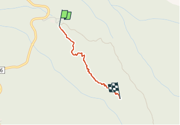

Length
1.9 km

Max alt
1309 m

Uphill gradient
270 m
Km-Effort
4.6 km

Min alt
1026 m

Downhill gradient
0 m
Boucle
No
Creation date :
2024-02-07 00:16:21.0
Updated on :
2024-02-07 04:48:31.706
1h17
Difficulty : Unknown

FREE GPS app for hiking
 SityTrail
IGN / Geographical institutes
SityTrail World
The world is yours!
About
Trail Trail of 1.9 km to be discovered at Hokkaido Prefecture, Sorachi County. This trail is proposed by gas.
Description
Monte
Positioning
Country:
Japan
Region :
Hokkaido Prefecture
Department/Province :
Sorachi County
Municipality :
Unknown
Location:
Unknown
Start:(Dec)
Start:(UTM)
632944 ; 4809974 (54T) N.
Comments
Trails nearby