![](/images/other/stat-length.png)
![Trail Walking Hamois - HAMOIS _ Marche Fédérale _ NA _ 03/02/2024 - Photo](https://media.geolcdn.com/t/1900/400/ext.pjpeg?maxdim=2&url=https%3A%2F%2Fstatic1.geolcdn.com%2Fsiteimages%2Fupload%2Ffiles%2F1553511878bg_sport_marche.png)
HAMOIS _ Marche Fédérale _ NA _ 03/02/2024
jeangulu
User
![Length](/images/other/stat-length.png)
Length
23 km
![Max alt](https://static1.geolcdn.com/siteimages/upload/files/1508320355ic_sort_altitude_max_24dp.png)
Max alt
340 m
![Uphill gradient](https://static1.geolcdn.com/siteimages/upload/files/1508320355ic_sort_den_pos_24dp.png)
Uphill gradient
351 m
![Km-Effort](/images/other/stat-length.png)
Km-Effort
28 km
![Min alt](https://static1.geolcdn.com/siteimages/upload/files/1508320355ic_sort_altitude_min_24dp.png)
Min alt
261 m
![Downhill gradient](https://static1.geolcdn.com/siteimages/upload/files/1508320355ic_sort_den_neg_24dp.png)
Downhill gradient
352 m
![Boucle](https://static1.geolcdn.com/siteimages/upload/files/16400158638029165_repeat_loop_refresh_sync_direction_icon.png)
Boucle
Yes
Creation date :
2024-02-03 09:54:28.714
Updated on :
2024-02-04 10:33:29.841
![Walking](https://static1.geolcdn.com/sitytour/trail-icons/101.png)
5h29
Difficulty : Difficult
![Scan this QR Code to open this trail in the SityTrail application](https://capi.geolives.com/qq0zvz2zws4bq2lad0pu/sitytour/trails/3937712/qr.png?size=200)
FREE GPS app for hiking
About
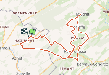
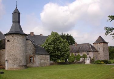
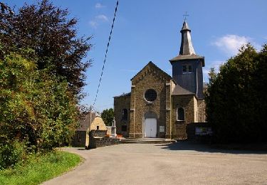
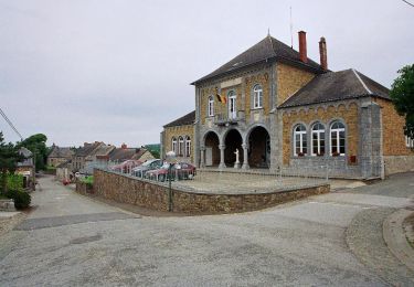
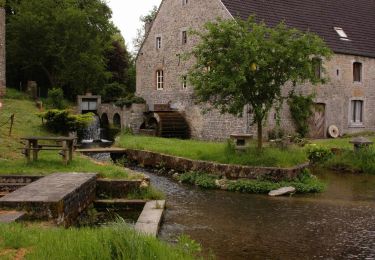
Trail Walking of 23 km to be discovered at Wallonia, Namur, Hamois. This trail is proposed by jeangulu.
Description
Organisateur : LES CULS DE JATTE DU MAUGE _ NA 026.
Marche d'Hiver.
Point de départ : Salle de la Haie Jadot. Rue de la Haie Jadot 5300 - HAMOIS.
Province : Namur.
Entité : HAMOIS.
Carte IGN : 54/2.
Remarque : Parcours très Boueux
Positioning
Country:
Belgium
Region :
Wallonia
Department/Province :
Namur
Municipality :
Hamois
Location:
Unknown
Start:(Dec)
Start:(UTM)
655677 ; 5579611 (31U) N.
Comments
Trails nearby
![Trail Walking Hamois - HAMOIS- Scy (Mohiville)- Promenade du Berceau du Bocq - Photo](https://media.geolcdn.com/t/375/260/ext.jpg?maxdim=2&url=https%3A%2F%2Fservices.sitytrail.com%2FGeolivesWS%2FDownloadMedia.ashx%3FTrailID%3D250701%26Media%3D514f4968-57f7-4b3e-aef8-c121b3f2a3eb.jpg)
![Walking Walking](https://static1.geolcdn.com/sitytour/trail-icons/101.png)
HAMOIS- Scy (Mohiville)- Promenade du Berceau du Bocq
Walking
Easy
(12)
Hamois,
Wallonia,
Namur,
Belgium
![](/images/other/stat-length.png)
7.9 km | 9.8 km-effort
2h 4min
![](https://static1.geolcdn.com/siteimages/upload/files/16400158638029165_repeat_loop_refresh_sync_direction_icon.png)
Yes
![Trail Walking Hamois - HAMOIS- Schaltin- Promenade du Bois du Bocq au Colombier - Photo](https://media.geolcdn.com/t/375/260/ext.jpg?maxdim=2&url=https%3A%2F%2Fservices.sitytrail.com%2FGeolivesWS%2FDownloadMedia.ashx%3FTrailID%3D250699%26Media%3Df5fa6a8e-df6b-4e51-95e3-c58e93d30411.jpg)
![Walking Walking](https://static1.geolcdn.com/sitytour/trail-icons/101.png)
HAMOIS- Schaltin- Promenade du Bois du Bocq au Colombier
Walking
Very easy
(7)
Hamois,
Wallonia,
Namur,
Belgium
![](/images/other/stat-length.png)
4.9 km | 5.8 km-effort
1h 15min
![](https://static1.geolcdn.com/siteimages/upload/files/16400158638029165_repeat_loop_refresh_sync_direction_icon.png)
Yes
![Trail Walking Havelange - HAVELANGE- Flostoy- Promenade de la Caracole - Photo](https://media.geolcdn.com/t/375/260/ext.jpg?maxdim=2&url=https%3A%2F%2Fservices.sitytrail.com%2FGeolivesWS%2FDownloadMedia.ashx%3FTrailID%3D250681%26Media%3Db4692c7d-0045-4942-bb68-c1e9689abc11.jpg)
![Walking Walking](https://static1.geolcdn.com/sitytour/trail-icons/101.png)
HAVELANGE- Flostoy- Promenade de la Caracole
Walking
Very easy
(4)
Havelange,
Wallonia,
Namur,
Belgium
![](/images/other/stat-length.png)
13.2 km | 16.2 km-effort
3h 26min
![](https://static1.geolcdn.com/siteimages/upload/files/16400158638029165_repeat_loop_refresh_sync_direction_icon.png)
Yes
![Trail Walking Hamois - HAMOIS- Hamois- Promenade du Tige al Creûjette - Photo](https://media.geolcdn.com/t/375/260/ext.jpg?maxdim=2&url=https%3A%2F%2Fservices.sitytrail.com%2FGeolivesWS%2FDownloadMedia.ashx%3FTrailID%3D250668%26Media%3D2dcd42b4-7825-4c6c-b964-62af389c92a8.jpg)
![Walking Walking](https://static1.geolcdn.com/sitytour/trail-icons/101.png)
HAMOIS- Hamois- Promenade du Tige al Creûjette
Walking
Very easy
(3)
Hamois,
Wallonia,
Namur,
Belgium
![](/images/other/stat-length.png)
5.2 km | 6.3 km-effort
1h 22min
![](https://static1.geolcdn.com/siteimages/upload/files/16400158638029165_repeat_loop_refresh_sync_direction_icon.png)
Yes
![Trail Walking Hamois - HAMOIS- Achet- Promenade du Chapitre Saint-Paul en Tourlouette - Photo](https://media.geolcdn.com/t/375/260/ext.jpg?maxdim=2&url=https%3A%2F%2Fservices.sitytrail.com%2FGeolivesWS%2FDownloadMedia.ashx%3FTrailID%3D250667%26Media%3D711a5ab0-f1b5-4358-8e7d-16aef65342fb.jpg)
![Walking Walking](https://static1.geolcdn.com/sitytour/trail-icons/101.png)
HAMOIS- Achet- Promenade du Chapitre Saint-Paul en Tourlouette
Walking
Easy
(2)
Hamois,
Wallonia,
Namur,
Belgium
![](/images/other/stat-length.png)
7.3 km | 9 km-effort
1h 52min
![](https://static1.geolcdn.com/siteimages/upload/files/16400158638029165_repeat_loop_refresh_sync_direction_icon.png)
Yes
![Trail Walking Havelange - De Havelange à Saint Fontaine par le village de Ossogne - Photo](https://media.geolcdn.com/t/375/260/04fc6586-f8c4-4d68-9d83-7556d5fef97f.jpg&format=jpg&maxdim=2)
![Walking Walking](https://static1.geolcdn.com/sitytour/trail-icons/101.png)
De Havelange à Saint Fontaine par le village de Ossogne
Walking
Very easy
(1)
Havelange,
Wallonia,
Namur,
Belgium
![](/images/other/stat-length.png)
14.8 km | 18.7 km-effort
6h 27min
![](https://static1.geolcdn.com/siteimages/upload/files/16400158638029165_repeat_loop_refresh_sync_direction_icon.png)
Yes
![Trail Cycle Havelange - HAVELANGE - Circuit de Fermes en Châteaux en Condroz - Photo](https://media.geolcdn.com/t/375/260/ext.jpg?maxdim=2&url=https%3A%2F%2Fstatic1.geolcdn.com%2Fsiteimages%2Fupload%2Ffiles%2F1524743154velo.jpg)
![Cycle Cycle](https://static1.geolcdn.com/sitytour/trail-icons/200.png)
HAVELANGE - Circuit de Fermes en Châteaux en Condroz
Cycle
Very easy
(3)
Havelange,
Wallonia,
Namur,
Belgium
![](/images/other/stat-length.png)
29 km | 34 km-effort
1h 58min
![](https://static1.geolcdn.com/siteimages/upload/files/16400158638029165_repeat_loop_refresh_sync_direction_icon.png)
Yes
![Trail Walking Havelange - HAVELANGE- Promenade de la Pyramide - Photo](https://media.geolcdn.com/t/375/260/ext.jpg?maxdim=2&url=https%3A%2F%2Fservices.sitytrail.com%2FGeolivesWS%2FDownloadMedia.ashx%3FTrailID%3D394816%26Media%3D68124e38-dd6b-4975-9692-b667f0d0811e.jpg)
![Walking Walking](https://static1.geolcdn.com/sitytour/trail-icons/101.png)
HAVELANGE- Promenade de la Pyramide
Walking
Very easy
(2)
Havelange,
Wallonia,
Namur,
Belgium
![](/images/other/stat-length.png)
12.6 km | 15.5 km-effort
3h 22min
![](https://static1.geolcdn.com/siteimages/upload/files/16400158638029165_repeat_loop_refresh_sync_direction_icon.png)
Yes
![Trail Walking Havelange - HAVELANGE- Promenade de la Pyramide - Photo](https://media.geolcdn.com/t/375/260/ext.jpg?maxdim=2&url=https%3A%2F%2Fservices.sitytrail.com%2FGeolivesWS%2FDownloadMedia.ashx%3FTrailID%3D250684%26Media%3D68124e38-dd6b-4975-9692-b667f0d0811e.jpg)
![Walking Walking](https://static1.geolcdn.com/sitytour/trail-icons/101.png)
HAVELANGE- Promenade de la Pyramide
Walking
Very easy
(5)
Havelange,
Wallonia,
Namur,
Belgium
![](/images/other/stat-length.png)
12.6 km | 15.5 km-effort
3h 22min
![](https://static1.geolcdn.com/siteimages/upload/files/16400158638029165_repeat_loop_refresh_sync_direction_icon.png)
Yes