Trail Walking Baugé-en-Anjou - Circuit Les Essarts - Photo
 palmi1
palmi1

User

© OpenStreetMap contributors
Length
Length
14.4 km
Max alt
Max alt
86 m
Uphill gradient
Uphill gradient
175 m
Km-Effort
Km-Effort  
16.8 km
Min alt
Min alt
41 m
Downhill gradient
Downhill gradient
176 m
Boucle
Boucle
Yes
Creation date :
2024-02-02 12:12:52.0
Updated on :
2024-02-02 18:23:22.441

(0 Reviews)

Walking
Walking
6h08
Difficulty : Medium

Scan this QR Code to open this trail in the SityTrail application

FREE GPS app for hiking

Logo SityTrail SityTrail

IGN / Geographical institutes

Download SityTrail from the App Store Download SityTrail from Google Play

Logo SityTrail SityTrail World

The world is yours!

Download SityTrail from the App Store Download SityTrail from Google Play Download SityTrail on Huawei AppGallery

About

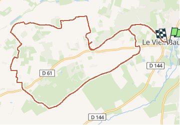
Trail Walking of 14.4 km to be discovered at Pays de la Loire, Maine-et-Loire, Baugé-en-Anjou. This trail is proposed by palmi1.

Description

Le vieil Baugé. Parking aire de picnic.
Balisage jaune.

Elevation profile

Positioning

Country:
France
Region :
Pays de la Loire
Department/Province :
Maine-et-Loire
Municipality :
Baugé-en-Anjou
Location:
Unknown
Start:(UTM)
716858 ; 5268202 (30T) N.

Trails nearby

Trail On foot Baugé-en-Anjou - Circuit d’interprétation « Les Essarts » - Photo
On foot
GUIDE+

On foot

Easy
Baugé-en-Anjou, Pays de la Loire, Maine-et-Loire, France
13.5 km | 15.7 km-effort
3h 34min
Yes
Trail On foot Baugé-en-Anjou - Circuit d’interprétation « La Butte de Rancan » - Photo
On foot
GUIDE+

On foot

Easy
Baugé-en-Anjou, Pays de la Loire, Maine-et-Loire, France
4.7 km | 5.7 km-effort
1h 18min
Yes
Trail Walking Baugé-en-Anjou - Bocé - Photo
Walking
Ennis

Walking

Medium
Baugé-en-Anjou, Pays de la Loire, Maine-et-Loire, France
17.8 km | 20 km-effort
3h 6min
Yes
Trail Walking Baugé-en-Anjou - echemire-menhir-15km - Photo
Walking
bubuserge

Walking

Difficult
Baugé-en-Anjou, Pays de la Loire, Maine-et-Loire, France
14.8 km | 17.3 km-effort
3h 55min
No
Trail Walking Baugé-en-Anjou - gpx-trace - Photo
Walking
bubuserge

Walking

Difficult
Baugé-en-Anjou, Pays de la Loire, Maine-et-Loire, France
11 km | 12.9 km-effort
2h 55min
Yes
Trail Walking Baugé-en-Anjou - LE VIEIL BAUGÉ DEPUIS LE CAMPING DE BAUGÉ-EN-ANJOU  - Photo
Walking
walrou63

Walking

Medium
Baugé-en-Anjou, Pays de la Loire, Maine-et-Loire, France
7.5 km | 8.5 km-effort
1h 55min
Yes
Trail On foot Baugé-en-Anjou - VISITE DU VIEIL BAUGE ET BAUGE EN ANJOU DEPUIS LE CAMPING - Photo
On foot
walrou63

On foot

Easy
Baugé-en-Anjou, Pays de la Loire, Maine-et-Loire, France
7.4 km | 8.4 km-effort
1h 54min
Yes
Trail Walking Baugé-en-Anjou - track - Photo
Walking
bubuserge

Walking

Difficult
Baugé-en-Anjou, Pays de la Loire, Maine-et-Loire, France
11.6 km | 13.4 km-effort
2h 56min
Yes
Trail Other activity Baugé-en-Anjou - Rando des sangliers  - Photo
Other activity
bubuserge

Other activity

Easy
Baugé-en-Anjou, Pays de la Loire, Maine-et-Loire, France
27 km | 30 km-effort
4h 56min
Yes


Close
My subscriptions