![](/images/other/stat-length.png)
![Trail Walking Véronne - 2024-02-02_12h04m54_SityTrail - Tour-du-Barry-depuis-Verone-665 md+ - Photo](https://media.geolcdn.com/t/1900/400/ext.pjpeg?maxdim=2&url=https%3A%2F%2Fstatic1.geolcdn.com%2Fsiteimages%2Fupload%2Ffiles%2F1553511878bg_sport_marche.png)
2024-02-02_12h04m54_SityTrail - Tour-du-Barry-depuis-Verone-665 md+
okfred26
User
![Length](/images/other/stat-length.png)
Length
12.8 km
![Max alt](https://static1.geolcdn.com/siteimages/upload/files/1508320355ic_sort_altitude_max_24dp.png)
Max alt
1072 m
![Uphill gradient](https://static1.geolcdn.com/siteimages/upload/files/1508320355ic_sort_den_pos_24dp.png)
Uphill gradient
665 m
![Km-Effort](/images/other/stat-length.png)
Km-Effort
22 km
![Min alt](https://static1.geolcdn.com/siteimages/upload/files/1508320355ic_sort_altitude_min_24dp.png)
Min alt
511 m
![Downhill gradient](https://static1.geolcdn.com/siteimages/upload/files/1508320355ic_sort_den_neg_24dp.png)
Downhill gradient
675 m
![Boucle](https://static1.geolcdn.com/siteimages/upload/files/16400158638029165_repeat_loop_refresh_sync_direction_icon.png)
Boucle
Yes
Creation date :
2024-02-02 11:04:56.126
Updated on :
2024-02-02 14:11:17.922
![Walking](https://static1.geolcdn.com/sitytour/trail-icons/101.png)
4h55
Difficulty : Very difficult
![Scan this QR Code to open this trail in the SityTrail application](https://capi.geolives.com/qq0zvz2zws4bq2lad0pu/sitytour/trails/3936311/qr.png?size=200)
FREE GPS app for hiking
About
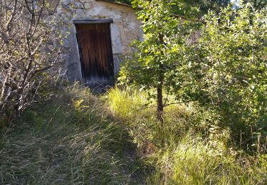
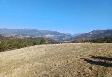
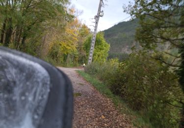
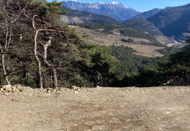
Trail Walking of 12.8 km to be discovered at Auvergne-Rhône-Alpes, Drôme, Véronne. This trail is proposed by okfred26.
Description
Attention ! Après le départ de la chapelle de la Nativité à 1,6 km et sur 20 m passage difficile sur un sentier en devers avec roche très friable et peu stabilisée. risque de chute.
Positioning
Country:
France
Region :
Auvergne-Rhône-Alpes
Department/Province :
Drôme
Municipality :
Véronne
Location:
Unknown
Start:(Dec)
Start:(UTM)
675811 ; 4957650 (31T) N.
Comments
Trails nearby
![Trail Walking Vercheny - Vercheny Chateau du Barry 14 km - Photo](https://media.geolcdn.com/t/375/260/519ec2eb-eec0-4702-a29a-2c5cd69166ae.jpg&format=jpg&maxdim=2)
![Walking Walking](https://static1.geolcdn.com/sitytour/trail-icons/101.png)
Vercheny Chateau du Barry 14 km
Walking
Medium
(1)
Vercheny,
Auvergne-Rhône-Alpes,
Drôme,
France
![](/images/other/stat-length.png)
14.2 km | 23 km-effort
5h 11min
![](https://static1.geolcdn.com/siteimages/upload/files/16400158638029165_repeat_loop_refresh_sync_direction_icon.png)
Yes
![Trail Walking Aurel - Vercors - Vercheny Combe Noire - Photo](https://media.geolcdn.com/t/375/260/ext.jpg?maxdim=2&url=https%3A%2F%2Fstatic1.geolcdn.com%2Fsiteimages%2Fupload%2Ffiles%2F1553511878bg_sport_marche.png)
![Walking Walking](https://static1.geolcdn.com/sitytour/trail-icons/101.png)
Vercors - Vercheny Combe Noire
Walking
Very easy
(1)
Aurel,
Auvergne-Rhône-Alpes,
Drôme,
France
![](/images/other/stat-length.png)
8.7 km | 12.7 km-effort
2h 55min
![](https://static1.geolcdn.com/siteimages/upload/files/16400158638029165_repeat_loop_refresh_sync_direction_icon.png)
Yes
![Trail Walking Pontaix - 26 pontaix gaudichard HS danger - Photo](https://media.geolcdn.com/t/375/260/183d0205-1205-4f53-b493-02d41fe7f23f.jpg&format=jpg&maxdim=2)
![Walking Walking](https://static1.geolcdn.com/sitytour/trail-icons/101.png)
26 pontaix gaudichard HS danger
Walking
Medium
Pontaix,
Auvergne-Rhône-Alpes,
Drôme,
France
![](/images/other/stat-length.png)
16.2 km | 28 km-effort
7h 18min
![](https://static1.geolcdn.com/siteimages/upload/files/16400158638029165_repeat_loop_refresh_sync_direction_icon.png)
Yes
![Trail Walking Pontaix - Portail - Photo](https://media.geolcdn.com/t/375/260/66e92e73-f886-4c5a-a3ed-b850f5ded1bb.jpg&format=jpg&maxdim=2)
![Walking Walking](https://static1.geolcdn.com/sitytour/trail-icons/101.png)
Portail
Walking
Medium
Pontaix,
Auvergne-Rhône-Alpes,
Drôme,
France
![](/images/other/stat-length.png)
16.6 km | 23 km-effort
5h 30min
![](https://static1.geolcdn.com/siteimages/upload/files/16400158638029165_repeat_loop_refresh_sync_direction_icon.png)
No
![Trail Road bike Pontaix - 26 eygluy st julien en Q Marignac velo - Photo](https://media.geolcdn.com/t/375/260/a7db403b-1f5a-4331-b4cb-49c0c6455ceb.jpg&format=jpg&maxdim=2)
![Road bike Road bike](https://static1.geolcdn.com/sitytour/trail-icons/201.png)
26 eygluy st julien en Q Marignac velo
Road bike
Medium
Pontaix,
Auvergne-Rhône-Alpes,
Drôme,
France
![](/images/other/stat-length.png)
77 km | 99 km-effort
6h 20min
![](https://static1.geolcdn.com/siteimages/upload/files/16400158638029165_repeat_loop_refresh_sync_direction_icon.png)
Yes
![Trail Walking Sainte-Croix - 26 Sainte Croix Crêtes de Ramiat - Photo](https://media.geolcdn.com/t/375/260/203a62f6-fb85-4425-89b0-bab28fcb9e6a.jpg&format=jpg&maxdim=2)
![Walking Walking](https://static1.geolcdn.com/sitytour/trail-icons/101.png)
26 Sainte Croix Crêtes de Ramiat
Walking
Very difficult
Sainte-Croix,
Auvergne-Rhône-Alpes,
Drôme,
France
![](/images/other/stat-length.png)
17.5 km | 30 km-effort
6h 42min
![](https://static1.geolcdn.com/siteimages/upload/files/16400158638029165_repeat_loop_refresh_sync_direction_icon.png)
Yes
![Trail Walking Vercheny - Vercheny boucle du Barry - Photo](https://media.geolcdn.com/t/375/260/45cc04fa-8610-40bb-9c86-b51ae560d7da.jpg&format=jpg&maxdim=2)
![Walking Walking](https://static1.geolcdn.com/sitytour/trail-icons/101.png)
Vercheny boucle du Barry
Walking
Medium
Vercheny,
Auvergne-Rhône-Alpes,
Drôme,
France
![](/images/other/stat-length.png)
12.8 km | 21 km-effort
3h 41min
![](https://static1.geolcdn.com/siteimages/upload/files/16400158638029165_repeat_loop_refresh_sync_direction_icon.png)
Yes
![Trail Walking Vercheny - vercheny château du barry - Photo](https://media.geolcdn.com/t/375/260/ext.jpg?maxdim=2&url=https%3A%2F%2Fstatic1.geolcdn.com%2Fsiteimages%2Fupload%2Ffiles%2F1553511878bg_sport_marche.png)
![Walking Walking](https://static1.geolcdn.com/sitytour/trail-icons/101.png)
vercheny château du barry
Walking
Medium
(1)
Vercheny,
Auvergne-Rhône-Alpes,
Drôme,
France
![](/images/other/stat-length.png)
16.5 km | 26 km-effort
6h 33min
![](https://static1.geolcdn.com/siteimages/upload/files/16400158638029165_repeat_loop_refresh_sync_direction_icon.png)
Yes
![Trail Walking Pontaix - Pontaix ste Croix randoN1 - Photo](https://media.geolcdn.com/t/375/260/22352052-25e2-4ad1-b1d0-a12507dbd1da.jpg&format=jpg&maxdim=2)
![Walking Walking](https://static1.geolcdn.com/sitytour/trail-icons/101.png)
Pontaix ste Croix randoN1
Walking
Medium
Pontaix,
Auvergne-Rhône-Alpes,
Drôme,
France
![](/images/other/stat-length.png)
11.5 km | 17.7 km-effort
5h 52min
![](https://static1.geolcdn.com/siteimages/upload/files/16400158638029165_repeat_loop_refresh_sync_direction_icon.png)
No