Trail Walking La Penne - Col Saint-Raphael en boucle - Photo
 dan0406
dan0406

User

© OpenStreetMap contributors
Length
Length
12.1 km
Max alt
Max alt
1078 m
Uphill gradient
Uphill gradient
543 m
Km-Effort
Km-Effort  
19.3 km
Min alt
Min alt
732 m
Downhill gradient
Downhill gradient
533 m
Boucle
Boucle
Yes
Creation date :
2024-01-26 08:22:58.647
Updated on :
2024-01-26 09:16:25.125

(0 Reviews)

Walking
Walking
4h23
Difficulty : Very difficult

Scan this QR Code to open this trail in the SityTrail application

FREE GPS app for hiking

Logo SityTrail SityTrail

IGN / Geographical institutes

Download SityTrail from the App Store Download SityTrail from Google Play

Logo SityTrail SityTrail World

The world is yours!

Download SityTrail from the App Store Download SityTrail from Google Play Download SityTrail on Huawei AppGallery

About

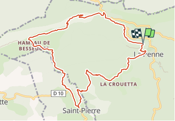
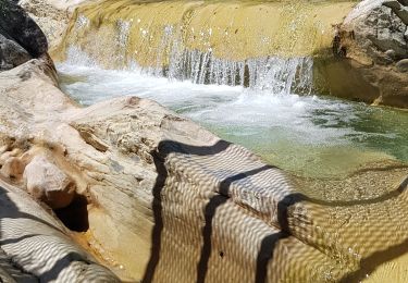
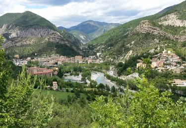
Trail Walking of 12.1 km to be discovered at Provence-Alpes-Côte d'Azur, Maritime Alps, La Penne. This trail is proposed by dan0406.

Description

Col SaintRaphael, une boucle par le Col de Besseuges, Saint-Pierre, La Penne, retour au Col Saint-Raphael

Elevation profile

Positioning

Country:
France
Region :
Provence-Alpes-Côte d'Azur
Department/Province :
Maritime Alps
Municipality :
La Penne
Location:
Unknown
Start:(UTM)
335112 ; 4866176 (32T) N.

Trails nearby

Trail On foot Puget-Théniers - Circuit des Aubrics - Photo
On foot
GUIDE+

On foot

Easy
Puget-Théniers, Provence-Alpes-Côte d'Azur, Maritime Alps, France
6.3 km | 11.8 km-effort
2h 40min
Yes
Trail Walking Puget-Théniers - Puget théniers-Entrevaux par le col de Vélacs - Photo
Walking
PEBREJOSIANE

Walking

Medium
(1)
Puget-Théniers, Provence-Alpes-Côte d'Azur, Maritime Alps, France
14.3 km | 25 km-effort
6h 10min
No
Trail On foot Touët-sur-Var - Traversée Touët-sur-Var – Villars-sur-Var - Photo
On foot
GUIDE+

On foot

Medium
Touët-sur-Var, Provence-Alpes-Côte d'Azur, Maritime Alps, France
13.9 km | 25 km-effort
5h 35min
No
Trail On foot Puget-Rostang - Circuit de Mairola - Photo
On foot
GUIDE+

On foot

Medium
Puget-Rostang, Provence-Alpes-Côte d'Azur, Maritime Alps, France
11.4 km | 23 km-effort
5h 11min
Yes
Trail Walking Puget-Rostang - Puget Rostang à Auvare - Photo
Walking
MIKARANDO

Walking

Difficult
Puget-Rostang, Provence-Alpes-Côte d'Azur, Maritime Alps, France
12.2 km | 24 km-effort
3h 53min
Yes
Trail Walking Touët-sur-Var - Touet sur Var vers Villars sur Var - Photo
Walking
patsure

Walking

Medium
Touët-sur-Var, Provence-Alpes-Côte d'Azur, Maritime Alps, France
15.6 km | 28 km-effort
4h 45min
No
Trail Walking Touët-sur-Var - Touet sur Var vers Villars sur Var - Photo
Walking
patsure

Walking

Medium
Touët-sur-Var, Provence-Alpes-Côte d'Azur, Maritime Alps, France
15.6 km | 0 m-effort
4h 45min
No
Trail Walking Puget-Théniers - Puget-Théniers - 2016 06 15 - Photo
Walking
GUIDE
Orcal37

Walking

Easy
Puget-Théniers, Provence-Alpes-Côte d'Azur, Maritime Alps, France
15.3 km | 21 km-effort
4h 0min
Yes
Trail Walking Puget-Théniers - Traversée Puget Entrevaux - Photo
Walking
xelot

Walking

Easy
(1)
Puget-Théniers, Provence-Alpes-Côte d'Azur, Maritime Alps, France
12.7 km | 24 km-effort
4h 57min
No


Close
My subscriptions