Trail Snowshoes Bardonecchia - val susa : bardonecchia :pian de colle -refugi très magi vallée etroite - Photo

val susa : bardonecchia :pian de colle -refugi très magi vallée etroite

© OpenStreetMap contributors
Length
Length
5.4 km
Max alt
Max alt
1769 m
Uphill gradient
Uphill gradient
316 m
Km-Effort
Km-Effort  
8.5 km
Min alt
Min alt
1455 m
Downhill gradient
Downhill gradient
6 m
Boucle
Boucle
No
Creation date :
2024-01-24 09:58:43.599
Updated on :
2024-01-24 16:31:16.236

(0 Reviews)

Snowshoes
Snowshoes
1h38
Difficulty : Easy

Scan this QR Code to open this trail in the SityTrail application

FREE GPS app for hiking

Logo SityTrail SityTrail

IGN / Geographical institutes

Download SityTrail from the App Store Download SityTrail from Google Play

Logo SityTrail SityTrail World

The world is yours!

Download SityTrail from the App Store Download SityTrail from Google Play Download SityTrail on Huawei AppGallery

About

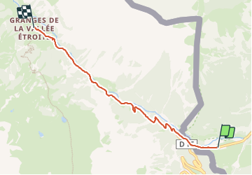
Trail Snowshoes of 5.4 km to be discovered at Piemont, Torino, Bardonecchia. This trail is proposed by lebarbe_b@hotmail.fr.

Description

randonnée 24 janvier : nota : parcours a l'ombre toute la montée ,soleil en arrivant aux granges

Elevation profile

Positioning

Country:
Italy
Region :
Piemont
Department/Province :
Torino
Municipality :
Bardonecchia
Location:
Unknown
Start:(UTM)
316343 ; 4991141 (32T) N.

Trails nearby

Trail Walking Névache - Lac Vert.Vallée Etroite.(27-09-17) - Photo
Walking
Dervalmarc

Walking

Very easy
(1)
Névache, Provence-Alpes-Côte d'Azur, Hautes-Alpes, France
4.2 km | 5.9 km-effort
1h 19min
Yes
Trail Walking Névache - les granges de la vallée étroite au refuge du Mont Thabor - Photo
Walking
reneperrin

Walking

Easy
(1)
Névache, Provence-Alpes-Côte d'Azur, Hautes-Alpes, France
8.6 km | 16.2 km-effort
3h 44min
No
Trail Mountain bike Névache - Tour des Rois Mages en VTT - Névache - Photo
Mountain bike
tracegps

Mountain bike

Difficult
(2)
Névache, Provence-Alpes-Côte d'Azur, Hautes-Alpes, France
35 km | 55 km-effort
5h 0min
Yes
Trail Walking Névache - Via Alpina - R127: Névache > Le Monêtier-les-Bains - Photo
Walking
tracegps

Walking

Difficult
(1)
Névache, Provence-Alpes-Côte d'Azur, Hautes-Alpes, France
15.5 km | 28 km-effort
5h 0min
No
Trail Walking Névache - Gardiette  - Photo
Walking
GUIDE
jouans

Walking

Easy
Névache, Provence-Alpes-Côte d'Azur, Hautes-Alpes, France
16.6 km | 32 km-effort
7h 33min
Yes
Trail Walking Névache - le Mont Thabor - Photo
Walking
GUIDE
amiral13

Walking

Difficult
Névache, Provence-Alpes-Côte d'Azur, Hautes-Alpes, France
19.9 km | 40 km-effort
8h 44min
Yes
Trail Walking Névache - L'Aiguille rouge et Lac Chavillon : Panorama sur la vallée de la Clarée - Photo
Walking
GUIDE
Pierre Lefèvre

Walking

Very difficult
Névache, Provence-Alpes-Côte d'Azur, Hautes-Alpes, France
15.4 km | 29 km-effort
6h 29min
Yes
Trail Walking Névache - Boucle au dessus de Névache par le Refuge de Buffère et Côte Rouge - Photo
Walking
GUIDE
Pierre Lefèvre

Walking

Very difficult
Névache, Provence-Alpes-Côte d'Azur, Hautes-Alpes, France
14.8 km | 24 km-effort
5h 26min
Yes
Trail Walking Névache - lac de Cristol,, Nevache  - Photo
Walking
okfred26

Walking

Very difficult
(1)
Névache, Provence-Alpes-Côte d'Azur, Hautes-Alpes, France
11.2 km | 22 km-effort
4h 55min
Yes


Close
My subscriptions