![](/images/other/stat-length.png)
![Trail On foot Flayosc - Tracé actuel: 08 FEV 2023 14:16 - Photo](https://media.geolcdn.com/t/1900/400/ext.pjpeg?maxdim=2&url=https%3A%2F%2Fstatic1.geolcdn.com%2Fsiteimages%2Fupload%2Ffiles%2F1545311037marcheuse_200dpi.jpg)
Tracé actuel: 08 FEV 2023 14:16
felix83
User
![Length](/images/other/stat-length.png)
Length
6.9 km
![Max alt](https://static1.geolcdn.com/siteimages/upload/files/1508320355ic_sort_altitude_max_24dp.png)
Max alt
388 m
![Uphill gradient](https://static1.geolcdn.com/siteimages/upload/files/1508320355ic_sort_den_pos_24dp.png)
Uphill gradient
77 m
![Km-Effort](/images/other/stat-length.png)
Km-Effort
8 km
![Min alt](https://static1.geolcdn.com/siteimages/upload/files/1508320355ic_sort_altitude_min_24dp.png)
Min alt
334 m
![Downhill gradient](https://static1.geolcdn.com/siteimages/upload/files/1508320355ic_sort_den_neg_24dp.png)
Downhill gradient
77 m
![Boucle](https://static1.geolcdn.com/siteimages/upload/files/16400158638029165_repeat_loop_refresh_sync_direction_icon.png)
Boucle
Yes
Creation date :
2024-01-24 14:46:36.542
Updated on :
2024-01-24 14:57:11.554
![On foot](https://static1.geolcdn.com/sitytour/trail-icons/100.png)
1h48
Difficulty : Easy
![Scan this QR Code to open this trail in the SityTrail application](https://capi.geolives.com/qq0zvz2zws4bq2lad0pu/sitytour/trails/3926180/qr.png?size=200)
FREE GPS app for hiking
About
Trail On foot of 6.9 km to be discovered at Provence-Alpes-Côte d'Azur, Var, Flayosc. This trail is proposed by felix83.
Description
Petite randonnée sans difficulté dans la forêt de Flayosc (83).
Staionnement des voitures possible sur le bord de la départementale D557 (Route de Salernes)
Positioning
Country:
France
Region :
Provence-Alpes-Côte d'Azur
Department/Province :
Var
Municipality :
Flayosc
Location:
Unknown
Start:(Dec)
Start:(UTM)
283515 ; 4824813 (32T) N.
Comments
Trails nearby
![Trail Walking Villecroze - 2023-10-31 Villecroz - Tourtour et tourisme - Photo](https://media.geolcdn.com/t/375/260/f84ff7d5-400b-494e-8808-c59b480ad1f2.jpg&format=jpg&maxdim=2)
![Walking Walking](https://static1.geolcdn.com/sitytour/trail-icons/101.png)
2023-10-31 Villecroz - Tourtour et tourisme
Walking
Medium
Villecroze,
Provence-Alpes-Côte d'Azur,
Var,
France
![](/images/other/stat-length.png)
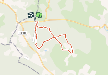
17.6 km | 24 km-effort
5h 28min
![](https://static1.geolcdn.com/siteimages/upload/files/16400158638029165_repeat_loop_refresh_sync_direction_icon.png)
Yes
![Trail Walking Villecroze - Villecroze de Chapelles en Grottes - Photo](https://media.geolcdn.com/t/375/260/b4f00218-714a-4329-ac66-fe1861cf789d.jpg&format=jpg&maxdim=2)
![Walking Walking](https://static1.geolcdn.com/sitytour/trail-icons/101.png)
Villecroze de Chapelles en Grottes
Walking
Very difficult
Villecroze,
Provence-Alpes-Côte d'Azur,
Var,
France
![](/images/other/stat-length.png)
19.9 km | 28 km-effort
5h 49min
![](https://static1.geolcdn.com/siteimages/upload/files/16400158638029165_repeat_loop_refresh_sync_direction_icon.png)
Yes
![Trail Walking Tourtour - Tourtour - Les Moulières - Photo](https://media.geolcdn.com/t/375/260/ext.jpg?maxdim=2&url=https%3A%2F%2Fstatic1.geolcdn.com%2Fsiteimages%2Fupload%2Ffiles%2F1553511878bg_sport_marche.png)
![Walking Walking](https://static1.geolcdn.com/sitytour/trail-icons/101.png)
Tourtour - Les Moulières
Walking
Medium
(1)
Tourtour,
Provence-Alpes-Côte d'Azur,
Var,
France
![](/images/other/stat-length.png)
13.1 km | 15.6 km-effort
5h 0min
![](https://static1.geolcdn.com/siteimages/upload/files/16400158638029165_repeat_loop_refresh_sync_direction_icon.png)
Yes
![Trail Other activity Villecroze - fox - Photo](https://media.geolcdn.com/t/375/260/ext.jpg?maxdim=2&url=https%3A%2F%2Fstatic1.geolcdn.com%2Fsiteimages%2Fupload%2Ffiles%2F1545311037marcheuse_200dpi.jpg)
![Other activity Other activity](https://static1.geolcdn.com/sitytour/trail-icons/900.png)
fox
Other activity
Medium
(1)
Villecroze,
Provence-Alpes-Côte d'Azur,
Var,
France
![](/images/other/stat-length.png)
42 km | 52 km-effort
2h 24min
![](https://static1.geolcdn.com/siteimages/upload/files/16400158638029165_repeat_loop_refresh_sync_direction_icon.png)
Yes
![Trail Mountain bike Villecroze - st bart - Photo](https://media.geolcdn.com/t/375/260/ext.jpg?maxdim=2&url=https%3A%2F%2Fstatic1.geolcdn.com%2Fsiteimages%2Fupload%2Ffiles%2F1524743154velo.jpg)
![Mountain bike Mountain bike](https://static1.geolcdn.com/sitytour/trail-icons/202.png)
st bart
Mountain bike
Difficult
(1)
Villecroze,
Provence-Alpes-Côte d'Azur,
Var,
France
![](/images/other/stat-length.png)
33 km | 42 km-effort
2h 20min
![](https://static1.geolcdn.com/siteimages/upload/files/16400158638029165_repeat_loop_refresh_sync_direction_icon.png)
Yes
![Trail Mountain bike Villecroze - giant vs haibike - Photo](https://media.geolcdn.com/t/375/260/ext.jpg?maxdim=2&url=https%3A%2F%2Fstatic1.geolcdn.com%2Fsiteimages%2Fupload%2Ffiles%2F1524743154velo.jpg)
![Mountain bike Mountain bike](https://static1.geolcdn.com/sitytour/trail-icons/202.png)
giant vs haibike
Mountain bike
Medium
(1)
Villecroze,
Provence-Alpes-Côte d'Azur,
Var,
France
![](/images/other/stat-length.png)
29 km | 36 km-effort
1h 49min
![](https://static1.geolcdn.com/siteimages/upload/files/16400158638029165_repeat_loop_refresh_sync_direction_icon.png)
Yes
![Trail Walking Villecroze - VILLECROZE TOURTOUR N - Photo](https://media.geolcdn.com/t/375/260/599e5e7e-da69-49e5-8690-f7d254b7e4d2.jpg&format=jpg&maxdim=2)
![Walking Walking](https://static1.geolcdn.com/sitytour/trail-icons/101.png)
VILLECROZE TOURTOUR N
Walking
Very difficult
Villecroze,
Provence-Alpes-Côte d'Azur,
Var,
France
![](/images/other/stat-length.png)
15.1 km | 21 km-effort
4h 33min
![](https://static1.geolcdn.com/siteimages/upload/files/16400158638029165_repeat_loop_refresh_sync_direction_icon.png)
Yes
![Trail Walking Villecroze - Villecroze- Domaine Saint Jean - Photo](https://media.geolcdn.com/t/375/260/1159e4c7-252a-4789-9dc1-6697f859dafa.jpg&format=jpg&maxdim=2)
![Walking Walking](https://static1.geolcdn.com/sitytour/trail-icons/101.png)
Villecroze- Domaine Saint Jean
Walking
Easy
Villecroze,
Provence-Alpes-Côte d'Azur,
Var,
France
![](/images/other/stat-length.png)
4.3 km | 5.4 km-effort
1h 16min
![](https://static1.geolcdn.com/siteimages/upload/files/16400158638029165_repeat_loop_refresh_sync_direction_icon.png)
No
![Trail sport Saint-Antonin-du-Var - 2024-02-05_17h29m21_st antonin demain - Photo](https://media.geolcdn.com/t/375/260/ext.jpg?maxdim=2&url=https%3A%2F%2Fsecurestorage.geolives.com%2Fsitytour%2Ftrail-bg%2Fdefault.jpg)
2024-02-05_17h29m21_st antonin demain
sport
Very easy
(1)
Saint-Antonin-du-Var,
Provence-Alpes-Côte d'Azur,
Var,
France
![](/images/other/stat-length.png)
27 km | 35 km-effort
Unknown
![](https://static1.geolcdn.com/siteimages/upload/files/16400158638029165_repeat_loop_refresh_sync_direction_icon.png)
Yes