![Trail Motorbike Paracas - paracas - Photo](https://media.geolcdn.com/t/1900/400/ext.pjpeg?maxdim=2&url=https%3A%2F%2Fstatic1.geolcdn.com%2Fsiteimages%2Fupload%2Ffiles%2F1524743155moto.jpg)
paracas
HENRYLESTEL
User
![Length](/images/other/stat-length.png)
Length
14.8 km
![Max alt](https://static1.geolcdn.com/siteimages/upload/files/1508320355ic_sort_altitude_max_24dp.png)
Max alt
47 m
![Uphill gradient](https://static1.geolcdn.com/siteimages/upload/files/1508320355ic_sort_den_pos_24dp.png)
Uphill gradient
148 m
![Km-Effort](/images/other/stat-length.png)
Km-Effort
16.9 km
![Min alt](https://static1.geolcdn.com/siteimages/upload/files/1508320355ic_sort_altitude_min_24dp.png)
Min alt
-1 m
![Downhill gradient](https://static1.geolcdn.com/siteimages/upload/files/1508320355ic_sort_den_neg_24dp.png)
Downhill gradient
159 m
![Boucle](https://static1.geolcdn.com/siteimages/upload/files/16400158638029165_repeat_loop_refresh_sync_direction_icon.png)
Boucle
No
Creation date :
2024-01-23 20:33:23.713
Updated on :
2024-01-23 21:06:31.211
![Motorbike](https://static1.geolcdn.com/sitytour/trail-icons/402.png)
32m
Difficulty : Very easy
![Scan this QR Code to open this trail in the SityTrail application](https://capi.geolives.com/qq0zvz2zws4bq2lad0pu/sitytour/trails/3925503/qr.png?size=200)
FREE GPS app for hiking
About
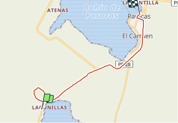
Trail Motorbike of 14.8 km to be discovered at Ica, Province of Pisco, Paracas. This trail is proposed by HENRYLESTEL.
Positioning
Country:
Peru
Region :
Ica
Department/Province :
Province of Pisco
Municipality :
Paracas
Location:
Unknown
Start:(Dec)
Start:(UTM)
357688 ; 8463110 (18L) S.
Comments
Trails nearby