![](/images/other/stat-length.png)
![Trail Walking Lincent - Tracé - Photo](https://media.geolcdn.com/t/1900/400/faf80b17-1570-4cc5-b12c-6b2c2f9baa8b.jpeg&format=pjpeg&maxdim=2)
Tracé
jipysn
User
![Length](/images/other/stat-length.png)
![Max alt](https://static1.geolcdn.com/siteimages/upload/files/1508320355ic_sort_altitude_max_24dp.png)
![Uphill gradient](https://static1.geolcdn.com/siteimages/upload/files/1508320355ic_sort_den_pos_24dp.png)
![Km-Effort](/images/other/stat-length.png)
![Min alt](https://static1.geolcdn.com/siteimages/upload/files/1508320355ic_sort_altitude_min_24dp.png)
![Downhill gradient](https://static1.geolcdn.com/siteimages/upload/files/1508320355ic_sort_den_neg_24dp.png)
![Boucle](https://static1.geolcdn.com/siteimages/upload/files/16400158638029165_repeat_loop_refresh_sync_direction_icon.png)
![Walking](https://static1.geolcdn.com/sitytour/trail-icons/101.png)
1h27
Difficulty : Very easy
![Scan this QR Code to open this trail in the SityTrail application](https://capi.geolives.com/qq0zvz2zws4bq2lad0pu/sitytour/trails/3925402/qr.png?size=200)
FREE GPS app for hiking
About
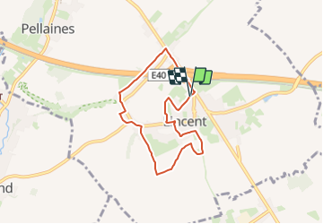
Trail Walking of 5.7 km to be discovered at Wallonia, Liège, Lincent. This trail is proposed by jipysn.
Description
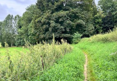
La promenade du Tuffeau est constituée de chemins parfois abrupts . Ce circuit tranquille et paisible passe aussi bien par des chavées ombragées que dans le village . Il s’agit d’un parcours intéressant qui vous permettra de garder la forme .
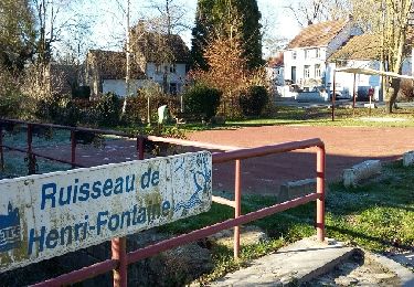
Point de départ:
Maison Communale - rue des Ecoles , 1
Balisage: 🟥.
Positioning
Comments
Trails nearby
![Trail Walking Orp-Jauche - RB-BW-01 - Raccourci 1- L'Extrême-Orient du Brabant wallon - Photo](https://media.geolcdn.com/t/375/260/ext.jpg?maxdim=2&url=https%3A%2F%2Fservices.sitytrail.com%2FGeolivesWS%2FDownloadMedia.ashx%3FTrailID%3D218532%26Media%3D2b25bbe0-0fd5-407f-bf14-f349bb03461d.jpg)
![Walking Walking](https://static1.geolcdn.com/sitytour/trail-icons/101.png)
Walking
![](/images/other/stat-length.png)
![](https://static1.geolcdn.com/siteimages/upload/files/16400158638029165_repeat_loop_refresh_sync_direction_icon.png)
![Trail Walking Orp-Jauche - RB-Bw-01 - Orp-le-Grand via la variante - Photo](https://media.geolcdn.com/t/375/260/ext.jpg?maxdim=2&url=https%3A%2F%2Fservices.sitytrail.com%2FGeolivesWS%2FDownloadMedia.ashx%3FTrailID%3D179575%26Media%3D1fb01559-2292-4faf-8acf-655ff0b406da.jpg)
![Walking Walking](https://static1.geolcdn.com/sitytour/trail-icons/101.png)
Walking
![](/images/other/stat-length.png)
![](https://static1.geolcdn.com/siteimages/upload/files/16400158638029165_repeat_loop_refresh_sync_direction_icon.png)
![Trail Walking Hannut - La Balade des Deux Vallées - Photo](https://media.geolcdn.com/t/375/260/bf859057-7cb9-4d70-a913-bf32ef5ee4d0.jpeg&format=jpg&maxdim=2)
![Walking Walking](https://static1.geolcdn.com/sitytour/trail-icons/101.png)
Walking
![](/images/other/stat-length.png)
![](https://static1.geolcdn.com/siteimages/upload/files/16400158638029165_repeat_loop_refresh_sync_direction_icon.png)
![Trail Walking Orp-Jauche - RB-BW-01 - Raccourci 2- L'Extrême-Orient du Brabant wallon - Photo](https://media.geolcdn.com/t/375/260/ext.jpg?maxdim=2&url=https%3A%2F%2Fservices.sitytrail.com%2FGeolivesWS%2FDownloadMedia.ashx%3FTrailID%3D218537%26Media%3D2b25bbe0-0fd5-407f-bf14-f349bb03461d.jpg)
![Walking Walking](https://static1.geolcdn.com/sitytour/trail-icons/101.png)
Walking
![](/images/other/stat-length.png)
![](https://static1.geolcdn.com/siteimages/upload/files/16400158638029165_repeat_loop_refresh_sync_direction_icon.png)
![Trail Walking Orp-Jauche - Orp le Grand Nathalie Demain 29 11 2016 - Photo](https://media.geolcdn.com/t/375/260/ext.jpg?maxdim=2&url=https%3A%2F%2Fservices.sitytrail.com%2FGeolivesWS%2FDownloadMedia.ashx%3FTrailID%3D666139%26Media%3Dfix__20161129124748.jpg)
![Walking Walking](https://static1.geolcdn.com/sitytour/trail-icons/101.png)
Walking
![](/images/other/stat-length.png)
![](https://static1.geolcdn.com/siteimages/upload/files/16400158638029165_repeat_loop_refresh_sync_direction_icon.png)
![Trail On foot Hélécine - Promenade de la colombe - Photo](https://media.geolcdn.com/t/375/260/0e42a69d-2b43-4abc-b8c8-f2acea9608dc.jpeg&format=jpg&maxdim=2)
![On foot On foot](https://static1.geolcdn.com/sitytour/trail-icons/100.png)
On foot
![](/images/other/stat-length.png)
![](https://static1.geolcdn.com/siteimages/upload/files/16400158638029165_repeat_loop_refresh_sync_direction_icon.png)
![Trail On foot Hélécine - Promenade de la colombe (alternative) - Photo](https://media.geolcdn.com/t/375/260/0e42a69d-2b43-4abc-b8c8-f2acea9608dc.jpeg&format=jpg&maxdim=2)
![On foot On foot](https://static1.geolcdn.com/sitytour/trail-icons/100.png)
On foot
![](/images/other/stat-length.png)
![](https://static1.geolcdn.com/siteimages/upload/files/16400158638029165_repeat_loop_refresh_sync_direction_icon.png)
![Trail On foot Hélécine - Promenade des chavées - Photo](https://media.geolcdn.com/t/375/260/0e42a69d-2b43-4abc-b8c8-f2acea9608dc.jpeg&format=jpg&maxdim=2)
![On foot On foot](https://static1.geolcdn.com/sitytour/trail-icons/100.png)
On foot
![](/images/other/stat-length.png)
![](https://static1.geolcdn.com/siteimages/upload/files/16400158638029165_repeat_loop_refresh_sync_direction_icon.png)
![Trail On foot Hélécine - Promenade des chavées (alternative 1) - Photo](https://media.geolcdn.com/t/375/260/0e42a69d-2b43-4abc-b8c8-f2acea9608dc.jpeg&format=jpg&maxdim=2)
![On foot On foot](https://static1.geolcdn.com/sitytour/trail-icons/100.png)
On foot
![](/images/other/stat-length.png)
![](https://static1.geolcdn.com/siteimages/upload/files/16400158638029165_repeat_loop_refresh_sync_direction_icon.png)