![](/images/other/stat-length.png)
![Trail Walking Châteaudouble - Châteaudouble-L'homme mort - Photo](https://media.geolcdn.com/t/1900/400/ext.pjpeg?maxdim=2&url=https%3A%2F%2Fservices.sitytrail.com%2FGeolivesWS%2FDownloadMedia.ashx%3FTrailID%3D392246%26Media%3Dfix__20150304094655.jpg)
Châteaudouble-L'homme mort
Sugg
User
![Length](/images/other/stat-length.png)
Length
14.5 km
![Max alt](https://static1.geolcdn.com/siteimages/upload/files/1508320355ic_sort_altitude_max_24dp.png)
Max alt
643 m
![Uphill gradient](https://static1.geolcdn.com/siteimages/upload/files/1508320355ic_sort_den_pos_24dp.png)
Uphill gradient
230 m
![Km-Effort](/images/other/stat-length.png)
Km-Effort
17.5 km
![Min alt](https://static1.geolcdn.com/siteimages/upload/files/1508320355ic_sort_altitude_min_24dp.png)
Min alt
514 m
![Downhill gradient](https://static1.geolcdn.com/siteimages/upload/files/1508320355ic_sort_den_neg_24dp.png)
Downhill gradient
229 m
![Boucle](https://static1.geolcdn.com/siteimages/upload/files/16400158638029165_repeat_loop_refresh_sync_direction_icon.png)
Boucle
Yes
Creation date :
2019-03-22 16:59:47.324
Updated on :
2019-03-22 16:59:47.531
![Walking](https://static1.geolcdn.com/sitytour/trail-icons/101.png)
3h52
Difficulty : Easy
![Scan this QR Code to open this trail in the SityTrail application](https://capi.geolives.com/qq0zvz2zws4bq2lad0pu/sitytour/trails/392246/qr.png?size=200)
FREE GPS app for hiking
About
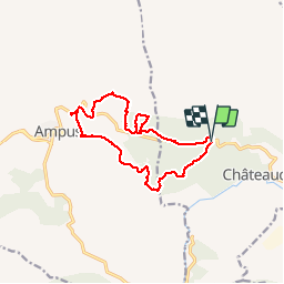
Trail Walking of 14.5 km to be discovered at Provence-Alpes-Côte d'Azur, Var, Châteaudouble. This trail is proposed by Sugg.
Description
04 Mars 2015
Rando groupe 1 de Restons en Forme.
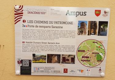
Parcours définitif après 2 reco car beaucoup de pistes ne figurent pas sur la carte.
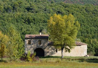
Pique-nique à la chapelle st Michel et au soleil !
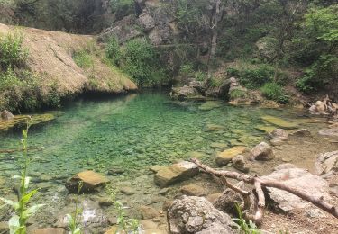
La partie Sud est magnifique et longe les gorges de la Nartuby d'Ampus.
Positioning
Country:
France
Region :
Provence-Alpes-Côte d'Azur
Department/Province :
Var
Municipality :
Châteaudouble
Location:
Unknown
Start:(Dec)
Start:(UTM)
292717 ; 4831102 (32T) N.
Comments
Trails nearby
![Trail Walking Ampus - Ampus-Spéluque - Photo](https://media.geolcdn.com/t/375/260/ext.jpg?maxdim=2&url=https%3A%2F%2Fservices.sitytrail.com%2FGeolivesWS%2FDownloadMedia.ashx%3FTrailID%3D524083%26Media%3D1bf67c76-80de-46cf-8ba1-3400b0f4e108.jpg)
![Walking Walking](https://static1.geolcdn.com/sitytour/trail-icons/101.png)
Ampus-Spéluque
Walking
Easy
(2)
Ampus,
Provence-Alpes-Côte d'Azur,
Var,
France
![](/images/other/stat-length.png)
10.1 km | 13.3 km-effort
2h 54min
![](https://static1.geolcdn.com/siteimages/upload/files/16400158638029165_repeat_loop_refresh_sync_direction_icon.png)
Yes
![Trail Walking Figanières - château château de château de la garde - Photo](https://media.geolcdn.com/t/375/260/ext.jpg?maxdim=2&url=https%3A%2F%2Fstatic1.geolcdn.com%2Fsiteimages%2Fupload%2Ffiles%2F1553511878bg_sport_marche.png)
![Walking Walking](https://static1.geolcdn.com/sitytour/trail-icons/101.png)
château château de château de la garde
Walking
Very easy
(1)
Figanières,
Provence-Alpes-Côte d'Azur,
Var,
France
![](/images/other/stat-length.png)
9.2 km | 11.9 km-effort
2h 48min
![](https://static1.geolcdn.com/siteimages/upload/files/16400158638029165_repeat_loop_refresh_sync_direction_icon.png)
Yes
![Trail Walking Montferrat - La double Borie et le Beaudron . Montferrat - Photo](https://media.geolcdn.com/t/375/260/37fe677f-7514-43b8-99bc-ecf459b0d0c6.jpg&format=jpg&maxdim=2)
![Walking Walking](https://static1.geolcdn.com/sitytour/trail-icons/101.png)
La double Borie et le Beaudron . Montferrat
Walking
Difficult
(1)
Montferrat,
Provence-Alpes-Côte d'Azur,
Var,
France
![](/images/other/stat-length.png)
9.1 km | 14.3 km-effort
3h 15min
![](https://static1.geolcdn.com/siteimages/upload/files/16400158638029165_repeat_loop_refresh_sync_direction_icon.png)
Yes
![Trail sport Montferrat - M’ingérât - Photo](https://media.geolcdn.com/t/375/260/eddb71a8-a450-480a-bcb7-b957fb1c6ca4.jpg&format=jpg&maxdim=2)
M’ingérât
sport
Very easy
Montferrat,
Provence-Alpes-Côte d'Azur,
Var,
France
![](/images/other/stat-length.png)
11.6 km | 17.2 km-effort
Unknown
![](https://static1.geolcdn.com/siteimages/upload/files/16400158638029165_repeat_loop_refresh_sync_direction_icon.png)
Yes
![Trail Walking Montferrat - 20-06-2023 Pierrepont - Photo](https://media.geolcdn.com/t/375/260/034012e7-d79a-49bd-8eb6-f013b2431da1.jpg&format=jpg&maxdim=2)
![Walking Walking](https://static1.geolcdn.com/sitytour/trail-icons/101.png)
20-06-2023 Pierrepont
Walking
Easy
Montferrat,
Provence-Alpes-Côte d'Azur,
Var,
France
![](/images/other/stat-length.png)
12.4 km | 18.3 km-effort
4h 8min
![](https://static1.geolcdn.com/siteimages/upload/files/16400158638029165_repeat_loop_refresh_sync_direction_icon.png)
Yes
![Trail Walking Draguignan - Rebouillon le long de la Nartuby - Photo](https://media.geolcdn.com/t/375/260/5546167f-335f-4958-9f3e-7305fd054196.jpg&format=jpg&maxdim=2)
![Walking Walking](https://static1.geolcdn.com/sitytour/trail-icons/101.png)
Rebouillon le long de la Nartuby
Walking
Easy
Draguignan,
Provence-Alpes-Côte d'Azur,
Var,
France
![](/images/other/stat-length.png)
4.8 km | 5.9 km-effort
1h 33min
![](https://static1.geolcdn.com/siteimages/upload/files/16400158638029165_repeat_loop_refresh_sync_direction_icon.png)
Yes
![Walking Walking](https://static1.geolcdn.com/sitytour/trail-icons/101.png)
Rebouillon - Chapelle St Jean - Châteaudouble
Walking
Easy
Châteaudouble,
Provence-Alpes-Côte d'Azur,
Var,
France
![](/images/other/stat-length.png)
20 km | 28 km-effort
4h 56min
![](https://static1.geolcdn.com/siteimages/upload/files/16400158638029165_repeat_loop_refresh_sync_direction_icon.png)
Yes
![Walking Walking](https://static1.geolcdn.com/sitytour/trail-icons/101.png)
Montferrat - Chapelle St Roch - ND de Beauvoir - Chapelle de Favas - Borie
Walking
Easy
Montferrat,
Provence-Alpes-Côte d'Azur,
Var,
France
![](/images/other/stat-length.png)
15.8 km | 24 km-effort
4h 39min
![](https://static1.geolcdn.com/siteimages/upload/files/16400158638029165_repeat_loop_refresh_sync_direction_icon.png)
Yes
![Trail Walking Ampus - AMPUS - CIRCUIT - Photo](https://media.geolcdn.com/t/375/260/31ca4f11-f3a7-4149-b8a9-6f608bf34735.jpg&format=jpg&maxdim=2)
![Walking Walking](https://static1.geolcdn.com/sitytour/trail-icons/101.png)
AMPUS - CIRCUIT
Walking
Easy
Ampus,
Provence-Alpes-Côte d'Azur,
Var,
France
![](/images/other/stat-length.png)
15.3 km | 19 km-effort
6h 53min
![](https://static1.geolcdn.com/siteimages/upload/files/16400158638029165_repeat_loop_refresh_sync_direction_icon.png)
Yes