

SURCENEUX COL DES CHARBONNIERS
surceneux
User

Length
8.1 km

Max alt
939 m

Uphill gradient
228 m

Km-Effort
11.1 km

Min alt
764 m

Downhill gradient
228 m

Boucle
Yes
Creation date :
2024-01-20 13:54:46.159
Updated on :
2024-01-20 15:49:22.324

1h35
Difficulty : Easy

FREE GPS app for hiking
About
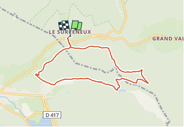
Trail Walking of 8.1 km to be discovered at Grand Est, Vosges, Ban-sur-Meurthe-Clefcy. This trail is proposed by surceneux.
Description
SURCENEUX IRENEE DUVOID (COL DES CHARBONNIERS) CHEMIN DU MILIEU CASUETTE FEU ETANG BELBRIETTE MONTEE DES BROCHES TRAVERSE JDS SURCENEUX
Positioning
Country:
France
Region :
Grand Est
Department/Province :
Vosges
Municipality :
Ban-sur-Meurthe-Clefcy
Location:
Unknown
Start:(Dec)
Start:(UTM)
347835 ; 5329043 (32U) N.
Comments
Trails nearby


Col de la Schlucht
Walking
Very easy
(1)
Le Valtin,
Grand Est,
Vosges,
France

3.5 km | 5.2 km-effort
1h 17min

Yes


Le Sentier des Roches
Walking
Difficult
(2)
Le Valtin,
Grand Est,
Vosges,
France

20 km | 34 km-effort
7h 43min

Yes


gerardmer - la mauselaine . tête grauvelin . Roche boquet . croix claudé . ha...
Walking
Very easy
(1)
Gérardmer,
Grand Est,
Vosges,
France

11.3 km | 16.2 km-effort
3h 42min

Yes


Lac de Lispach et sentier Dielaine
Walking
Medium
(1)
La Bresse,
Grand Est,
Vosges,
France

9.7 km | 14.9 km-effort
2h 30min

Yes


Les Hirschsteine
Walking
Difficult
(1)
Le Valtin,
Grand Est,
Vosges,
France

16.1 km | 25 km-effort
6h 28min

Yes


La vallée de Belbriette - Ban-sur-Meurthe-Clefcy
Walking
Medium
(2)
Ban-sur-Meurthe-Clefcy,
Grand Est,
Vosges,
France

9.8 km | 12.6 km-effort
2h 30min

Yes


23-08-17 Lac Longemer - Lispach
Walking
Medium
(1)
Xonrupt-Longemer,
Grand Est,
Vosges,
France

7 km | 12.1 km-effort
2h 13min

Yes


raquettes
Snowshoes
Very easy
(1)
Le Valtin,
Grand Est,
Vosges,
France

6.6 km | 9.4 km-effort
3h 8min

No


Lac de Lispach
Walking
Easy
(1)
La Bresse,
Grand Est,
Vosges,
France

2.1 km | 2.4 km-effort
44min

Yes