Trail Walking Saint-Cloud - 2024-01-20_13h03m51_Cirkwi-Berges_de_Seine_et_Bois_de_Boulogne_ - Photo

2024-01-20_13h03m51_Cirkwi-Berges_de_Seine_et_Bois_de_Boulogne_

 jpcccb
jpcccb

User

© OpenStreetMap contributors
Length
Length
12.8 km
Max alt
Max alt
93 m
Uphill gradient
Uphill gradient
169 m
Km-Effort
Km-Effort  
15.2 km
Min alt
Min alt
17 m
Downhill gradient
Downhill gradient
215 m
Boucle
Boucle
No
Creation date :
2024-01-20 12:03:51.743
Updated on :
2024-03-04 17:37:43.656

(0 Reviews)

Walking
Walking
3h27
Difficulty : Difficult

Scan this QR Code to open this trail in the SityTrail application

FREE GPS app for hiking

Logo SityTrail SityTrail

IGN / Geographical institutes

Download SityTrail from the App Store Download SityTrail from Google Play

Logo SityTrail SityTrail World

The world is yours!

Download SityTrail from the App Store Download SityTrail from Google Play Download SityTrail on Huawei AppGallery

About

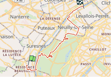
Trail Walking of 12.8 km to be discovered at Ile-de-France, Hauts-de-Seine, Saint-Cloud. This trail is proposed by jpcccb.

Description

Découvrez l'île de la Grande-Jatte, le bois de Boulogne et les berges de la Seine.  Randonnée Labellisée TopoGuide Hauts-de-Seine balade No 6

Elevation profile

Positioning

Country:
France
Region :
Ile-de-France
Department/Province :
Hauts-de-Seine
Municipality :
Saint-Cloud
Location:
Unknown
Start:(UTM)
442545 ; 5411795 (31U) N.

Trails nearby

Trail Walking Rueil-Malmaison - St Germain en Laye - Rueil Malmaison 28 km Inversee - Photo
Walking
GUIDE
chessyca

Walking

Easy
(1)
Rueil-Malmaison, Ile-de-France, Hauts-de-Seine, France
28 km | 32 km-effort
6h 0min
No
Trail Walking Chaville - GRP CV-IDF 20R Chaville à Vaucresson - Photo
Walking
clalaur

Walking

Medium
(1)
Chaville, Ile-de-France, Hauts-de-Seine, France
8.2 km | 11.1 km-effort
2h 30min
No
Trail Walking Paris - DP75-11 De Boulainvilliers à pont du Garigliano - Photo
Walking
clalaur

Walking

Easy
(1)
Paris, Ile-de-France, Paris, France
4.7 km | 5.4 km-effort
1h 13min
No
Trail Walking Paris - DP75-19 de Porte-Maillot à Europe - Photo
Walking
clalaur

Walking

Easy
(1)
Paris, Ile-de-France, Paris, France
4.2 km | 4.8 km-effort
1h 5min
No
Trail Cycle Paris - Paris au bord de Seine - Photo
Cycle
aurel911

Cycle

Very easy
(1)
Paris, Ile-de-France, Paris, France
11.4 km | 14.2 km-effort
46min
No
Trail Walking Paris - 75-04-Paris les Ponts 13km-493-55- - Photo
Walking
rvs147

Walking

Easy
(1)
Paris, Ile-de-France, Paris, France
13.1 km | 16.3 km-effort
3h 22min
No
Trail Walking Boulogne-Billancourt - Parc de St Cloud et forêt de Fausses Reposes - Photo
Walking
tracegps

Walking

Medium
(1)
Boulogne-Billancourt, Ile-de-France, Hauts-de-Seine, France
18.2 km | 23 km-effort
4h 30min
No
Trail On foot Boulogne-Billancourt - Boulogne -  Marne la Coquette - Ville d'Avray - Meudon - Photo
On foot
GUIDE
chessyca

On foot

Difficult
Boulogne-Billancourt, Ile-de-France, Hauts-de-Seine, France
29 km | 36 km-effort
8h 9min
No
Trail On foot Rueil-Malmaison - SityTrail - 3850997 - rando-chatou (1) - Photo
On foot
GUIDE
chessyca

On foot

Medium
Rueil-Malmaison, Ile-de-France, Hauts-de-Seine, France
32 km | 37 km-effort
8h 22min
No


Close
My subscriptions