![](/images/other/stat-length.png)
![Trail Villefort - 2024-01-19_23h37m51_grr736-vallee-et-gorges-du-tarn-lozere-aveyron-tarn-2022 - Photo](https://media.geolcdn.com/t/1900/400/ext.pjpeg?maxdim=2&url=https%3A%2F%2Fsecurestorage.geolives.com%2Fsitytour%2Ftrail-bg%2Fdefault.jpg)
2024-01-19_23h37m51_grr736-vallee-et-gorges-du-tarn-lozere-aveyron-tarn-2022
tosan
User
![Length](/images/other/stat-length.png)
Length
309 km
![Max alt](https://static1.geolcdn.com/siteimages/upload/files/1508320355ic_sort_altitude_max_24dp.png)
Max alt
1455 m
![Uphill gradient](https://static1.geolcdn.com/siteimages/upload/files/1508320355ic_sort_den_pos_24dp.png)
Uphill gradient
10662 m
![Km-Effort](/images/other/stat-length.png)
Km-Effort
452 km
![Min alt](https://static1.geolcdn.com/siteimages/upload/files/1508320355ic_sort_altitude_min_24dp.png)
Min alt
144 m
![Downhill gradient](https://static1.geolcdn.com/siteimages/upload/files/1508320355ic_sort_den_neg_24dp.png)
Downhill gradient
11088 m
![Boucle](https://static1.geolcdn.com/siteimages/upload/files/16400158638029165_repeat_loop_refresh_sync_direction_icon.png)
Boucle
No
Creation date :
2024-01-19 22:37:56.035
Updated on :
2024-01-19 22:38:16.072
![Scan this QR Code to open this trail in the SityTrail application](https://capi.geolives.com/qq0zvz2zws4bq2lad0pu/sitytour/trails/3921388/qr.png?size=200)
FREE GPS app for hiking
About
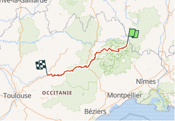
Trail of 309 km to be discovered at Occitania, Lozère, Villefort. This trail is proposed by tosan.
Description
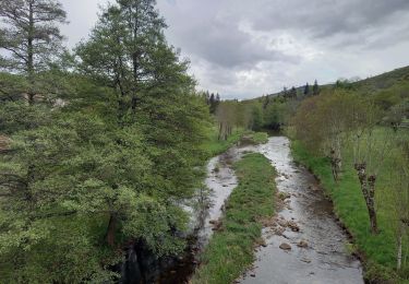
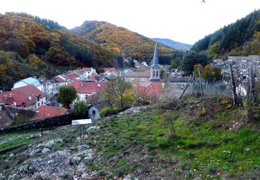
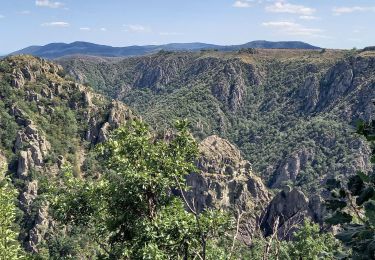
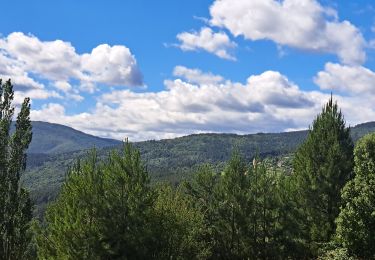
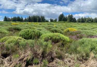
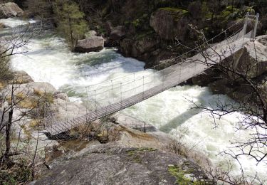
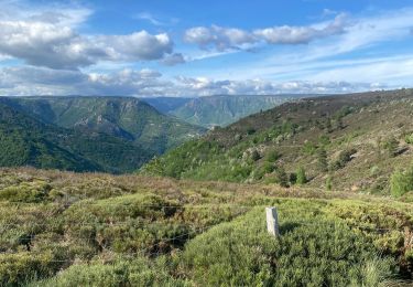
Randonnée sur le GR®736 à travers la Lozère, l'Aveyron et le Tarn le long de la vallée et des Gorges du Tarn de Villefort à Albi. Gîtes d'étapes, Chambres d'hôtes, Maison d'hôtes, Hôtels, Camping, Refuges, Auberges, Commerces.
Positioning
Country:
France
Region :
Occitania
Department/Province :
Lozère
Municipality :
Villefort
Location:
Unknown
Start:(Dec)
Start:(UTM)
574269 ; 4920929 (31T) N.
Comments
Trails nearby
![Trail Walking Pied-de-Borne - GRP Tour du Chassezac en 2 jours - Photo](https://media.geolcdn.com/t/375/260/4939cb41-dd3b-4cb9-aebc-74687e919567.jpg&format=jpg&maxdim=2)
![Walking Walking](https://static1.geolcdn.com/sitytour/trail-icons/101.png)
GRP Tour du Chassezac en 2 jours
Walking
Difficult
Pied-de-Borne,
Occitania,
Lozère,
France
![](/images/other/stat-length.png)
25 km | 36 km-effort
6h 50min
![](https://static1.geolcdn.com/siteimages/upload/files/16400158638029165_repeat_loop_refresh_sync_direction_icon.png)
No
![Trail On foot Malons-et-Elze - GR 44 - Photo](https://media.geolcdn.com/t/375/260/f0c265fe-7de1-43be-8da0-90c630caf3a2.jpeg&format=jpg&maxdim=2)
![On foot On foot](https://static1.geolcdn.com/sitytour/trail-icons/100.png)
![Trail Walking Pourcharesses - au coeur des gorges du chassezac au départ de Villefort - Photo](https://media.geolcdn.com/t/375/260/648a2635-721c-411c-9b65-d15697fb8c14.jpg&format=jpg&maxdim=2)
![Walking Walking](https://static1.geolcdn.com/sitytour/trail-icons/101.png)
au coeur des gorges du chassezac au départ de Villefort
Walking
Difficult
Pourcharesses,
Occitania,
Lozère,
France
![](/images/other/stat-length.png)
17.6 km | 28 km-effort
7h 12min
![](https://static1.geolcdn.com/siteimages/upload/files/16400158638029165_repeat_loop_refresh_sync_direction_icon.png)
Yes
![Trail Walking Ponteils-et-Brésis - Nord haute Vallee de la Cèze - Photo](https://media.geolcdn.com/t/375/260/a0978cc5-8b4f-4e02-8320-6c6f5bf7123f.jpg&format=jpg&maxdim=2)
![Walking Walking](https://static1.geolcdn.com/sitytour/trail-icons/101.png)
Nord haute Vallee de la Cèze
Walking
Difficult
Ponteils-et-Brésis,
Occitania,
Gard,
France
![](/images/other/stat-length.png)
23 km | 34 km-effort
6h 50min
![](https://static1.geolcdn.com/siteimages/upload/files/16400158638029165_repeat_loop_refresh_sync_direction_icon.png)
Yes
![Trail Walking Ponteils-et-Brésis - Bour a es - Photo](https://media.geolcdn.com/t/375/260/33860b35-ef26-4087-9dbf-1e7324b8575e.jpg&format=jpg&maxdim=2)
![Walking Walking](https://static1.geolcdn.com/sitytour/trail-icons/101.png)
Bour a es
Walking
Very difficult
Ponteils-et-Brésis,
Occitania,
Gard,
France
![](/images/other/stat-length.png)
24 km | 36 km-effort
7h 37min
![](https://static1.geolcdn.com/siteimages/upload/files/16400158638029165_repeat_loop_refresh_sync_direction_icon.png)
Yes
![Trail Walking Prévenchères - Gorges de Chassezac - Photo](https://media.geolcdn.com/t/375/260/49ddc4e4-e66c-491b-9c51-4f66b0d6413a.jpg&format=jpg&maxdim=2)
![Walking Walking](https://static1.geolcdn.com/sitytour/trail-icons/101.png)
Gorges de Chassezac
Walking
Difficult
Prévenchères,
Occitania,
Lozère,
France
![](/images/other/stat-length.png)
19 km | 30 km-effort
7h 33min
![](https://static1.geolcdn.com/siteimages/upload/files/16400158638029165_repeat_loop_refresh_sync_direction_icon.png)
Yes
![Trail Walking Pied-de-Borne - Le tour du Chassezac - Photo](https://media.geolcdn.com/t/375/260/befb1c71-a310-40db-8e8f-df4d5ec91bd5.jpg&format=jpg&maxdim=2)
![Walking Walking](https://static1.geolcdn.com/sitytour/trail-icons/101.png)
Le tour du Chassezac
Walking
Very difficult
Pied-de-Borne,
Occitania,
Lozère,
France
![](/images/other/stat-length.png)
49 km | 72 km-effort
37h 28min
![](https://static1.geolcdn.com/siteimages/upload/files/16400158638029165_repeat_loop_refresh_sync_direction_icon.png)
Yes
![Trail Walking Pied-de-Borne - Le tour du chassezac - Photo](https://media.geolcdn.com/t/375/260/34d1863b-5946-4591-908e-d59df5d48945.jpg&format=jpg&maxdim=2)
![Walking Walking](https://static1.geolcdn.com/sitytour/trail-icons/101.png)
Le tour du chassezac
Walking
Very difficult
Pied-de-Borne,
Occitania,
Lozère,
France
![](/images/other/stat-length.png)
49 km | 72 km-effort
16h 34min
![](https://static1.geolcdn.com/siteimages/upload/files/16400158638029165_repeat_loop_refresh_sync_direction_icon.png)
Yes
![Trail Walking Prévenchères - La garde guerin - Photo](https://media.geolcdn.com/t/375/260/f4d5d102-7541-4721-bc49-35572d8c8339.jpg&format=jpg&maxdim=2)
![Walking Walking](https://static1.geolcdn.com/sitytour/trail-icons/101.png)
La garde guerin
Walking
Very easy
Prévenchères,
Occitania,
Lozère,
France
![](/images/other/stat-length.png)
6.1 km | 7.4 km-effort
1h 39min
![](https://static1.geolcdn.com/siteimages/upload/files/16400158638029165_repeat_loop_refresh_sync_direction_icon.png)
Yes