![](/images/other/stat-length.png)
![Trail Walking Leyr - Leyr 15 000m +432m - Photo](https://media.geolcdn.com/t/1900/400/ext.pjpeg?maxdim=2&url=https%3A%2F%2Fstatic1.geolcdn.com%2Fsiteimages%2Fupload%2Ffiles%2F1553511878bg_sport_marche.png)
Leyr 15 000m +432m
DanielROLLET
User
![Length](/images/other/stat-length.png)
![Max alt](https://static1.geolcdn.com/siteimages/upload/files/1508320355ic_sort_altitude_max_24dp.png)
![Uphill gradient](https://static1.geolcdn.com/siteimages/upload/files/1508320355ic_sort_den_pos_24dp.png)
![Km-Effort](/images/other/stat-length.png)
![Min alt](https://static1.geolcdn.com/siteimages/upload/files/1508320355ic_sort_altitude_min_24dp.png)
![Downhill gradient](https://static1.geolcdn.com/siteimages/upload/files/1508320355ic_sort_den_neg_24dp.png)
![Boucle](https://static1.geolcdn.com/siteimages/upload/files/16400158638029165_repeat_loop_refresh_sync_direction_icon.png)
![Walking](https://static1.geolcdn.com/sitytour/trail-icons/101.png)
4h42
Difficulty : Very difficult
![Scan this QR Code to open this trail in the SityTrail application](https://capi.geolives.com/qq0zvz2zws4bq2lad0pu/sitytour/trails/3917853/qr.png?size=200)
FREE GPS app for hiking
About
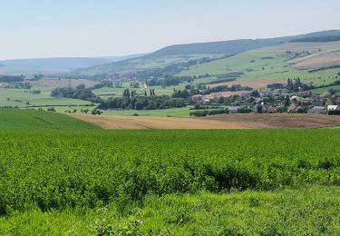
Trail Walking of 15 km to be discovered at Grand Est, Meurthe-et-Moselle, Leyr. This trail is proposed by DanielROLLET.
Description
2024 01 16 - 9h10 à 13h00 -
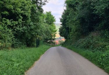
Départ/retour parking face église Leyr
9h10 à 13h00 - Fait quelques raccourcis / au porgramme
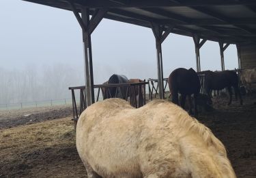
Très beau temps gel -7° - Chemins enneigés (3 à 5cm) qui peuvent cacher par endroits de la glace.
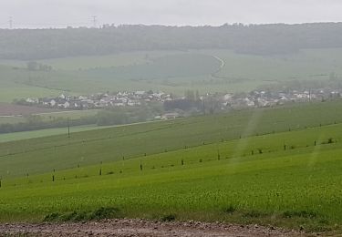
Sinon trés beaux panoramas par endroits
Finale au resto "Villa des Roses" à Dommartin-sous-Amance - A recommander
Positioning
Comments
Trails nearby
![Trail Walking Leyr - LEYR - LE PLATEAU DE LA ROCHETTE - Photo](https://media.geolcdn.com/t/375/260/a23adc35-c5be-4844-8e67-6acd661e64b6.jpg&format=jpg&maxdim=2)
![Walking Walking](https://static1.geolcdn.com/sitytour/trail-icons/101.png)
Walking
![](/images/other/stat-length.png)
![](https://static1.geolcdn.com/siteimages/upload/files/16400158638029165_repeat_loop_refresh_sync_direction_icon.png)
![Trail Walking Montenoy - MONTENOY - LE COL DE VASSUCHAMP - Photo](https://media.geolcdn.com/t/375/260/1b7346bf-b740-4cc9-8679-e8b003a9b130.jpg&format=jpg&maxdim=2)
![Walking Walking](https://static1.geolcdn.com/sitytour/trail-icons/101.png)
Walking
![](/images/other/stat-length.png)
![](https://static1.geolcdn.com/siteimages/upload/files/16400158638029165_repeat_loop_refresh_sync_direction_icon.png)
![Trail Walking Bouxières-aux-Chênes - tour crany 29/5/2019 - Photo](https://media.geolcdn.com/t/375/260/ext.jpg?maxdim=2&url=https%3A%2F%2Fstatic1.geolcdn.com%2Fsiteimages%2Fupload%2Ffiles%2F1553511878bg_sport_marche.png)
![Walking Walking](https://static1.geolcdn.com/sitytour/trail-icons/101.png)
Walking
![](/images/other/stat-length.png)
![](https://static1.geolcdn.com/siteimages/upload/files/16400158638029165_repeat_loop_refresh_sync_direction_icon.png)
![Trail Walking Bouxières-aux-Chênes - Amance blanzey boucles des amance - Photo](https://media.geolcdn.com/t/375/260/682c5f23-15d3-4fdf-8eeb-a74f6e61dda1.jpg&format=jpg&maxdim=2)
![Walking Walking](https://static1.geolcdn.com/sitytour/trail-icons/101.png)
Walking
![](/images/other/stat-length.png)
![](https://static1.geolcdn.com/siteimages/upload/files/16400158638029165_repeat_loop_refresh_sync_direction_icon.png)
![Trail Walking Bouxières-aux-Chênes - bouxieres aux chênes - Blanzey - Photo](https://media.geolcdn.com/t/375/260/53a8e14a-fcca-41b7-ba10-e0d8828d01da.jpg&format=jpg&maxdim=2)
![Walking Walking](https://static1.geolcdn.com/sitytour/trail-icons/101.png)
Walking
![](/images/other/stat-length.png)
![](https://static1.geolcdn.com/siteimages/upload/files/16400158638029165_repeat_loop_refresh_sync_direction_icon.png)
![Trail Walking Bouxières-aux-Chênes - bouxieres aux chênes - la tour de crany - Photo](https://media.geolcdn.com/t/375/260/a86bdc52-4815-4222-8ee6-18cca8f402a0.jpg&format=jpg&maxdim=2)
![Walking Walking](https://static1.geolcdn.com/sitytour/trail-icons/101.png)
Walking
![](/images/other/stat-length.png)
![](https://static1.geolcdn.com/siteimages/upload/files/16400158638029165_repeat_loop_refresh_sync_direction_icon.png)
![Trail On foot Faulx - Circuit L : Variant Faulx - Photo](https://media.geolcdn.com/t/375/260/8edc069d-a9b9-439a-9f46-3e2f5923a387.jpeg&format=jpg&maxdim=2)
![On foot On foot](https://static1.geolcdn.com/sitytour/trail-icons/100.png)
On foot
![](/images/other/stat-length.png)
![](https://static1.geolcdn.com/siteimages/upload/files/16400158638029165_repeat_loop_refresh_sync_direction_icon.png)
![Trail Walking Leyr - Leyr Villers les Moivrons - Photo](https://media.geolcdn.com/t/375/260/1040882a-d0e6-469a-943c-81b69ef5c423.jpg&format=jpg&maxdim=2)
![Walking Walking](https://static1.geolcdn.com/sitytour/trail-icons/101.png)
Walking
![](/images/other/stat-length.png)
![](https://static1.geolcdn.com/siteimages/upload/files/16400158638029165_repeat_loop_refresh_sync_direction_icon.png)
![Trail Walking Leyr - Leyr - plateau de la Rochette - Photo](https://media.geolcdn.com/t/375/260/cb8cc77e-19e0-45de-9c16-527bed2cab64.jpg&format=jpg&maxdim=2)
![Walking Walking](https://static1.geolcdn.com/sitytour/trail-icons/101.png)
Walking
![](/images/other/stat-length.png)
![](https://static1.geolcdn.com/siteimages/upload/files/16400158638029165_repeat_loop_refresh_sync_direction_icon.png)