Trail  Arvieux - 2024-01-11_20h44m13_rspg-villargaudin-le-queyron - Photo

2024-01-11_20h44m13_rspg-villargaudin-le-queyron

 Jack29
Jack29

User

© OpenStreetMap contributors
Length
Length
8.2 km
Max alt
Max alt
1983 m
Uphill gradient
Uphill gradient
408 m
Km-Effort
Km-Effort  
13.6 km
Min alt
Min alt
1597 m
Downhill gradient
Downhill gradient
400 m
Boucle
Boucle
Yes
Creation date :
2024-01-11 19:44:14.232
Updated on :
2024-01-11 19:44:16.207

(1 Reviews)


Scan this QR Code to open this trail in the SityTrail application

FREE GPS app for hiking

Logo SityTrail SityTrail

IGN / Geographical institutes

Download SityTrail from the App Store Download SityTrail from Google Play

Logo SityTrail SityTrail World

The world is yours!

Download SityTrail from the App Store Download SityTrail from Google Play Download SityTrail on Huawei AppGallery

About

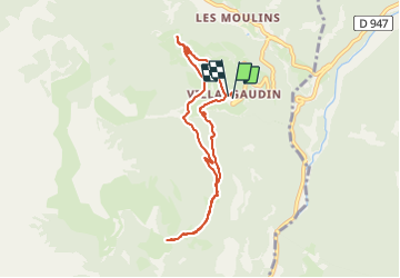
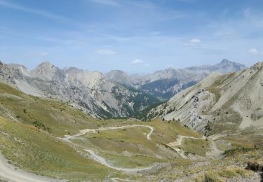
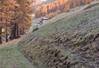
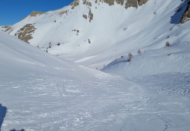
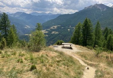
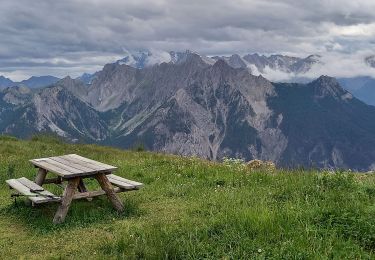
Trail of 8.2 km to be discovered at Provence-Alpes-Côte d'Azur, Hautes-Alpes, Arvieux. This trail is proposed by Jack29.

Description

Au départ du Hameau de Villargaudin, prendre le chemin qui monte vers le Plateau du Queyron puis redescendre vers Villargaudin par le sentier dans la forêt.

Elevation profile

Positioning

Country:
France
Region :
Provence-Alpes-Côte d'Azur
Department/Province :
Hautes-Alpes
Municipality :
Arvieux
Location:
Unknown
Start:(UTM)
322467 ; 4957006 (32T) N.

Comments

Please log in to post a review or rate the element


Trails nearby

Trail Mountain bike Château-Ville-Vieille - Tour du Queyras - Photo
Mountain bike
tracegps

Mountain bike

Very difficult
(1)
Château-Ville-Vieille, Provence-Alpes-Côte d'Azur, Hautes-Alpes, France
32 km | 50 km-effort
3h 0min
Yes
Trail Walking Arvieux - les alpages de Furfande - Photo
Walking
GUIDE
amiral13

Walking

Easy
Arvieux, Provence-Alpes-Côte d'Azur, Hautes-Alpes, France
17 km | 29 km-effort
6h 57min
Yes
Trail Snowshoes Arvieux - Arvieux- Col de Furfande - Photo
Snowshoes
meunier.ph.

Snowshoes

Easy
Arvieux, Provence-Alpes-Côte d'Azur, Hautes-Alpes, France
12.9 km | 26 km-effort
4h 6min
Yes
Trail Walking Arvieux - Lac de Roue variante  - Photo
Walking
rochedaniel

Walking

Difficult
Arvieux, Provence-Alpes-Côte d'Azur, Hautes-Alpes, France
9.5 km | 14.6 km-effort
3h 34min
Yes
Trail Walking Arvieux - arvieux en boucle par furfande ( col et chalets) - Photo
Walking
tchoua

Walking

Easy
Arvieux, Provence-Alpes-Côte d'Azur, Hautes-Alpes, France
21 km | 38 km-effort
4h 40min
Yes
Trail Walking Château-Ville-Vieille - 05-pointe-du-Rasis-13km-760m-aout21 - Photo
Walking
SyMA

Walking

Difficult
Château-Ville-Vieille, Provence-Alpes-Côte d'Azur, Hautes-Alpes, France
13.2 km | 23 km-effort
5h 32min
Yes
Trail Walking Arvieux - Furfande - Photo
Walking
CAUBERTGENEVIEVE

Walking

Medium
Arvieux, Provence-Alpes-Côte d'Azur, Hautes-Alpes, France
12.6 km | 22 km-effort
7h 14min
No
Trail Snowshoes Arvieux - villardgaudin - Photo
Snowshoes
doumeherve

Snowshoes

Very easy
Arvieux, Provence-Alpes-Côte d'Azur, Hautes-Alpes, France
4.7 km | 7.8 km-effort
1h 37min
No
Trail Walking Arvieux - Com de Fontouse - Photo
Walking
Sorriaux

Walking

Difficult
Arvieux, Provence-Alpes-Côte d'Azur, Hautes-Alpes, France
8.6 km | 18.6 km-effort
3h 26min
Yes


Close
My subscriptions