![](/images/other/stat-length.png)
![Trail Walking Isola - Pas de Ste Anne Hiver - Photo](https://media.geolcdn.com/t/1900/400/11df40ab-3e6f-49e5-8a21-6a9fb61d52d5.jpg&format=pjpeg&maxdim=2)
Pas de Ste Anne Hiver
bozo1970
User
![Length](/images/other/stat-length.png)
Length
6.8 km
![Max alt](https://static1.geolcdn.com/siteimages/upload/files/1508320355ic_sort_altitude_max_24dp.png)
Max alt
2291 m
![Uphill gradient](https://static1.geolcdn.com/siteimages/upload/files/1508320355ic_sort_den_pos_24dp.png)
Uphill gradient
625 m
![Km-Effort](/images/other/stat-length.png)
Km-Effort
15.1 km
![Min alt](https://static1.geolcdn.com/siteimages/upload/files/1508320355ic_sort_altitude_min_24dp.png)
Min alt
1655 m
![Downhill gradient](https://static1.geolcdn.com/siteimages/upload/files/1508320355ic_sort_den_neg_24dp.png)
Downhill gradient
628 m
![Boucle](https://static1.geolcdn.com/siteimages/upload/files/16400158638029165_repeat_loop_refresh_sync_direction_icon.png)
Boucle
Yes
Creation date :
2024-01-01 09:38:39.0
Updated on :
2024-01-02 07:06:08.967
![Walking](https://static1.geolcdn.com/sitytour/trail-icons/101.png)
3h07
Difficulty : Medium
![Scan this QR Code to open this trail in the SityTrail application](https://capi.geolives.com/qq0zvz2zws4bq2lad0pu/sitytour/trails/3905681/qr.png?size=200)
FREE GPS app for hiking
About
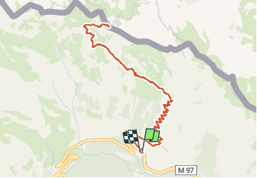
Trail Walking of 6.8 km to be discovered at Provence-Alpes-Côte d'Azur, Maritime Alps, Isola. This trail is proposed by bozo1970.
Description
Montée depuis la route à l'oratoire Ste Anne
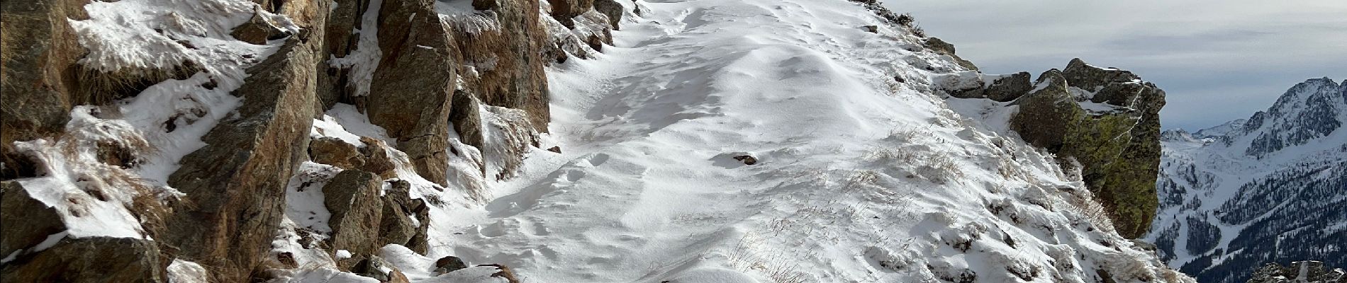
neige tombée la veille 5cm en bas
Pas de Ste Anne en 1h45'
15cm de neige en haut
Chamois
Toujours aussi grandiose surtout avec la neige
Positioning
Country:
France
Region :
Provence-Alpes-Côte d'Azur
Department/Province :
Maritime Alps
Municipality :
Isola
Location:
Unknown
Start:(Dec)
Start:(UTM)
348859 ; 4896778 (32T) N.
Comments
Trails nearby
![Trail Walking Isola - Châtaigneraie ISOLA - Photo](https://media.geolcdn.com/t/375/260/ext.jpg?maxdim=2&url=https%3A%2F%2Fservices.sitytrail.com%2FGeolivesWS%2FDownloadMedia.ashx%3FTrailID%3D470503%26Media%3D20150910120215.jpg)
![Walking Walking](https://static1.geolcdn.com/sitytour/trail-icons/101.png)
Châtaigneraie ISOLA
Walking
Very easy
(1)
Isola,
Provence-Alpes-Côte d'Azur,
Maritime Alps,
France
![](/images/other/stat-length.png)
4.4 km | 7.1 km-effort
2h 9min
![](https://static1.geolcdn.com/siteimages/upload/files/16400158638029165_repeat_loop_refresh_sync_direction_icon.png)
Yes
![Trail Other activity Isola - Isola 2000 baisse Druos refuge Quesa - Photo](https://media.geolcdn.com/t/375/260/ext.jpg?maxdim=2&url=https%3A%2F%2Fservices.sitytrail.com%2FGeolivesWS%2FDownloadMedia.ashx%3FTrailID%3D631831%26Media%3Dfix__20160806152443.jpg)
![Other activity Other activity](https://static1.geolcdn.com/sitytour/trail-icons/900.png)
Isola 2000 baisse Druos refuge Quesa
Other activity
Very easy
(1)
Isola,
Provence-Alpes-Côte d'Azur,
Maritime Alps,
France
![](/images/other/stat-length.png)
21 km | 35 km-effort
8h 5min
![](https://static1.geolcdn.com/siteimages/upload/files/16400158638029165_repeat_loop_refresh_sync_direction_icon.png)
Yes
![Trail Walking Isola - Tête Mercière et Lacs de terre rouge 24.8.24 - Photo](https://media.geolcdn.com/t/375/260/3e3a1aaf-e381-4ca9-a18c-df28b1091979.jpg&format=jpg&maxdim=2)
![Walking Walking](https://static1.geolcdn.com/sitytour/trail-icons/101.png)
Tête Mercière et Lacs de terre rouge 24.8.24
Walking
Medium
Isola,
Provence-Alpes-Côte d'Azur,
Maritime Alps,
France
![](/images/other/stat-length.png)
11.6 km | 18 km-effort
4h 0min
![](https://static1.geolcdn.com/siteimages/upload/files/16400158638029165_repeat_loop_refresh_sync_direction_icon.png)
No
![Trail On foot Isola - Tête Mercière - Photo](https://media.geolcdn.com/t/375/260/8e1ca2e5-a446-45a1-b4b9-1747f6caafe0.jpeg&format=jpg&maxdim=2)
![On foot On foot](https://static1.geolcdn.com/sitytour/trail-icons/100.png)
Tête Mercière
On foot
Easy
Isola,
Provence-Alpes-Côte d'Azur,
Maritime Alps,
France
![](/images/other/stat-length.png)
8.1 km | 14.8 km-effort
3h 21min
![](https://static1.geolcdn.com/siteimages/upload/files/16400158638029165_repeat_loop_refresh_sync_direction_icon.png)
No
![Trail On foot Vinadio - Tour du Lausfer - Photo](https://media.geolcdn.com/t/375/260/cc4c2b4d-e173-4a84-be7d-4686c9701dd6.jpeg&format=jpg&maxdim=2)
![On foot On foot](https://static1.geolcdn.com/sitytour/trail-icons/100.png)
![Trail On foot Vinadio - (SI E13) Sant'Anna di Vinadio - Vinadio Frazione Strepeis - Photo](https://media.geolcdn.com/t/375/260/2964e30b-263b-42c3-aa1c-ecaafebd0df1.jpeg&format=jpg&maxdim=2)
![On foot On foot](https://static1.geolcdn.com/sitytour/trail-icons/100.png)
(SI E13) Sant'Anna di Vinadio - Vinadio Frazione Strepeis
On foot
Easy
Vinadio,
Piemont,
Cuneo,
Italy
![](/images/other/stat-length.png)
9.1 km | 16.1 km-effort
3h 40min
![](https://static1.geolcdn.com/siteimages/upload/files/16400158638029165_repeat_loop_refresh_sync_direction_icon.png)
No
![Trail Walking Isola - cime de la lombarde - Photo](https://media.geolcdn.com/t/375/260/ext.jpg?maxdim=2&url=https%3A%2F%2Fstatic1.geolcdn.com%2Fsiteimages%2Fupload%2Ffiles%2F1553511878bg_sport_marche.png)
![Walking Walking](https://static1.geolcdn.com/sitytour/trail-icons/101.png)
cime de la lombarde
Walking
Very difficult
(1)
Isola,
Provence-Alpes-Côte d'Azur,
Maritime Alps,
France
![](/images/other/stat-length.png)
16.7 km | 31 km-effort
9h 25min
![](https://static1.geolcdn.com/siteimages/upload/files/16400158638029165_repeat_loop_refresh_sync_direction_icon.png)
Yes
![Trail Walking Vinadio - Cime de la Lombarde 2800m 26.8.24 - Photo](https://media.geolcdn.com/t/375/260/a90fbc15-b832-4be5-b4ba-c6dcb34efb02.jpg&format=jpg&maxdim=2)
![Walking Walking](https://static1.geolcdn.com/sitytour/trail-icons/101.png)
Cime de la Lombarde 2800m 26.8.24
Walking
Very difficult
Vinadio,
Piemont,
Cuneo,
Italy
![](/images/other/stat-length.png)
3.4 km | 9.1 km-effort
2h 30min
![](https://static1.geolcdn.com/siteimages/upload/files/16400158638029165_repeat_loop_refresh_sync_direction_icon.png)
Yes
![Trail Walking Vinadio - Tour du Lausfer 25.8.24 - Photo](https://media.geolcdn.com/t/375/260/72863bea-5e16-4036-8653-9180a45481ca.jpg&format=jpg&maxdim=2)
![Walking Walking](https://static1.geolcdn.com/sitytour/trail-icons/101.png)
Tour du Lausfer 25.8.24
Walking
Medium
Vinadio,
Piemont,
Cuneo,
Italy
![](/images/other/stat-length.png)
9 km | 16.2 km-effort
3h 30min
![](https://static1.geolcdn.com/siteimages/upload/files/16400158638029165_repeat_loop_refresh_sync_direction_icon.png)
Yes