![](/images/other/stat-length.png)
![Trail Rilhac-Rancon - Promenade dans Rilhac Rancon - Photo](https://media.geolcdn.com/t/1900/400/ext.pjpeg?maxdim=2&url=https%3A%2F%2Fsecurestorage.geolives.com%2Fsitytour%2Ftrail-bg%2Fdefault.jpg)
Promenade dans Rilhac Rancon
Jean Laversanne
User
![Length](/images/other/stat-length.png)
Length
2.9 km
![Max alt](https://static1.geolcdn.com/siteimages/upload/files/1508320355ic_sort_altitude_max_24dp.png)
Max alt
332 m
![Uphill gradient](https://static1.geolcdn.com/siteimages/upload/files/1508320355ic_sort_den_pos_24dp.png)
Uphill gradient
32 m
![Km-Effort](/images/other/stat-length.png)
Km-Effort
3.4 km
![Min alt](https://static1.geolcdn.com/siteimages/upload/files/1508320355ic_sort_altitude_min_24dp.png)
Min alt
306 m
![Downhill gradient](https://static1.geolcdn.com/siteimages/upload/files/1508320355ic_sort_den_neg_24dp.png)
Downhill gradient
31 m
![Boucle](https://static1.geolcdn.com/siteimages/upload/files/16400158638029165_repeat_loop_refresh_sync_direction_icon.png)
Boucle
Yes
Creation date :
2023-12-31 16:20:09.0
Updated on :
2023-12-31 18:19:05.705
![Scan this QR Code to open this trail in the SityTrail application](https://capi.geolives.com/qq0zvz2zws4bq2lad0pu/sitytour/trails/3905403/qr.png?size=200)
FREE GPS app for hiking
About
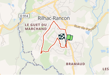
Trail of 2.9 km to be discovered at New Aquitaine, Haute-Vienne, Rilhac-Rancon. This trail is proposed by Jean Laversanne.
Description
De nombreux chemins pédestres serpentent entre les maisons des lotissements permettant de faire une petite promenade bien agréable. Il y a de multiples variantes certains passages entre les maisons ne sont pas sur la carte.
Positioning
Country:
France
Region :
New Aquitaine
Department/Province :
Haute-Vienne
Municipality :
Rilhac-Rancon
Location:
Unknown
Start:(Dec)
Start:(UTM)
369612 ; 5083495 (31T) N.
Comments
Trails nearby
![Trail Mountain bike Chaptelat - Circuit St Eloi - Chaptelat - Photo](https://media.geolcdn.com/t/375/260/ext.jpg?maxdim=2&url=https%3A%2F%2Fservices.sitytrail.com%2FGeolivesWS%2FDownloadMedia.ashx%3FTrailID%3D105844%26Media%3D9813_5.jpg)
![Mountain bike Mountain bike](https://static1.geolcdn.com/sitytour/trail-icons/202.png)
Circuit St Eloi - Chaptelat
Mountain bike
Medium
(1)
Chaptelat,
New Aquitaine,
Haute-Vienne,
France
![](/images/other/stat-length.png)
26 km | 31 km-effort
1h 45min
![](https://static1.geolcdn.com/siteimages/upload/files/16400158638029165_repeat_loop_refresh_sync_direction_icon.png)
Yes
![Trail On foot Rilhac-Rancon - De Rilhac à Payaud et Bramaud - Photo](https://media.geolcdn.com/t/375/260/3e4d29ef-d190-4d96-9eab-7092d1dfb9b0.jpeg&format=jpg&maxdim=2)
![On foot On foot](https://static1.geolcdn.com/sitytour/trail-icons/100.png)
De Rilhac à Payaud et Bramaud
On foot
Easy
Rilhac-Rancon,
New Aquitaine,
Haute-Vienne,
France
![](/images/other/stat-length.png)
4.9 km | 6.3 km-effort
1h 25min
![](https://static1.geolcdn.com/siteimages/upload/files/16400158638029165_repeat_loop_refresh_sync_direction_icon.png)
Yes
![Trail Mountain bike Rilhac-Rancon - De Cassepierre à Nieul - Rilhac Rancon - Photo](https://media.geolcdn.com/t/375/260/ext.jpg?maxdim=2&url=https%3A%2F%2Fservices.sitytrail.com%2FGeolivesWS%2FDownloadMedia.ashx%3FTrailID%3D215191%26Media%3D15796_1.jpg)
![Mountain bike Mountain bike](https://static1.geolcdn.com/sitytour/trail-icons/202.png)
De Cassepierre à Nieul - Rilhac Rancon
Mountain bike
Medium
Rilhac-Rancon,
New Aquitaine,
Haute-Vienne,
France
![](/images/other/stat-length.png)
60 km | 72 km-effort
4h 0min
![](https://static1.geolcdn.com/siteimages/upload/files/16400158638029165_repeat_loop_refresh_sync_direction_icon.png)
Yes
![Trail Mountain bike Chaptelat - Le sentier de Saint Éloi - Chaptelat - Photo](https://media.geolcdn.com/t/375/260/ext.jpg?maxdim=2&url=https%3A%2F%2Fservices.sitytrail.com%2FGeolivesWS%2FDownloadMedia.ashx%3FTrailID%3D110466%26Media%3D5975_2.jpg)
![Mountain bike Mountain bike](https://static1.geolcdn.com/sitytour/trail-icons/202.png)
Le sentier de Saint Éloi - Chaptelat
Mountain bike
Difficult
Chaptelat,
New Aquitaine,
Haute-Vienne,
France
![](/images/other/stat-length.png)
26 km | 31 km-effort
2h 30min
![](https://static1.geolcdn.com/siteimages/upload/files/16400158638029165_repeat_loop_refresh_sync_direction_icon.png)
Yes
![Trail Walking Chaptelat - Le sentier de Saint Éloi - Chaptelat - Photo](https://media.geolcdn.com/t/375/260/ext.jpg?maxdim=2&url=https%3A%2F%2Fservices.sitytrail.com%2FGeolivesWS%2FDownloadMedia.ashx%3FTrailID%3D110465%26Media%3D5975_2.jpg)
![Walking Walking](https://static1.geolcdn.com/sitytour/trail-icons/101.png)
Le sentier de Saint Éloi - Chaptelat
Walking
Difficult
Chaptelat,
New Aquitaine,
Haute-Vienne,
France
![](/images/other/stat-length.png)
26 km | 31 km-effort
6h 0min
![](https://static1.geolcdn.com/siteimages/upload/files/16400158638029165_repeat_loop_refresh_sync_direction_icon.png)
Yes
![Trail Mountain bike Chaptelat - Chateau de Nieul - Chaptelat - Photo](https://media.geolcdn.com/t/375/260/ext.jpg?maxdim=2&url=https%3A%2F%2Fservices.sitytrail.com%2FGeolivesWS%2FDownloadMedia.ashx%3FTrailID%3D105812%26Media%3D9735_1.jpg)
![Mountain bike Mountain bike](https://static1.geolcdn.com/sitytour/trail-icons/202.png)
Chateau de Nieul - Chaptelat
Mountain bike
Difficult
(1)
Chaptelat,
New Aquitaine,
Haute-Vienne,
France
![](/images/other/stat-length.png)
38 km | 46 km-effort
2h 40min
![](https://static1.geolcdn.com/siteimages/upload/files/16400158638029165_repeat_loop_refresh_sync_direction_icon.png)
Yes
![Trail Walking Limoges - tour uzurat - Photo](https://media.geolcdn.com/t/375/260/ext.jpg?maxdim=2&url=https%3A%2F%2Fstatic1.geolcdn.com%2Fsiteimages%2Fupload%2Ffiles%2F1553511878bg_sport_marche.png)
![Walking Walking](https://static1.geolcdn.com/sitytour/trail-icons/101.png)
tour uzurat
Walking
Easy
Limoges,
New Aquitaine,
Haute-Vienne,
France
![](/images/other/stat-length.png)
4.4 km | 5.3 km-effort
53min
![](https://static1.geolcdn.com/siteimages/upload/files/16400158638029165_repeat_loop_refresh_sync_direction_icon.png)
No
![Trail Walking Limoges - La Mazelle_08-05-23_traces - Photo](https://media.geolcdn.com/t/375/260/ext.jpg?maxdim=2&url=https%3A%2F%2Fstatic1.geolcdn.com%2Fsiteimages%2Fupload%2Ffiles%2F1553511878bg_sport_marche.png)
![Walking Walking](https://static1.geolcdn.com/sitytour/trail-icons/101.png)
La Mazelle_08-05-23_traces
Walking
Medium
Limoges,
New Aquitaine,
Haute-Vienne,
France
![](/images/other/stat-length.png)
9.6 km | 11.3 km-effort
2h 33min
![](https://static1.geolcdn.com/siteimages/upload/files/16400158638029165_repeat_loop_refresh_sync_direction_icon.png)
Yes
![Trail Car Chaptelat - aurieras - Photo](https://media.geolcdn.com/t/375/260/ext.jpg?maxdim=2&url=https%3A%2F%2Fstatic1.geolcdn.com%2Fsiteimages%2Fupload%2Ffiles%2F15247431544x4.jpg)
![Car Car](https://static1.geolcdn.com/sitytour/trail-icons/401.png)