Trail Walking Azé - m'ont pele - Photo
 gcournac
gcournac

User

© OpenStreetMap contributors
Length
Length
5.9 km
Max alt
Max alt
412 m
Uphill gradient
Uphill gradient
194 m
Km-Effort
Km-Effort  
8.5 km
Min alt
Min alt
270 m
Downhill gradient
Downhill gradient
196 m
Boucle
Boucle
Yes
Creation date :
2023-12-30 08:15:54.872
Updated on :
2023-12-30 10:00:52.339

(0 Reviews)

Walking
Walking
1h11
Difficulty : Medium

Scan this QR Code to open this trail in the SityTrail application

FREE GPS app for hiking

Logo SityTrail SityTrail

IGN / Geographical institutes

Download SityTrail from the App Store Download SityTrail from Google Play

Logo SityTrail SityTrail World

The world is yours!

Download SityTrail from the App Store Download SityTrail from Google Play Download SityTrail on Huawei AppGallery

About

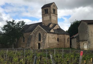
Trail Walking of 5.9 km to be discovered at Bourgogne-Franche-Comté, Saône-et-Loire, Azé. This trail is proposed by gcournac.

Description

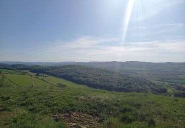
belle rando joli tour du mont pelé.

Elevation profile

Positioning

Country:
France
Region :
Bourgogne-Franche-Comté
Department/Province :
Saône-et-Loire
Municipality :
Azé
Location:
Unknown
Start:(UTM)
633309 ; 5143026 (31T) N.

Trails nearby

Trail Walking Donzy-le-Pertuis - Donzy le Perthuis la fontaine des croix page 66 - Photo
Walking
grasgilbert

Walking

Very difficult
(3)
Donzy-le-Pertuis, Bourgogne-Franche-Comté, Saône-et-Loire, France
16.8 km | 23 km-effort
5h 18min
Yes
Trail Walking Saint-Gengoux-de-Scissé - Saint Gengoux de scisse le Mont St Romain page 146 - Photo
Walking
grasgilbert

Walking

Difficult
(1)
Saint-Gengoux-de-Scissé, Bourgogne-Franche-Comté, Saône-et-Loire, France
18.2 km | 26 km-effort
5h 38min
Yes
Trail Walking Verzé - La Croix montmain verze - Photo
Walking
darrisa

Walking

Difficult
Verzé, Bourgogne-Franche-Comté, Saône-et-Loire, France
9 km | 12.4 km-effort
4h 14min
Yes
Trail Walking Igé - Le Mont de Mandé  - Photo
Walking
darrisa

Walking

Medium
Igé, Bourgogne-Franche-Comté, Saône-et-Loire, France
4.8 km | 7.1 km-effort
2h 50min
Yes
Trail Walking Igé - IGÉ (16 km - D. 420 m) - Photo
Walking
Thomasdanielle

Walking

Medium
(1)
Igé, Bourgogne-Franche-Comté, Saône-et-Loire, France
16.1 km | 22 km-effort
4h 54min
Yes
Trail Walking Donzy-le-Pertuis - autour de Donzy - Photo
Walking
margotjl

Walking

Medium
Donzy-le-Pertuis, Bourgogne-Franche-Comté, Saône-et-Loire, France
17.1 km | 23 km-effort
6h 17min
Yes
Trail Walking Saint-Maurice-de-Satonnay - laizé st maurice - Photo
Walking
philippe nicolai

Walking

Medium
(1)
Saint-Maurice-de-Satonnay, Bourgogne-Franche-Comté, Saône-et-Loire, France
6.9 km | 7.8 km-effort
1h 53min
Yes
Trail Horseback riding Berzé-le-Châtel - samedi 10 octobre 2020 de 9h00/18h30 pèlerinage équestre  LE CURÉ DE CHAPAIZE Berzé-le-Châtel /Chapaize
Horseback riding
lagrange71

Horseback riding

Difficult
Berzé-le-Châtel, Bourgogne-Franche-Comté, Saône-et-Loire, France
33 km | 42 km-effort
5h 12min
No
Trail Walking Berzé-le-Châtel - Berzé le Chatel - Photo
Walking
Bcomb

Walking

Difficult
Berzé-le-Châtel, Bourgogne-Franche-Comté, Saône-et-Loire, France
11 km | 14.5 km-effort
3h 16min
Yes


Close
My subscriptions