![](/images/other/stat-length.png)
![Trail Walking Marcilly-en-Beauce - Varennes - Photo](https://media.geolcdn.com/t/1900/400/e5fe1065-d10c-4b43-96c8-69a926a5b2c1.jpg&format=pjpeg&maxdim=2)
Varennes
guydu41
User
![Length](/images/other/stat-length.png)
![Max alt](https://static1.geolcdn.com/siteimages/upload/files/1508320355ic_sort_altitude_max_24dp.png)
![Uphill gradient](https://static1.geolcdn.com/siteimages/upload/files/1508320355ic_sort_den_pos_24dp.png)
![Km-Effort](/images/other/stat-length.png)
![Min alt](https://static1.geolcdn.com/siteimages/upload/files/1508320355ic_sort_altitude_min_24dp.png)
![Downhill gradient](https://static1.geolcdn.com/siteimages/upload/files/1508320355ic_sort_den_neg_24dp.png)
![Boucle](https://static1.geolcdn.com/siteimages/upload/files/16400158638029165_repeat_loop_refresh_sync_direction_icon.png)
![Walking](https://static1.geolcdn.com/sitytour/trail-icons/101.png)
2h03
Difficulty : Easy
![Scan this QR Code to open this trail in the SityTrail application](https://capi.geolives.com/qq0zvz2zws4bq2lad0pu/sitytour/trails/3902153/qr.png?size=200)
FREE GPS app for hiking
About
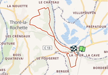
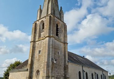
Trail Walking of 7.9 km to be discovered at Centre-Loire Valley, Loir-et-Cher, Marcilly-en-Beauce. This trail is proposed by guydu41.
Description
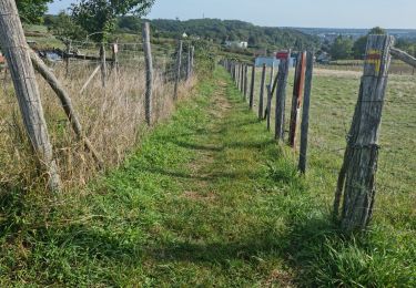
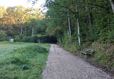
Agréable petit circuit sur des sentiers et chemins à travers bois et champs.
Remarque : Le chemin d'accès au château de Rochambeau est privé mais il peut être emprunté sur quelques dizaines de mètres jusqu'au portail d'entré. A gauche de celui-ci, un sentier longeant plusieurs caves troglodytes monte jusqu'au GRP sur les hauteurs du Val de Loir.
Positioning
Comments
Trails nearby
![Trail On foot Villiers-sur-Loir - Circuit des Côteaux - Photo](https://media.geolcdn.com/t/375/260/25cb373c-e85b-47b3-b4c8-0c4c4213b15c.jpeg&format=jpg&maxdim=2)
![On foot On foot](https://static1.geolcdn.com/sitytour/trail-icons/100.png)
On foot
![](/images/other/stat-length.png)
![](https://static1.geolcdn.com/siteimages/upload/files/16400158638029165_repeat_loop_refresh_sync_direction_icon.png)
![Trail Walking Thoré-la-Rochette - Thoré-la-Rochette - Vallée et Coteaux du Loir - Photo](https://media.geolcdn.com/t/375/260/3f4c80d2-3437-4e69-84de-30a02f464543.jpg&format=jpg&maxdim=2)
![Walking Walking](https://static1.geolcdn.com/sitytour/trail-icons/101.png)
Walking
![](/images/other/stat-length.png)
![](https://static1.geolcdn.com/siteimages/upload/files/16400158638029165_repeat_loop_refresh_sync_direction_icon.png)
![Trail Walking Naveil - Naveil - Photo](https://media.geolcdn.com/t/375/260/37d67a4f-f628-4e03-8093-029fa7b56966.jpg&format=jpg&maxdim=2)
![Walking Walking](https://static1.geolcdn.com/sitytour/trail-icons/101.png)
Walking
![](/images/other/stat-length.png)
![](https://static1.geolcdn.com/siteimages/upload/files/16400158638029165_repeat_loop_refresh_sync_direction_icon.png)
![Trail Walking Mazangé - Bonaventure - Moulin de la Loupe - Photo](https://media.geolcdn.com/t/375/260/759d7924-4ccb-43c3-8104-ebc2f5335c97.jpg&format=jpg&maxdim=2)
![Walking Walking](https://static1.geolcdn.com/sitytour/trail-icons/101.png)
Walking
![](/images/other/stat-length.png)
![](https://static1.geolcdn.com/siteimages/upload/files/16400158638029165_repeat_loop_refresh_sync_direction_icon.png)
![Trail Walking Lunay - Château de la Mézière - Asnières - Photo](https://media.geolcdn.com/t/375/260/7020eb26-114b-4b8b-93d9-05c4bb72eb01.jpg&format=jpg&maxdim=2)
![Walking Walking](https://static1.geolcdn.com/sitytour/trail-icons/101.png)
Walking
![](/images/other/stat-length.png)
![](https://static1.geolcdn.com/siteimages/upload/files/16400158638029165_repeat_loop_refresh_sync_direction_icon.png)
![Trail Walking Houssay - Houssay - Photo](https://media.geolcdn.com/t/375/260/3bd1239e-bd99-41e7-b552-6fe8c8fd81df.jpg&format=jpg&maxdim=2)
![Walking Walking](https://static1.geolcdn.com/sitytour/trail-icons/101.png)
Walking
![](/images/other/stat-length.png)
![](https://static1.geolcdn.com/siteimages/upload/files/16400158638029165_repeat_loop_refresh_sync_direction_icon.png)
![Trail Walking Vendôme - Vendôme - Villiers-sur-Loir - Photo](https://media.geolcdn.com/t/375/260/e66027b3-088b-4b5f-b5f5-ac0b8671fb02.jpg&format=jpg&maxdim=2)
![Walking Walking](https://static1.geolcdn.com/sitytour/trail-icons/101.png)
Walking
![](/images/other/stat-length.png)
![](https://static1.geolcdn.com/siteimages/upload/files/16400158638029165_repeat_loop_refresh_sync_direction_icon.png)
![Trail Walking Vendôme - Vendôme Nord - Photo](https://media.geolcdn.com/t/375/260/8467046a-0d6b-4c3c-968e-b82cf7fdf11f.jpg&format=jpg&maxdim=2)
![Walking Walking](https://static1.geolcdn.com/sitytour/trail-icons/101.png)
Walking
![](/images/other/stat-length.png)
![](https://static1.geolcdn.com/siteimages/upload/files/16400158638029165_repeat_loop_refresh_sync_direction_icon.png)
![Trail Walking Thoré-la-Rochette - Thoré-la-Rochette - Vallée et Coteaux du Loir - Photo](https://media.geolcdn.com/t/375/260/344cfef8-5ffd-42a8-843d-f0a9586064a7.jpg&format=jpg&maxdim=2)
![Walking Walking](https://static1.geolcdn.com/sitytour/trail-icons/101.png)
Walking
![](/images/other/stat-length.png)
![](https://static1.geolcdn.com/siteimages/upload/files/16400158638029165_repeat_loop_refresh_sync_direction_icon.png)