![](/images/other/stat-length.png)
![Trail Walking Catllar - Catlar sentier des cabanes, chapelle Saint Jacques - Photo](https://media.geolcdn.com/t/1900/400/ext.pjpeg?maxdim=2&url=https%3A%2F%2Fstatic1.geolcdn.com%2Fsiteimages%2Fupload%2Ffiles%2F1553511878bg_sport_marche.png)
Catlar sentier des cabanes, chapelle Saint Jacques
suresnois
User
![Length](/images/other/stat-length.png)
![Max alt](https://static1.geolcdn.com/siteimages/upload/files/1508320355ic_sort_altitude_max_24dp.png)
![Uphill gradient](https://static1.geolcdn.com/siteimages/upload/files/1508320355ic_sort_den_pos_24dp.png)
![Km-Effort](/images/other/stat-length.png)
![Min alt](https://static1.geolcdn.com/siteimages/upload/files/1508320355ic_sort_altitude_min_24dp.png)
![Downhill gradient](https://static1.geolcdn.com/siteimages/upload/files/1508320355ic_sort_den_neg_24dp.png)
![Boucle](https://static1.geolcdn.com/siteimages/upload/files/16400158638029165_repeat_loop_refresh_sync_direction_icon.png)
![Walking](https://static1.geolcdn.com/sitytour/trail-icons/101.png)
6h11
Difficulty : Difficult
![Scan this QR Code to open this trail in the SityTrail application](https://capi.geolives.com/qq0zvz2zws4bq2lad0pu/sitytour/trails/3893859/qr.png?size=200)
FREE GPS app for hiking
About
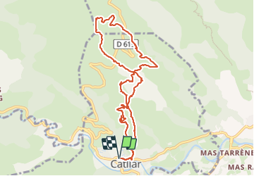
Trail Walking of 11.3 km to be discovered at Occitania, Pyrénées-Orientales, Catllar. This trail is proposed by suresnois.
Description
Se garer près de l'église du village puis prendre la route de st jacques de Calahons, En haut de la côte on prend le sentier et on le continu jusqu'à la bifurcation,
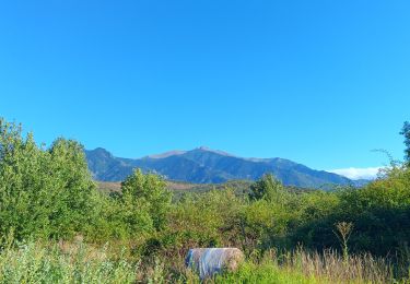
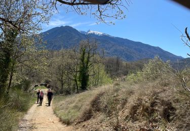
On prend le sentier à droite (trait jaune), Belles vue sur le Canigou et sur la vallée,
Au bout de 2km, on arrive à un carrefour de plusieurs sentier, On prend celui de gauche (sentier des cabanes
500 m plus loin on prend le sentier à gauche,
Après 200m on prend le sentier à droite,
On prend le sentier à gauche, Pendant tout ce trajet on peut voir de nombreux orris qui ont été restaurer,
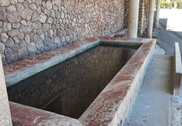
On traverse le DFCI, On prend le petit sentier en face, On arrive à un ensemble de construction en ruine,
Après un petit km on prend le sentier sur la gauche,
Après 500m prendre à droite, vue sur la chapelle Saint Jacques,
On croise de nouveau la piste mais on ne la prend pas on va tout droit,
Au Cortal d'en Raurel on prend le sentier à gauche,
On fait 500m on arrive à un passage canadien on prend à gauche le chemin à peine marqué, qui longe la cloture,
On arrive à un portillon et on prend à gauche direction un semblant de tour, Attention la descente est assez raide et glissante,
Au bout de 500m on prend à gauche puis tout de suite à droite panneau « sentier des cabanes »,
On prend le sentier à gauche,
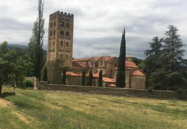
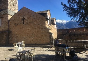
On arrive à la chapelle Saint Jacques de Calahon, qui à été restauré et la garde est assuré par un ermite, A l'intérieur on peut admirer de beaux retables, En sortant de la chapelle on prend le sentier qui la longe, Celui-ci est balisé par des coquilles Saint Jacques,
Au carrefour que l'on a déjà vue, on prend le sentier à gauche qui nous amène à notre point de départ, Attention pendant la descente risque de glisser,
Distance : 11,5 km
Dénivelé ; 530m
Durée : 4h
Pour info :
Si vous partez seul prévenir un proche de votre itinéraire et de la durée,
Chaussures de marche, bâtons, GPS, carte de la randonnée avec l'itinéraire, trousse premiers secours,,
Apportez suffisamment d'eau, des en cas (fruits sec, barres de céréales,,,)
Selon les saisons : bonnet, gants, vêtements chauds, casquette, lunettes de soleil, crème solaire
Positioning
Comments
Trails nearby
![Trail Walking Ria-Sirach - Sirach-Taurinya-Saint Michel de Cuxa - Photo](https://media.geolcdn.com/t/375/260/ext.jpg?maxdim=2&url=https%3A%2F%2Fservices.sitytrail.com%2FGeolivesWS%2FDownloadMedia.ashx%3FTrailID%3D631724%26Media%3D20160916113736.jpg)
![Walking Walking](https://static1.geolcdn.com/sitytour/trail-icons/101.png)
Walking
![](/images/other/stat-length.png)
![](https://static1.geolcdn.com/siteimages/upload/files/16400158638029165_repeat_loop_refresh_sync_direction_icon.png)
![Trail Motor Codalet - Prades - Villefranche de Conflent - Evol - Photo](https://media.geolcdn.com/t/375/260/ext.jpg?maxdim=2&url=https%3A%2F%2Fservices.sitytrail.com%2FGeolivesWS%2FDownloadMedia.ashx%3FTrailID%3D554984%26Media%3D20160417170544.jpg)
![Motor Motor](https://static1.geolcdn.com/sitytour/trail-icons/400.png)
Motor
![](/images/other/stat-length.png)
![](https://static1.geolcdn.com/siteimages/upload/files/16400158638029165_repeat_loop_refresh_sync_direction_icon.png)
![Trail Mountain bike Ria-Sirach - cami del pi - Photo](https://media.geolcdn.com/t/375/260/ext.jpg?maxdim=2&url=https%3A%2F%2Fstatic1.geolcdn.com%2Fsiteimages%2Fupload%2Ffiles%2F1524743154velo.jpg)
![Mountain bike Mountain bike](https://static1.geolcdn.com/sitytour/trail-icons/202.png)
Mountain bike
![](/images/other/stat-length.png)
![](https://static1.geolcdn.com/siteimages/upload/files/16400158638029165_repeat_loop_refresh_sync_direction_icon.png)
![Trail Walking Codalet - le tour de saint Michel de cuxià - Photo](https://media.geolcdn.com/t/375/260/f5bc736e-d2e4-4509-97da-24e2dac475ec.jpg&format=jpg&maxdim=2)
![Walking Walking](https://static1.geolcdn.com/sitytour/trail-icons/101.png)
Walking
![](/images/other/stat-length.png)
![](https://static1.geolcdn.com/siteimages/upload/files/16400158638029165_repeat_loop_refresh_sync_direction_icon.png)
![Trail Walking Codalet - Codalet /Taurinya / St Michel de cuca - Photo](https://media.geolcdn.com/t/375/260/79b1aac1-078d-49c1-b315-5474fef3ade2.jpg&format=jpg&maxdim=2)
![Walking Walking](https://static1.geolcdn.com/sitytour/trail-icons/101.png)
Walking
![](/images/other/stat-length.png)
![](https://static1.geolcdn.com/siteimages/upload/files/16400158638029165_repeat_loop_refresh_sync_direction_icon.png)
![Trail Walking Prades - codalet . coll de Clara . abbaye St Michel de Cuxa . canal bohère - Photo](https://media.geolcdn.com/t/375/260/023829b3-fc10-4f96-8309-5afd712a9504.jpg&format=jpg&maxdim=2)
![Walking Walking](https://static1.geolcdn.com/sitytour/trail-icons/101.png)
Walking
![](/images/other/stat-length.png)
![](https://static1.geolcdn.com/siteimages/upload/files/16400158638029165_repeat_loop_refresh_sync_direction_icon.png)
![Trail Walking Catllar - cap Béarn depuis port vendres - Photo](https://media.geolcdn.com/t/375/260/1195a2cb-99d5-4e1b-bb14-6566bf3b4c2e.jpg&format=jpg&maxdim=2)
![Walking Walking](https://static1.geolcdn.com/sitytour/trail-icons/101.png)
Walking
![](/images/other/stat-length.png)
![](https://static1.geolcdn.com/siteimages/upload/files/16400158638029165_repeat_loop_refresh_sync_direction_icon.png)
![Trail Walking Los Masos - Los Masos Lionat - Photo](https://media.geolcdn.com/t/375/260/125a95df-244e-4de4-8ca5-3e656269ddeb.jpg&format=jpg&maxdim=2)
![Walking Walking](https://static1.geolcdn.com/sitytour/trail-icons/101.png)
Walking
![](/images/other/stat-length.png)
![](https://static1.geolcdn.com/siteimages/upload/files/16400158638029165_repeat_loop_refresh_sync_direction_icon.png)
![Trail Walking Fuilla - Ville franche / fort Liberia /Chapelle St André de Bell lloc / St esteve de calmeilles - Photo](https://media.geolcdn.com/t/375/260/470eeb99-3cac-42f3-a8ba-bdbabe475ec4.jpg&format=jpg&maxdim=2)
![Walking Walking](https://static1.geolcdn.com/sitytour/trail-icons/101.png)
Walking
![](/images/other/stat-length.png)
![](https://static1.geolcdn.com/siteimages/upload/files/16400158638029165_repeat_loop_refresh_sync_direction_icon.png)