![](/images/other/stat-length.png)
![Trail Walking Voeren - Veurbos - Roodbos - Photo](https://media.geolcdn.com/t/1900/400/954e0552-84b3-47cf-9fcc-ecc48bbf6e54.jpg&format=pjpeg&maxdim=2)
Veurbos - Roodbos
mumu.larandonneuse
User GUIDE
![Length](/images/other/stat-length.png)
Length
4.2 km
![Max alt](https://static1.geolcdn.com/siteimages/upload/files/1508320355ic_sort_altitude_max_24dp.png)
Max alt
270 m
![Uphill gradient](https://static1.geolcdn.com/siteimages/upload/files/1508320355ic_sort_den_pos_24dp.png)
Uphill gradient
75 m
![Km-Effort](/images/other/stat-length.png)
Km-Effort
5.2 km
![Min alt](https://static1.geolcdn.com/siteimages/upload/files/1508320355ic_sort_altitude_min_24dp.png)
Min alt
210 m
![Downhill gradient](https://static1.geolcdn.com/siteimages/upload/files/1508320355ic_sort_den_neg_24dp.png)
Downhill gradient
75 m
![Boucle](https://static1.geolcdn.com/siteimages/upload/files/16400158638029165_repeat_loop_refresh_sync_direction_icon.png)
Boucle
Yes
Creation date :
2023-12-13 10:25:57.622
Updated on :
2023-12-13 12:08:13.556
![Walking](https://static1.geolcdn.com/sitytour/trail-icons/101.png)
1h10
Difficulty : Easy
![Scan this QR Code to open this trail in the SityTrail application](https://capi.geolives.com/qq0zvz2zws4bq2lad0pu/sitytour/trails/3891973/qr.png?size=200)
FREE GPS app for hiking
About
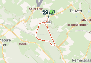
Trail Walking of 4.2 km to be discovered at Flanders, Limburg, Voeren. This trail is proposed by mumu.larandonneuse.
Description
Une petite balade boisée pour récupérer les desserts glacés 🍧de Noël 🎄 🎅 à la ferme 't Voerboertje (distributeur automatique 24h/24).
📍Brasserie Het Rode Bos ( ouvert dès 11h00 et fermé lundi & mardi)
Passage par les points-noeuds 75 74 73.
Positioning
Country:
Belgium
Region :
Flanders
Department/Province :
Limburg
Municipality :
Voeren
Location:
Teuven
Start:(Dec)
Start:(UTM)
701461 ; 5625743 (31U) N.
Comments
Trails nearby
![Trail Walking Plombières - Hombourg. Natura 2000, des sites qui valent le détour ! Lg6 - Photo](https://media.geolcdn.com/t/375/260/ext.jpg?maxdim=2&url=https%3A%2F%2Fservices.sitytrail.com%2FGeolivesWS%2FDownloadMedia.ashx%3FTrailID%3D142693%26Media%3D08dbd372-9409-44af-92fd-51b9576d1e78.JPG)
![Walking Walking](https://static1.geolcdn.com/sitytour/trail-icons/101.png)
Hombourg. Natura 2000, des sites qui valent le détour ! Lg6
Walking
Easy
(10)
Plombières,
Wallonia,
Liège,
Belgium
![](/images/other/stat-length.png)
9.5 km | 12 km-effort
2h 35min
![](https://static1.geolcdn.com/siteimages/upload/files/16400158638029165_repeat_loop_refresh_sync_direction_icon.png)
Yes
![Trail Walking Gulpen-Wittem - 2024-10-26_19h39m19_1518.gpx.xml - Photo](https://media.geolcdn.com/t/375/260/8521698d-6278-4db9-b85e-3d349e5101aa.jpg&format=jpg&maxdim=2)
![Walking Walking](https://static1.geolcdn.com/sitytour/trail-icons/101.png)
2024-10-26_19h39m19_1518.gpx.xml
Walking
Medium
(1)
Gulpen-Wittem,
Limburg,
Unknown,
Netherlands
![](/images/other/stat-length.png)
6.6 km | 8.9 km-effort
2h 0min
![](https://static1.geolcdn.com/siteimages/upload/files/16400158638029165_repeat_loop_refresh_sync_direction_icon.png)
Yes
![Trail Walking Eijsden-Margraten - 2024-07-15_17h32m47_eijsden-margraten-mh1-altenbroek - Photo](https://media.geolcdn.com/t/375/260/1dd6d074-f00f-48cf-a4e6-d95117778ebf.jpg&format=jpg&maxdim=2)
![Walking Walking](https://static1.geolcdn.com/sitytour/trail-icons/101.png)
2024-07-15_17h32m47_eijsden-margraten-mh1-altenbroek
Walking
Medium
(1)
Eijsden-Margraten,
Limburg,
Unknown,
Netherlands
![](/images/other/stat-length.png)
8.8 km | 11 km-effort
2h 29min
![](https://static1.geolcdn.com/siteimages/upload/files/16400158638029165_repeat_loop_refresh_sync_direction_icon.png)
Yes
![Trail Walking Eijsden-Margraten - Mheer - Banholt - Hoogbos - Photo](https://media.geolcdn.com/t/375/260/1f70cdf1-9a0b-4d25-acc7-7c75993bbb86.jpg&format=jpg&maxdim=2)
![Walking Walking](https://static1.geolcdn.com/sitytour/trail-icons/101.png)
Mheer - Banholt - Hoogbos
Walking
Medium
(1)
Eijsden-Margraten,
Limburg,
Unknown,
Netherlands
![](/images/other/stat-length.png)
12.5 km | 14.5 km-effort
3h 4min
![](https://static1.geolcdn.com/siteimages/upload/files/16400158638029165_repeat_loop_refresh_sync_direction_icon.png)
Yes
![Trail Walking Voeren - Amstel Gold Race 2024 🚲 - Photo](https://media.geolcdn.com/t/375/260/bca146f7-0c03-4970-a3ca-ea328283e994.jpg&format=jpg&maxdim=2)
![Walking Walking](https://static1.geolcdn.com/sitytour/trail-icons/101.png)
Amstel Gold Race 2024 🚲
Walking
Medium
(1)
Voeren,
Flanders,
Limburg,
Belgium
![](/images/other/stat-length.png)
11.7 km | 14.9 km-effort
3h 23min
![](https://static1.geolcdn.com/siteimages/upload/files/16400158638029165_repeat_loop_refresh_sync_direction_icon.png)
Yes
![Trail Walking Gulpen-Wittem - Epen - Vijlen - Mechelen - Photo](https://media.geolcdn.com/t/375/260/5bb62a81-94e0-4aeb-8671-819fde7ee6b3.jpg&format=jpg&maxdim=2)
![Walking Walking](https://static1.geolcdn.com/sitytour/trail-icons/101.png)
Epen - Vijlen - Mechelen
Walking
Easy
(1)
Gulpen-Wittem,
Limburg,
Unknown,
Netherlands
![](/images/other/stat-length.png)
13.9 km | 17.5 km-effort
3h 9min
![](https://static1.geolcdn.com/siteimages/upload/files/16400158638029165_repeat_loop_refresh_sync_direction_icon.png)
Yes
![Trail Walking Voeren - Ulvend - La Planck - Noorbeek - Photo](https://media.geolcdn.com/t/375/260/1b8a3af4-c436-4943-b8e2-3197209c6144.jpg&format=jpg&maxdim=2)
![Walking Walking](https://static1.geolcdn.com/sitytour/trail-icons/101.png)
Ulvend - La Planck - Noorbeek
Walking
Easy
(1)
Voeren,
Flanders,
Limburg,
Belgium
![](/images/other/stat-length.png)
17 km | 22 km-effort
4h 57min
![](https://static1.geolcdn.com/siteimages/upload/files/16400158638029165_repeat_loop_refresh_sync_direction_icon.png)
Yes
![Trail Walking Voeren - 2022-11-11_17h35m36_wandelroute-de-voerstreek-mooiste - Photo](https://media.geolcdn.com/t/375/260/3df743f8-88e4-4c10-a47a-c05fdf0072fe.jpg&format=jpg&maxdim=2)
![Walking Walking](https://static1.geolcdn.com/sitytour/trail-icons/101.png)
2022-11-11_17h35m36_wandelroute-de-voerstreek-mooiste
Walking
Medium
(1)
Voeren,
Flanders,
Limburg,
Belgium
![](/images/other/stat-length.png)
9.3 km | 12.5 km-effort
2h 49min
![](https://static1.geolcdn.com/siteimages/upload/files/16400158638029165_repeat_loop_refresh_sync_direction_icon.png)
Yes
![Trail Walking Voeren - La Commanderie 7 - Photo](https://media.geolcdn.com/t/375/260/e2b67305-0779-4cca-9070-82e3402cc790.jpg&format=jpg&maxdim=2)
![Walking Walking](https://static1.geolcdn.com/sitytour/trail-icons/101.png)
La Commanderie 7
Walking
Easy
(1)
Voeren,
Flanders,
Limburg,
Belgium
![](/images/other/stat-length.png)
4.5 km | 6.3 km-effort
1h 26min
![](https://static1.geolcdn.com/siteimages/upload/files/16400158638029165_repeat_loop_refresh_sync_direction_icon.png)
Yes