![](/images/other/stat-length.png)
![Trail Walking Séchilienne - Col de la Madeleine en circuit - Photo](https://media.geolcdn.com/t/1900/400/3add82a1-c10f-42f3-9d0e-db81a4e2134f.jpg&format=pjpeg&maxdim=2)
Col de la Madeleine en circuit
Emelle
User
![Length](/images/other/stat-length.png)
Length
11.3 km
![Max alt](https://static1.geolcdn.com/siteimages/upload/files/1508320355ic_sort_altitude_max_24dp.png)
Max alt
1272 m
![Uphill gradient](https://static1.geolcdn.com/siteimages/upload/files/1508320355ic_sort_den_pos_24dp.png)
Uphill gradient
864 m
![Km-Effort](/images/other/stat-length.png)
Km-Effort
23 km
![Min alt](https://static1.geolcdn.com/siteimages/upload/files/1508320355ic_sort_altitude_min_24dp.png)
Min alt
408 m
![Downhill gradient](https://static1.geolcdn.com/siteimages/upload/files/1508320355ic_sort_den_neg_24dp.png)
Downhill gradient
863 m
![Boucle](https://static1.geolcdn.com/siteimages/upload/files/16400158638029165_repeat_loop_refresh_sync_direction_icon.png)
Boucle
Yes
Creation date :
2023-12-10 07:50:42.116
Updated on :
2023-12-12 12:55:23.28
![Walking](https://static1.geolcdn.com/sitytour/trail-icons/101.png)
4h09
Difficulty : Medium
![Scan this QR Code to open this trail in the SityTrail application](https://capi.geolives.com/qq0zvz2zws4bq2lad0pu/sitytour/trails/3889329/qr.png?size=200)
FREE GPS app for hiking
About
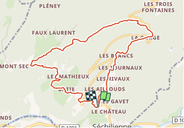
Trail Walking of 11.3 km to be discovered at Auvergne-Rhône-Alpes, Isère, Séchilienne. This trail is proposed by Emelle.
Description
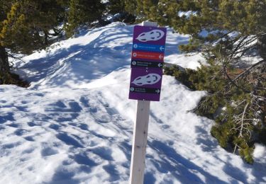
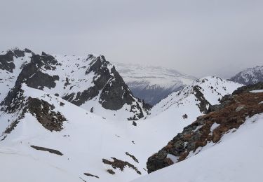
Petits ruisseaux sur la partie basse des Pavies de Séchilienne du fait des fortes pluies les jours précédents et la fonte des neiges, rendant la montée glissante. Pavies qu'il vaut mieux monter que descendre de fait.
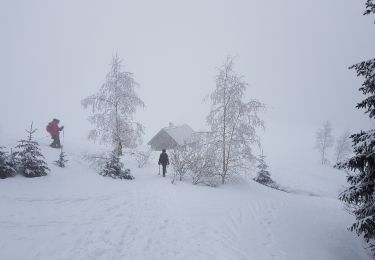
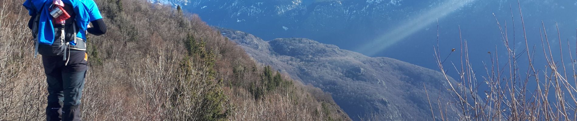
Positioning
Country:
France
Region :
Auvergne-Rhône-Alpes
Department/Province :
Isère
Municipality :
Séchilienne
Location:
Unknown
Start:(Dec)
Start:(UTM)
722847 ; 4993346 (31T) N.
Comments
Trails nearby
![Trail Snowshoes La Morte - Belvedere et Balcon de La Romanche - Photo](https://media.geolcdn.com/t/375/260/ext.jpg?maxdim=2&url=https%3A%2F%2Fservices.sitytrail.com%2FGeolivesWS%2FDownloadMedia.ashx%3FTrailID%3D911113%26Media%3Dfix__20180222125140.jpg)
![Snowshoes Snowshoes](https://static1.geolcdn.com/sitytour/trail-icons/504.png)
Belvedere et Balcon de La Romanche
Snowshoes
Medium
(1)
La Morte,
Auvergne-Rhône-Alpes,
Isère,
France
![](/images/other/stat-length.png)
10.3 km | 16.8 km-effort
4h 18min
![](https://static1.geolcdn.com/siteimages/upload/files/16400158638029165_repeat_loop_refresh_sync_direction_icon.png)
Yes
![Trail Running Vizille - Echappée Belle 2013 - Photo](https://media.geolcdn.com/t/375/260/ext.jpg?maxdim=2&url=https%3A%2F%2Fstatic1.geolcdn.com%2Fsiteimages%2Fupload%2Ffiles%2F1524743154running.jpg)
![Running Running](https://static1.geolcdn.com/sitytour/trail-icons/103.png)
Echappée Belle 2013
Running
Very difficult
(1)
Vizille,
Auvergne-Rhône-Alpes,
Isère,
France
![](/images/other/stat-length.png)
136 km | 279 km-effort
60h 0min
![](https://static1.geolcdn.com/siteimages/upload/files/16400158638029165_repeat_loop_refresh_sync_direction_icon.png)
No
![Trail Walking Séchilienne - Lac de Luitel - Pic de l'oeilly - Photo](https://media.geolcdn.com/t/375/260/392243d2-0bef-4c0e-a978-68f4c5437966.jpg&format=jpg&maxdim=2)
![Walking Walking](https://static1.geolcdn.com/sitytour/trail-icons/101.png)
Lac de Luitel - Pic de l'oeilly
Walking
Easy
Séchilienne,
Auvergne-Rhône-Alpes,
Isère,
France
![](/images/other/stat-length.png)
7.3 km | 11.1 km-effort
2h 26min
![](https://static1.geolcdn.com/siteimages/upload/files/16400158638029165_repeat_loop_refresh_sync_direction_icon.png)
Yes
![Trail Walking Vaulnaveys-le-Haut - Le Lac Achard - Le Col de L'Infernet - Photo](https://media.geolcdn.com/t/375/260/2b2ec1fe-50ad-47bf-b539-f816d718554b.jpg&format=jpg&maxdim=2)
![Walking Walking](https://static1.geolcdn.com/sitytour/trail-icons/101.png)
Le Lac Achard - Le Col de L'Infernet
Walking
Medium
Vaulnaveys-le-Haut,
Auvergne-Rhône-Alpes,
Isère,
France
![](/images/other/stat-length.png)
10.8 km | 16.6 km-effort
3h 47min
![](https://static1.geolcdn.com/siteimages/upload/files/16400158638029165_repeat_loop_refresh_sync_direction_icon.png)
Yes
![Trail Walking Vaulnaveys-le-Haut - col de la botte - Photo](https://media.geolcdn.com/t/375/260/6bdeb5ce-b8bb-4cb6-9f16-db19b5cd3724.jpg&format=jpg&maxdim=2)
![Walking Walking](https://static1.geolcdn.com/sitytour/trail-icons/101.png)
col de la botte
Walking
Very difficult
Vaulnaveys-le-Haut,
Auvergne-Rhône-Alpes,
Isère,
France
![](/images/other/stat-length.png)
11 km | 19.4 km-effort
3h 3min
![](https://static1.geolcdn.com/siteimages/upload/files/16400158638029165_repeat_loop_refresh_sync_direction_icon.png)
No
![Trail Walking Laffrey - tour du lac de la laffrey - Photo](https://media.geolcdn.com/t/375/260/912e7b86-88b6-42fd-9652-ced4f1ef2e80.jpg&format=jpg&maxdim=2)
![Walking Walking](https://static1.geolcdn.com/sitytour/trail-icons/101.png)
tour du lac de la laffrey
Walking
Difficult
Laffrey,
Auvergne-Rhône-Alpes,
Isère,
France
![](/images/other/stat-length.png)
11.3 km | 15.6 km-effort
2h 59min
![](https://static1.geolcdn.com/siteimages/upload/files/16400158638029165_repeat_loop_refresh_sync_direction_icon.png)
Yes
![Trail Walking Vaulnaveys-le-Bas - Montchaffrey/chartreuse de premol - Photo](https://media.geolcdn.com/t/375/260/bb0c8a32-d481-4cd5-bf35-438acdb94f2e.jpg&format=jpg&maxdim=2)
![Walking Walking](https://static1.geolcdn.com/sitytour/trail-icons/101.png)
Montchaffrey/chartreuse de premol
Walking
Very difficult
Vaulnaveys-le-Bas,
Auvergne-Rhône-Alpes,
Isère,
France
![](/images/other/stat-length.png)
15 km | 23 km-effort
3h 54min
![](https://static1.geolcdn.com/siteimages/upload/files/16400158638029165_repeat_loop_refresh_sync_direction_icon.png)
Yes
![Trail Walking Laffrey - Tour du Grand Lac de Laffrey en circuit - Photo](https://media.geolcdn.com/t/375/260/65f962d6-a7cb-4b2b-b08e-faf212febe11.jpg&format=jpg&maxdim=2)
![Walking Walking](https://static1.geolcdn.com/sitytour/trail-icons/101.png)
Tour du Grand Lac de Laffrey en circuit
Walking
Medium
Laffrey,
Auvergne-Rhône-Alpes,
Isère,
France
![](/images/other/stat-length.png)
17.5 km | 25 km-effort
6h 33min
![](https://static1.geolcdn.com/siteimages/upload/files/16400158638029165_repeat_loop_refresh_sync_direction_icon.png)
No
![Trail Walking Chamrousse - Croix de Chamrousse depuis l'Arselle - Photo](https://media.geolcdn.com/t/375/260/a0ae59da-2d76-4e1e-9b44-9b7b3ab34796.jpg&format=jpg&maxdim=2)
![Walking Walking](https://static1.geolcdn.com/sitytour/trail-icons/101.png)
Croix de Chamrousse depuis l'Arselle
Walking
Difficult
Chamrousse,
Auvergne-Rhône-Alpes,
Isère,
France
![](/images/other/stat-length.png)
11 km | 19.5 km-effort
5h 44min
![](https://static1.geolcdn.com/siteimages/upload/files/16400158638029165_repeat_loop_refresh_sync_direction_icon.png)
Yes