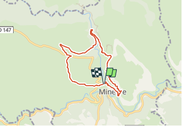
![](/images/other/stat-length.png)
![Trail Walking Minerve - Boucle MINERVE Gorge brian - Photo](https://media.geolcdn.com/t/1900/400/ext.pjpeg?maxdim=2&url=https%3A%2F%2Fstatic1.geolcdn.com%2Fsiteimages%2Fupload%2Ffiles%2F1553511878bg_sport_marche.png)
Boucle MINERVE Gorge brian
611686735
User
![Length](/images/other/stat-length.png)
![Max alt](https://static1.geolcdn.com/siteimages/upload/files/1508320355ic_sort_altitude_max_24dp.png)
![Uphill gradient](https://static1.geolcdn.com/siteimages/upload/files/1508320355ic_sort_den_pos_24dp.png)
![Km-Effort](/images/other/stat-length.png)
![Min alt](https://static1.geolcdn.com/siteimages/upload/files/1508320355ic_sort_altitude_min_24dp.png)
![Downhill gradient](https://static1.geolcdn.com/siteimages/upload/files/1508320355ic_sort_den_neg_24dp.png)
![Boucle](https://static1.geolcdn.com/siteimages/upload/files/16400158638029165_repeat_loop_refresh_sync_direction_icon.png)
![Walking](https://static1.geolcdn.com/sitytour/trail-icons/101.png)
2h31
Difficulty : Medium
![Scan this QR Code to open this trail in the SityTrail application](https://capi.geolives.com/qq0zvz2zws4bq2lad0pu/sitytour/trails/3889147/qr.png?size=200)
FREE GPS app for hiking
About
Trail Walking of 7.2 km to be discovered at Occitania, Hérault, Minerve. This trail is proposed by 611686735.
Description
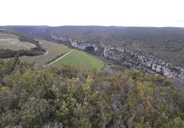
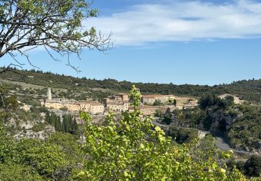
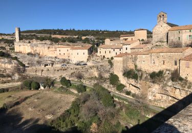
Dans ce circuit autour de Minerve, tout y est ! Les ponts naturels de la Cesse, la garrigue, les passages aériens des gorges du Brian et, bien sûr, les rues pavées de la cité.
Attention : après un épisode pluvieux, nous vous conseillons de vous renseigner sur les conditions de franchissement de la rivière du Brian : le passage à gué entre la cité et la catapulte peut parfois être recouvert d'eau ou devenir glissant.
De Etape 1 à Etape 2
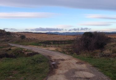
Longer la route d’accès au parking puis la D 147E à gauche sur400 m (vue sur les ponts naturels des gorges de la Cesse).
De Etape 2 à Etape 3
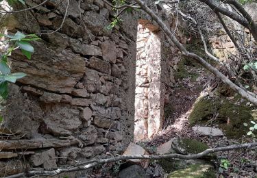
Emprunter le chemin à droite sur 350 m, puis descendre à gauchedans le maquis. Franchir le petit gué (souvent à sec) et monter en direction des pins. Après le mazet, tourner à droite le long de la vigne, puis suivre la piste à droite et continuer tout droit par la grande piste. Elle traverse le ravin de la Loubatière (abris troglodytes) et mène à un croisement.
De Etape 3 à Etape 4
Monter par la piste à gauche sur 800 m. Traverser la D 147 et continuer par la piste qui s’élève à gauche. Ignorer la piste à gauche et poursuivre tout droit sur la piste cimentée qui descend vers les gorges du Brian.
De Etape 4 à Etape 5
Dans le virage en épingle, quitter la piste pour le petit chemin à droite. Après le réservoir, continuer à flnc sur 450 m, puis dévaler le sentier à gauche. Passer le petit gué, puis descendre par la piste vers la station de pompage et poursuivre par le chemin le long du Brian (dalles glissantes). Traverser le pont de Daniel (prudence, parapet bas !) et, sur la rive gauche, grimper par le sentier à flnc jusqu’au carrefour.
De Etape 5 à Etape 6
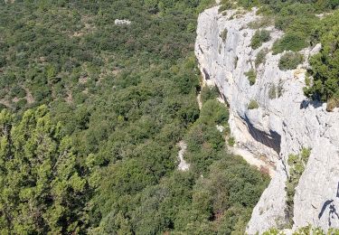
Continuer à droite par le sentier abrupt (prudence à l’abord des falaises) et arriver sur un replat. Le sentier tourne à gauche, remonte la combe à gauche et parvient sur le plateau. Avancer dans la garrigue sur 200 m.
Etape 6
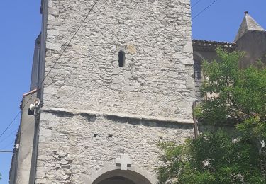
Prendre la large piste à droite sur 1,5 km. Elle domine les gorges du Brian et la cité de Minerve. Après la catapulte, descendre par le sentier à droite, traverser la passerelle et monter dans la cité par les escaliers. Emprunter la Grand-Rue à droite puis la rue des remparts. À la sortie du village, après la tour (Candéla), gravir la ruelle afin de rejoindre le parking.
Positioning
Comments
Trails nearby
![Trail Walking Cesseras - Grotte Aldène Cesseras - Photo](https://media.geolcdn.com/t/375/260/ext.jpg?maxdim=2&url=https%3A%2F%2Fmedia.geolcdn.com%2Ff%2Ffbc77cc8-93f1-4b6b-b038-073024d6a586.jpg)
![Walking Walking](https://static1.geolcdn.com/sitytour/trail-icons/101.png)
Walking
![](/images/other/stat-length.png)
![](https://static1.geolcdn.com/siteimages/upload/files/16400158638029165_repeat_loop_refresh_sync_direction_icon.png)
![Trail Walking Cesseras - 2023-04-08_21h30m21_Cesseras 10kms - Photo](https://media.geolcdn.com/t/375/260/ext.jpg?maxdim=2&url=https%3A%2F%2Fmedia.geolcdn.com%2Ff%2F63ef11e1-9828-4e19-8811-ad8eeda1adef.jpg)
![Walking Walking](https://static1.geolcdn.com/sitytour/trail-icons/101.png)
Walking
![](/images/other/stat-length.png)
![](https://static1.geolcdn.com/siteimages/upload/files/16400158638029165_repeat_loop_refresh_sync_direction_icon.png)
![Trail Walking Aigne - Aigne - Saume Longue - Photo](https://media.geolcdn.com/t/375/260/ext.jpg?maxdim=2&url=https%3A%2F%2Fservices.sitytrail.com%2FGeolivesWS%2FDownloadMedia.ashx%3FTrailID%3D373254%26Media%3D20141229163850.jpg)
![Walking Walking](https://static1.geolcdn.com/sitytour/trail-icons/101.png)
Walking
![](/images/other/stat-length.png)
![](https://static1.geolcdn.com/siteimages/upload/files/16400158638029165_repeat_loop_refresh_sync_direction_icon.png)
![Trail sport Minerve - Minerve bouclé Hérault - Photo](https://media.geolcdn.com/t/375/260/ext.jpg?maxdim=2&url=https%3A%2F%2Fmedia.geolcdn.com%2Ff%2Fd578c921-3c99-4e11-b589-7310c0cb7ada.jpg)
sport
![](/images/other/stat-length.png)
![](https://static1.geolcdn.com/siteimages/upload/files/16400158638029165_repeat_loop_refresh_sync_direction_icon.png)
![Trail Walking Minerve - Les dolmens de Vieulac - Photo](https://media.geolcdn.com/t/375/260/ext.jpg?maxdim=2&url=https%3A%2F%2Fmedia.geolcdn.com%2Ff%2F196751be-1369-4baa-8673-7b511991989e.jpg)
![Walking Walking](https://static1.geolcdn.com/sitytour/trail-icons/101.png)
Walking
![](/images/other/stat-length.png)
![](https://static1.geolcdn.com/siteimages/upload/files/16400158638029165_repeat_loop_refresh_sync_direction_icon.png)
![Trail Walking Azillanet - Azillanet Minerve - Photo](https://media.geolcdn.com/t/375/260/ext.jpg?maxdim=2&url=https%3A%2F%2Fmedia.geolcdn.com%2Ff%2F17a8c3f2-392a-4950-a09a-5c0f5e3f5c78.jpg)
![Walking Walking](https://static1.geolcdn.com/sitytour/trail-icons/101.png)
Walking
![](/images/other/stat-length.png)
![](https://static1.geolcdn.com/siteimages/upload/files/16400158638029165_repeat_loop_refresh_sync_direction_icon.png)
![Trail Walking La Caunette - La Caunette - Photo](https://media.geolcdn.com/t/375/260/ext.jpg?maxdim=2&url=https%3A%2F%2Fmedia.geolcdn.com%2Ff%2F023ef97f-7396-4efd-82f5-9f38cf32c62c.jpg)
![Walking Walking](https://static1.geolcdn.com/sitytour/trail-icons/101.png)
Walking
![](/images/other/stat-length.png)
![](https://static1.geolcdn.com/siteimages/upload/files/16400158638029165_repeat_loop_refresh_sync_direction_icon.png)
![Trail Mountain bike Minerve - minerve - Photo](https://media.geolcdn.com/t/375/260/ext.jpg?maxdim=2&url=https%3A%2F%2Fmedia.geolcdn.com%2Ff%2F99c6c1a4-f768-4c35-9e57-edeb97d705f4.jpg)
![Mountain bike Mountain bike](https://static1.geolcdn.com/sitytour/trail-icons/202.png)
![Trail On foot Minerve - Les Mégalithes de Minerve - Photo](https://media.geolcdn.com/t/375/260/ext.jpg?maxdim=2&url=https%3A%2F%2Fmedia.geolcdn.com%2Ff%2F09b6594c-9884-4989-80d8-c89c14cd8660.jpeg)
![On foot On foot](https://static1.geolcdn.com/sitytour/trail-icons/100.png)
On foot
![](/images/other/stat-length.png)
![](https://static1.geolcdn.com/siteimages/upload/files/16400158638029165_repeat_loop_refresh_sync_direction_icon.png)