![](/images/other/stat-length.png)
![Trail Walking Meudon - Jardins et Réseau H. - Photo](https://media.geolcdn.com/t/1900/400/ext.pjpeg?maxdim=2&url=https%3A%2F%2Fstatic1.geolcdn.com%2Fsiteimages%2Fupload%2Ffiles%2F1553511878bg_sport_marche.png)
Jardins et Réseau H.
DURANDPGL
User
![Length](/images/other/stat-length.png)
Length
11.1 km
![Max alt](https://static1.geolcdn.com/siteimages/upload/files/1508320355ic_sort_altitude_max_24dp.png)
Max alt
188 m
![Uphill gradient](https://static1.geolcdn.com/siteimages/upload/files/1508320355ic_sort_den_pos_24dp.png)
Uphill gradient
210 m
![Km-Effort](/images/other/stat-length.png)
Km-Effort
13.9 km
![Min alt](https://static1.geolcdn.com/siteimages/upload/files/1508320355ic_sort_altitude_min_24dp.png)
Min alt
77 m
![Downhill gradient](https://static1.geolcdn.com/siteimages/upload/files/1508320355ic_sort_den_neg_24dp.png)
Downhill gradient
207 m
![Boucle](https://static1.geolcdn.com/siteimages/upload/files/16400158638029165_repeat_loop_refresh_sync_direction_icon.png)
Boucle
Yes
Creation date :
2015-02-22 00:00:00.0
Updated on :
2015-02-22 00:00:00.0
![Walking](https://static1.geolcdn.com/sitytour/trail-icons/101.png)
2h59
Difficulty : Medium
![Scan this QR Code to open this trail in the SityTrail application](https://capi.geolives.com/qq0zvz2zws4bq2lad0pu/sitytour/trails/388768/qr.png?size=200)
FREE GPS app for hiking
About
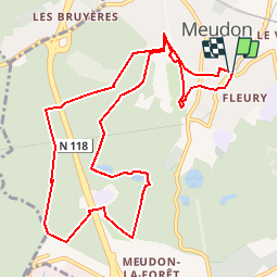
Trail Walking of 11.1 km to be discovered at Ile-de-France, Hauts-de-Seine, Meudon. This trail is proposed by DURANDPGL.
Description
depuis la gare de Meudon Val Fleury, visite de l'orangerie et de la Terrasse de l'Observatoire puis des principaux vestiges du Réseau Hydraulique dans la forêt de Meudon
Positioning
Country:
France
Region :
Ile-de-France
Department/Province :
Hauts-de-Seine
Municipality :
Meudon
Location:
Unknown
Start:(Dec)
Start:(UTM)
444271 ; 5406401 (31U) N.
Comments
Trails nearby
![Trail Walking Chaville - Le Sentier des 7 étangs - Photo](https://media.geolcdn.com/t/375/260/ext.jpg?maxdim=2&url=https%3A%2F%2Fservices.sitytrail.com%2FGeolivesWS%2FDownloadMedia.ashx%3FTrailID%3D110203%26Media%3D5435_1.jpg)
![Walking Walking](https://static1.geolcdn.com/sitytour/trail-icons/101.png)
Le Sentier des 7 étangs
Walking
Difficult
(5)
Chaville,
Ile-de-France,
Hauts-de-Seine,
France
![](/images/other/stat-length.png)
23 km | 31 km-effort
5h 0min
![](https://static1.geolcdn.com/siteimages/upload/files/16400158638029165_repeat_loop_refresh_sync_direction_icon.png)
Yes
![Trail Walking Chaville - GRP CV-IDF 20R Chaville à Vaucresson - Photo](https://media.geolcdn.com/t/375/260/ee9d0d3a-696b-449f-af8b-f1928f5c8b40.jpg&format=jpg&maxdim=2)
![Walking Walking](https://static1.geolcdn.com/sitytour/trail-icons/101.png)
GRP CV-IDF 20R Chaville à Vaucresson
Walking
Medium
(1)
Chaville,
Ile-de-France,
Hauts-de-Seine,
France
![](/images/other/stat-length.png)
8.2 km | 11.1 km-effort
2h 30min
![](https://static1.geolcdn.com/siteimages/upload/files/16400158638029165_repeat_loop_refresh_sync_direction_icon.png)
No
![Trail Walking Paris - DP75-13 De Vaugirard à Sèvres-Babylone - Photo](https://media.geolcdn.com/t/375/260/ef3b90ff-736f-49ef-8953-54f5a63f322a.jpg&format=jpg&maxdim=2)
![Walking Walking](https://static1.geolcdn.com/sitytour/trail-icons/101.png)
DP75-13 De Vaugirard à Sèvres-Babylone
Walking
Easy
(1)
Paris,
Ile-de-France,
Paris,
France
![](/images/other/stat-length.png)
4.4 km | 5 km-effort
1h 8min
![](https://static1.geolcdn.com/siteimages/upload/files/16400158638029165_repeat_loop_refresh_sync_direction_icon.png)
No
![Trail Walking Paris - DP75-32 De Charles-Michel à Plaisance - Photo](https://media.geolcdn.com/t/375/260/392c6463-e03b-44f3-85b1-02c32ee10469.jpg&format=jpg&maxdim=2)
![Walking Walking](https://static1.geolcdn.com/sitytour/trail-icons/101.png)
DP75-32 De Charles-Michel à Plaisance
Walking
Easy
(1)
Paris,
Ile-de-France,
Paris,
France
![](/images/other/stat-length.png)
4.3 km | 5.1 km-effort
1h 10min
![](https://static1.geolcdn.com/siteimages/upload/files/16400158638029165_repeat_loop_refresh_sync_direction_icon.png)
No
![Trail Cycle Paris - Paris au bord de Seine - Photo](https://media.geolcdn.com/t/375/260/ext.jpg?maxdim=2&url=https%3A%2F%2Fservices.sitytrail.com%2FGeolivesWS%2FDownloadMedia.ashx%3FTrailID%3D137119%26Media%3D20120703185331.jpg)
![Cycle Cycle](https://static1.geolcdn.com/sitytour/trail-icons/200.png)
Paris au bord de Seine
Cycle
Very easy
(1)
Paris,
Ile-de-France,
Paris,
France
![](/images/other/stat-length.png)
11.4 km | 14.2 km-effort
46min
![](https://static1.geolcdn.com/siteimages/upload/files/16400158638029165_repeat_loop_refresh_sync_direction_icon.png)
No
![Trail Walking Paris - 75-04-Paris les Ponts 13km-493-55- - Photo](https://media.geolcdn.com/t/375/260/ffa79fa9-c1ae-4345-951e-9e30af6e17a7.jpg&format=jpg&maxdim=2)
![Walking Walking](https://static1.geolcdn.com/sitytour/trail-icons/101.png)
75-04-Paris les Ponts 13km-493-55-
Walking
Easy
(1)
Paris,
Ile-de-France,
Paris,
France
![](/images/other/stat-length.png)
13.1 km | 16.3 km-effort
3h 22min
![](https://static1.geolcdn.com/siteimages/upload/files/16400158638029165_repeat_loop_refresh_sync_direction_icon.png)
No
![Trail Walking Chaville - Sentier des deux Forêts - Meudon et Verrières - Photo](https://media.geolcdn.com/t/375/260/ext.jpg?maxdim=2&url=https%3A%2F%2Fservices.sitytrail.com%2FGeolivesWS%2FDownloadMedia.ashx%3FTrailID%3D110156%26Media%3D5356_1.jpg)
![Walking Walking](https://static1.geolcdn.com/sitytour/trail-icons/101.png)
Sentier des deux Forêts - Meudon et Verrières
Walking
Difficult
(2)
Chaville,
Ile-de-France,
Hauts-de-Seine,
France
![](/images/other/stat-length.png)
23 km | 29 km-effort
5h 0min
![](https://static1.geolcdn.com/siteimages/upload/files/16400158638029165_repeat_loop_refresh_sync_direction_icon.png)
Yes
![Trail Walking Sceaux - Les Hauts de Bièvre - Photo](https://media.geolcdn.com/t/375/260/ext.jpg?maxdim=2&url=https%3A%2F%2Fservices.sitytrail.com%2FGeolivesWS%2FDownloadMedia.ashx%3FTrailID%3D110019%26Media%3D5127_1.jpg)
![Walking Walking](https://static1.geolcdn.com/sitytour/trail-icons/101.png)
Les Hauts de Bièvre
Walking
Difficult
(2)
Sceaux,
Ile-de-France,
Hauts-de-Seine,
France
![](/images/other/stat-length.png)
25 km | 30 km-effort
6h 0min
![](https://static1.geolcdn.com/siteimages/upload/files/16400158638029165_repeat_loop_refresh_sync_direction_icon.png)
Yes
![Trail Walking Boulogne-Billancourt - Parc de St Cloud et forêt de Fausses Reposes - Photo](https://media.geolcdn.com/t/375/260/ext.jpg?maxdim=2&url=https%3A%2F%2Fservices.sitytrail.com%2FGeolivesWS%2FDownloadMedia.ashx%3FTrailID%3D106613%26Media%3D11213_2.jpg)
![Walking Walking](https://static1.geolcdn.com/sitytour/trail-icons/101.png)
Parc de St Cloud et forêt de Fausses Reposes
Walking
Medium
(1)
Boulogne-Billancourt,
Ile-de-France,
Hauts-de-Seine,
France
![](/images/other/stat-length.png)
18.2 km | 23 km-effort
4h 30min
![](https://static1.geolcdn.com/siteimages/upload/files/16400158638029165_repeat_loop_refresh_sync_direction_icon.png)
No