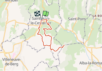
![](/images/other/stat-length.png)
![Trail Walking Saint-Jean-le-Centenier - 07 Saint-Jean-le-Centenier Croix de Juliau - Photo](https://media.geolcdn.com/t/1900/400/ext.pjpeg?maxdim=2&url=https%3A%2F%2Fstatic1.geolcdn.com%2Fsiteimages%2Fupload%2Ffiles%2F1553511878bg_sport_marche.png)
07 Saint-Jean-le-Centenier Croix de Juliau
Maryma
User
![Length](/images/other/stat-length.png)
![Max alt](https://static1.geolcdn.com/siteimages/upload/files/1508320355ic_sort_altitude_max_24dp.png)
![Uphill gradient](https://static1.geolcdn.com/siteimages/upload/files/1508320355ic_sort_den_pos_24dp.png)
![Km-Effort](/images/other/stat-length.png)
![Min alt](https://static1.geolcdn.com/siteimages/upload/files/1508320355ic_sort_altitude_min_24dp.png)
![Downhill gradient](https://static1.geolcdn.com/siteimages/upload/files/1508320355ic_sort_den_neg_24dp.png)
![Boucle](https://static1.geolcdn.com/siteimages/upload/files/16400158638029165_repeat_loop_refresh_sync_direction_icon.png)
![Walking](https://static1.geolcdn.com/sitytour/trail-icons/101.png)
4h08
Difficulty : Medium
![Nordic walking](https://static1.geolcdn.com/sitytour/trail-icons/102.png)
3h00
Difficulty : Very easy
![Scan this QR Code to open this trail in the SityTrail application](https://capi.geolives.com/qq0zvz2zws4bq2lad0pu/sitytour/trails/3884165/qr.png?size=200)
FREE GPS app for hiking
About
Trail Walking of 13.4 km to be discovered at Auvergne-Rhône-Alpes, Ardèche, Saint-Jean-le-Centenier. This trail is proposed by Maryma.
Description
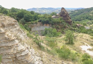
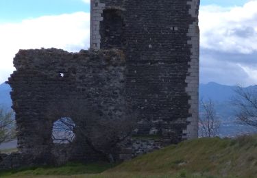
Magnifique point de vue de la Croix de Juliau (alt.553m) sur le plateau du Coiron et la plaine de Valvignère.
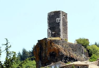
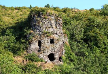
Theoule, ce terme vient de l'occitan teule et signifie : tuile, le lieu où l'on cuisait les tuiles et les poteries.
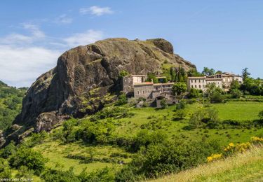
La tradition prétend que le toponyme Juliau a pour origine le passage de Jules César. L'étymologie de Juliau provient bien du nom ou du prénom de Jules, mais sans rapport avec César!
Positioning
Comments
Trails nearby
![Trail Walking Saint-Pons - St-Pons](https://media.geolcdn.com/t/375/260/49091a69-1e24-42da-a42c-558f715b7cf2.jpg&format=jpg&maxdim=2)
![Walking Walking](https://static1.geolcdn.com/sitytour/trail-icons/101.png)
Walking
![](/images/other/stat-length.png)
![](https://static1.geolcdn.com/siteimages/upload/files/16400158638029165_repeat_loop_refresh_sync_direction_icon.png)
![Trail Walking Alba-la-Romaine - Alba côté Coiron 7km - Photo](https://media.geolcdn.com/t/375/260/a3628db1-82f7-410a-bbb5-05b986f870eb.jpg&format=jpg&maxdim=2)
![Walking Walking](https://static1.geolcdn.com/sitytour/trail-icons/101.png)
Walking
![](/images/other/stat-length.png)
![](https://static1.geolcdn.com/siteimages/upload/files/16400158638029165_repeat_loop_refresh_sync_direction_icon.png)
![Trail Walking Alba-la-Romaine - 2022-03-12_17h47m49_Sceautres-La carrière 15km.gpx.xml - Photo](https://media.geolcdn.com/t/375/260/bc490022-33bf-4369-aab3-d65614438b0b.jpg&format=jpg&maxdim=2)
![Walking Walking](https://static1.geolcdn.com/sitytour/trail-icons/101.png)
Walking
![](/images/other/stat-length.png)
![](https://static1.geolcdn.com/siteimages/upload/files/16400158638029165_repeat_loop_refresh_sync_direction_icon.png)
![Trail Walking Mirabel - 2025-01-25_15h34m21_SityTrail - 3633141 - mirabel-11km-den367m- - Photo](https://media.geolcdn.com/t/375/260/e7aad9c3-6c53-4829-ad7f-8298786bbba5.jpg&format=jpg&maxdim=2)
![Walking Walking](https://static1.geolcdn.com/sitytour/trail-icons/101.png)
Walking
![](/images/other/stat-length.png)
![](https://static1.geolcdn.com/siteimages/upload/files/16400158638029165_repeat_loop_refresh_sync_direction_icon.png)
![Trail Walking Saint-Gineys-en-Coiron - 07 claduergue 09.10.2022 reco - Photo](https://media.geolcdn.com/t/375/260/0db5ceb1-c859-4947-98bb-8940f8fd6419.jpg&format=jpg&maxdim=2)
![Walking Walking](https://static1.geolcdn.com/sitytour/trail-icons/101.png)
Walking
![](/images/other/stat-length.png)
![](https://static1.geolcdn.com/siteimages/upload/files/16400158638029165_repeat_loop_refresh_sync_direction_icon.png)
![Trail Walking Mirabel - 07 mirabel - Photo](https://media.geolcdn.com/t/375/260/915b720a-5cae-485d-9914-36e4a159eaad.jpg&format=jpg&maxdim=2)
![Walking Walking](https://static1.geolcdn.com/sitytour/trail-icons/101.png)
Walking
![](/images/other/stat-length.png)
![](https://static1.geolcdn.com/siteimages/upload/files/16400158638029165_repeat_loop_refresh_sync_direction_icon.png)
![Trail Walking Saint-Gineys-en-Coiron - 07 cascade claduegne - Photo](https://media.geolcdn.com/t/375/260/96b7464a-365b-4e1a-bf3d-e9681d8c98e5.jpg&format=jpg&maxdim=2)
![Walking Walking](https://static1.geolcdn.com/sitytour/trail-icons/101.png)
Walking
![](/images/other/stat-length.png)
![](https://static1.geolcdn.com/siteimages/upload/files/16400158638029165_repeat_loop_refresh_sync_direction_icon.png)
![Trail Walking Saint-Jean-le-Centenier - 2024-10-24_16h13m18_Les_Balmes_de_Montbrun___Mirabel - Photo](https://media.geolcdn.com/t/375/260/dbc645ad-56e8-488c-ac1e-c71e50cea5de.jpg&format=jpg&maxdim=2)
![Walking Walking](https://static1.geolcdn.com/sitytour/trail-icons/101.png)
Walking
![](/images/other/stat-length.png)
![](https://static1.geolcdn.com/siteimages/upload/files/16400158638029165_repeat_loop_refresh_sync_direction_icon.png)
![Trail Walking Villeneuve-de-Berg - Les Crêtes de Villeneuve-de -Berg 13km. - Photo](https://media.geolcdn.com/t/375/260/77790bd6-03c9-446a-92b5-96886f6a37ec.jpg&format=jpg&maxdim=2)
![Walking Walking](https://static1.geolcdn.com/sitytour/trail-icons/101.png)
Walking
![](/images/other/stat-length.png)
![](https://static1.geolcdn.com/siteimages/upload/files/16400158638029165_repeat_loop_refresh_sync_direction_icon.png)