


parcul comana

hautln
User
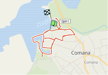

Length
6.3 km

Max alt
53 m

Uphill gradient
35 m
Km-Effort
6.8 km

Min alt
42 m

Downhill gradient
32 m
Boucle
No
Creation date :
2023-12-02 11:57:23.216
Updated on :
2023-12-02 14:14:25.338
2h16
Difficulty : Medium

FREE GPS app for hiking
 SityTrail
IGN / Geographical institutes
SityTrail World
The world is yours!
About
Trail Walking of 6.3 km to be discovered at Giurgiu. This trail is proposed by hautln.
Positioning
Country:
Romania
Region :
Giurgiu
Department/Province :
Unknown
Municipality :
Unknown
Location:
Unknown
Start:(Dec)
Start:(UTM)
430864 ; 4891962 (35T) N.
Comments
Trails nearby