![](/images/other/stat-length.png)
![Trail Walking Montaut - Circuit des 5 clochers - Photo](https://media.geolcdn.com/t/1900/400/ext.pjpeg?maxdim=2&url=https%3A%2F%2Fstatic1.geolcdn.com%2Fsiteimages%2Fupload%2Ffiles%2F1553511878bg_sport_marche.png)
Circuit des 5 clochers
DuMarsan
User
![Length](/images/other/stat-length.png)
Length
17.2 km
![Max alt](https://static1.geolcdn.com/siteimages/upload/files/1508320355ic_sort_altitude_max_24dp.png)
Max alt
124 m
![Uphill gradient](https://static1.geolcdn.com/siteimages/upload/files/1508320355ic_sort_den_pos_24dp.png)
Uphill gradient
281 m
![Km-Effort](/images/other/stat-length.png)
Km-Effort
21 km
![Min alt](https://static1.geolcdn.com/siteimages/upload/files/1508320355ic_sort_altitude_min_24dp.png)
Min alt
55 m
![Downhill gradient](https://static1.geolcdn.com/siteimages/upload/files/1508320355ic_sort_den_neg_24dp.png)
Downhill gradient
279 m
![Boucle](https://static1.geolcdn.com/siteimages/upload/files/16400158638029165_repeat_loop_refresh_sync_direction_icon.png)
Boucle
Yes
Creation date :
2015-02-20 00:00:00.0
Updated on :
2015-02-20 00:00:00.0
![Walking](https://static1.geolcdn.com/sitytour/trail-icons/101.png)
3h08
Difficulty : Easy
![Scan this QR Code to open this trail in the SityTrail application](https://capi.geolives.com/qq0zvz2zws4bq2lad0pu/sitytour/trails/388202/qr.png?size=200)
FREE GPS app for hiking
About
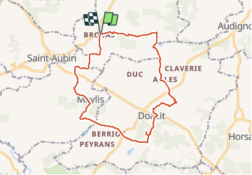
Trail Walking of 17.2 km to be discovered at New Aquitaine, Landes, Montaut. This trail is proposed by DuMarsan.
Description
Rando issue du Randoguide de Haute-Chalosse 4.10 du conseil général des Landes.
Joli parcours vallonné dans les paysages de Chalosse avec découverte de 5 clochers ( Brocas , Aules, Doazit, du Mus et Maylis ).
3 départs possible ( Brocas , Doazit ou Maylis )
Positioning
Country:
France
Region :
New Aquitaine
Department/Province :
Landes
Municipality :
Montaut
Location:
Unknown
Start:(Dec)
Start:(UTM)
687539 ; 4843286 (30T) N.
Comments
Trails nearby
![Trail Walking Banos - Banos-Montaut - Photo](https://media.geolcdn.com/t/375/260/ext.jpg?maxdim=2&url=https%3A%2F%2Fservices.sitytrail.com%2FGeolivesWS%2FDownloadMedia.ashx%3FTrailID%3D1014826%26Media%3Dfix__20180802142730.jpg)
![Walking Walking](https://static1.geolcdn.com/sitytour/trail-icons/101.png)
Banos-Montaut
Walking
Medium
Banos,
New Aquitaine,
Landes,
France
![](/images/other/stat-length.png)
10.8 km | 13.6 km-effort
2h 59min
![](https://static1.geolcdn.com/siteimages/upload/files/16400158638029165_repeat_loop_refresh_sync_direction_icon.png)
Yes
![Trail Walking Mugron - Mugron, Toulouzette ferme Tournier - Photo](https://media.geolcdn.com/t/375/260/ext.jpg?maxdim=2&url=https%3A%2F%2Fstatic1.geolcdn.com%2Fsiteimages%2Fupload%2Ffiles%2F1553511878bg_sport_marche.png)
![Walking Walking](https://static1.geolcdn.com/sitytour/trail-icons/101.png)
Mugron, Toulouzette ferme Tournier
Walking
Easy
Mugron,
New Aquitaine,
Landes,
France
![](/images/other/stat-length.png)
9 km | 10 km-effort
2h 0min
![](https://static1.geolcdn.com/siteimages/upload/files/16400158638029165_repeat_loop_refresh_sync_direction_icon.png)
No
![Trail Walking Toulouzette - toulouzette - Photo](https://media.geolcdn.com/t/375/260/ext.jpg?maxdim=2&url=https%3A%2F%2Fstatic1.geolcdn.com%2Fsiteimages%2Fupload%2Ffiles%2F1553511878bg_sport_marche.png)
![Walking Walking](https://static1.geolcdn.com/sitytour/trail-icons/101.png)
toulouzette
Walking
Very easy
Toulouzette,
New Aquitaine,
Landes,
France
![](/images/other/stat-length.png)
10.1 km | 11.3 km-effort
1h 46min
![](https://static1.geolcdn.com/siteimages/upload/files/16400158638029165_repeat_loop_refresh_sync_direction_icon.png)
Yes
![Trail Mountain bike Saint-Sever - Saint Sever - Hinx - 31 Km - Photo](https://media.geolcdn.com/t/375/260/ext.jpg?maxdim=2&url=https%3A%2F%2Fstatic1.geolcdn.com%2Fsiteimages%2Fupload%2Ffiles%2F1524743154velo.jpg)
![Mountain bike Mountain bike](https://static1.geolcdn.com/sitytour/trail-icons/202.png)
Saint Sever - Hinx - 31 Km
Mountain bike
Easy
Saint-Sever,
New Aquitaine,
Landes,
France
![](/images/other/stat-length.png)
31 km | 35 km-effort
1h 30min
![](https://static1.geolcdn.com/siteimages/upload/files/16400158638029165_repeat_loop_refresh_sync_direction_icon.png)
No
![Trail Walking Montaut - Montaut, St Vincent, Bâts - 7.1 - Photo](https://media.geolcdn.com/t/375/260/ext.jpg?maxdim=2&url=https%3A%2F%2Fstatic1.geolcdn.com%2Fsiteimages%2Fupload%2Ffiles%2F1553511878bg_sport_marche.png)
![Walking Walking](https://static1.geolcdn.com/sitytour/trail-icons/101.png)
Montaut, St Vincent, Bâts - 7.1
Walking
Medium
Montaut,
New Aquitaine,
Landes,
France
![](/images/other/stat-length.png)
7.1 km | 8.5 km-effort
1h 30min
![](https://static1.geolcdn.com/siteimages/upload/files/16400158638029165_repeat_loop_refresh_sync_direction_icon.png)
Yes
![Trail Walking Montaut - Montaut, banos - 10 - Photo](https://media.geolcdn.com/t/375/260/ext.jpg?maxdim=2&url=https%3A%2F%2Fstatic1.geolcdn.com%2Fsiteimages%2Fupload%2Ffiles%2F1553511878bg_sport_marche.png)
![Walking Walking](https://static1.geolcdn.com/sitytour/trail-icons/101.png)
Montaut, banos - 10
Walking
Difficult
Montaut,
New Aquitaine,
Landes,
France
![](/images/other/stat-length.png)
10.3 km | 12.9 km-effort
2h 56min
![](https://static1.geolcdn.com/siteimages/upload/files/16400158638029165_repeat_loop_refresh_sync_direction_icon.png)
Yes
![Trail Walking Banos - Banos - Photo](https://media.geolcdn.com/t/375/260/ext.jpg?maxdim=2&url=https%3A%2F%2Fstatic1.geolcdn.com%2Fsiteimages%2Fupload%2Ffiles%2F1553511878bg_sport_marche.png)
![Walking Walking](https://static1.geolcdn.com/sitytour/trail-icons/101.png)
![Trail Walking Banos - banos/ Montaut - Photo](https://media.geolcdn.com/t/375/260/ext.jpg?maxdim=2&url=https%3A%2F%2Fstatic1.geolcdn.com%2Fsiteimages%2Fupload%2Ffiles%2F1553511878bg_sport_marche.png)
![Walking Walking](https://static1.geolcdn.com/sitytour/trail-icons/101.png)
banos/ Montaut
Walking
Very easy
Banos,
New Aquitaine,
Landes,
France
![](/images/other/stat-length.png)
10.8 km | 13.6 km-effort
2h 55min
![](https://static1.geolcdn.com/siteimages/upload/files/16400158638029165_repeat_loop_refresh_sync_direction_icon.png)
Yes